(ABOVE VIDEO) Tuesday morning’s civil defense message with video courtesy Hawaii County and Ena Media Hawaii & Blue Hawaiian Helicopters
NEWS BRIEFS
- This morning’s assessment shows that the flow front remains active however has not advanced since yesterday. Activity has been limited to breakouts along the margins or sides of the flow as well as on the flow surface. The front remains approximately 480 feet from the Pahoa Village Road.
- Additional breakouts upslope of the flow front are being monitored and those breakouts currently do not present with an immediate threat to area residents.
- Yesterday, President Barack Obama declared a disaster for Hawaii due to the lava flow. The President’s action “makes federal funding available to state and eligible local governments and certain private nonprofit organizations on a cost-sharing basis for emergency protective measures taken as a result of the Pu’u ‘Ō’ō volcanic eruption and lava flow in Hawaii County,” according to FEMA. “Federal funding is also available on a cost-sharing basis for hazard mitigation measures in Hawaii County.”
PRIMARY SOURCES

This morning’s assessment shows that the flow front remains active however has not advanced since yesterday. All activity along the front has been limited to breakouts along the margins or sides of the flow as well as on the flow surface. The front remains approximately 480 feet from the Pahoa Village Road. Additional breakouts upslope of the flow front are being monitored and those breakouts currently do not present with an immediate threat to area residents. The upslope breakouts are located approximately .7 to 1.5 miles above the Apa’a Street area and along the north side of the flow and moving in a north/northeast direction.
Smoke conditions are light with light trade winds. Smoke conditions may increase in some areas and residents down wind that may be sensitive or have respiratory problems are advised to take necessary precautions and to remain indoors.
The evacuation advisory for those residents down slope of the flow will continue and residents will be kept informed of the flow status and advancement.
The Pahoa Village Road between Apa’a Street and the Post Office Road will remain closed and limited to area residents only. In addition, Civil Defense and public safety personnel will be operating in the area round the clock to maintain close observations of flow activity.
Elections are being held today and the following polling places in District 4 will be open from 7:00am to 6:00pm:
- Hawaiian Paradise Park Community center
- Keonepoko Elementary School
- Pahoa Community Center
- Pahoa High School Cafeteria
Additional updates will be broadcasted as conditions change.
We would like to thank everyone for your patience and understanding and your cooperation and assistance is greatly appreciated.Hawaii County Civil Defense on Nov. 4 at 7:30 a.m. HST

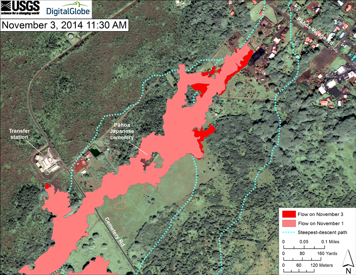
This USGS HVO map uses a satellite image acquired in March 2014 (provided by Digital Globe) as a base to show the area around the front of the June 27th lava flow. The area of the flow on November 1, 2014, at 11:00 AM is shown in pink, while widening and advancement of the flow as mapped on November 3 at 11:30 AM is shown in red. The latitude and longitude of the front of the narrow finger of lava advancing toward Pāhoa was 19.49590, -154.95256 (Decimal Degrees; WGS84). The dotted blue lines show steepest-descent paths in the area, calculated from a 1983 digital elevation model (DEM).
The flow has not advanced during the last 24 hours. At the time of mapping, the tip of the flow was stalled, but a few breakouts were active just upslope from the front.

by Big Island Video News
on at
STORY SUMMARY
The front remains approximately 480 feet from the Pahoa Village Road, all polling places open for today's elections