Map courtesy USGS
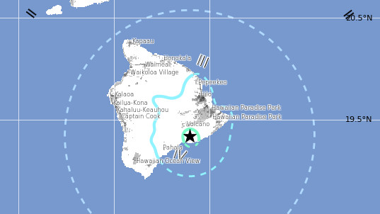
HAWAII ISLAND – The magnitude 5.0 earthquake that shook Hawaii Island on Saturday night has been upgraded to a 5.2, according to the U.S. Geological Survey. The quake was centered about 7 miles south southeast of Volcano, in the Hilina Region of Kilauea. It was first recorded at a shallow depth of 0.1 miles down, but scientists now say the quake occurred at a depth of 5.3 miles.
“Light” shaking was felt across the Big Island, from Hilo to Kona.
The USGS Hawaiian Volcano Observatory issued a news release after the quake.
The USGS “Did you feel it?” Web site received more than 740 felt reports within an hour of the earthquake. It was felt across the Island of Hawaiʻi, as well as on parts of Maui, Lāna‘i, O‘ahu. Reports indicate that residents experienced light shaking (Intensity IV) during the earthquake. At these shaking intensities, damage to buildings or structures is not expected though items not properly secured could have fallen over.
A tsunami was not generated by the earthquake, reports the Pacific Tsunami Warning Center. A Hawaii County Civil Defense message spread the word (note the message says magnitude 4.8, which was the recorded intensity when the recording was made).
The earthquake was followed by a magnitude 3.1 earthquake located about 9 miles south southeast of Volcano at a depth of 5 miles. According to HVO:
Five aftershocks were recorded within the first hour of the earthquake, including a magnitude-3.1 earthquake at 10:54 p.m. More aftershocks can be expected, including some that might be felt.
Scientists say “eight earthquakes with magnitudes of 4 or greater, including three with magnitudes of 5 or greater, have occurred in this same area, the central part of Kīlauea’s south flank, and at nearly the same depth (8–10 km or 5–6 miles), in the last 20 years. These quakes are thought to be caused by southward movement of the volcano’s south flank in response to magmatic pressure within Kilauea’s East Rift Zone.”
HVO Scientist-in-Charge Tina Neal said in the release that the earthquakes had no apparent effect on Kīlauea’s ongoing eruptions, saying “HVO monitoring networks have not detected any significant changes in activity at the summits or rift zones of Kīlauea or other Hawaiian volcanoes.”

by Big Island Video News
on at
STORY SUMMARY
HAWAII ISLAND – The magnitude 5.0 earthquake that shook Hawaii Island on Saturday night has been upgraded to a 5.2, according to the U.S. Geological Survey. The quake was centered about 7 miles south southeast of Volcano, in the Hilina Region of Kilauea. It was first recorded at a shallow depth of 0.1 miles down, […]