Image from NWS National Hurricane Center
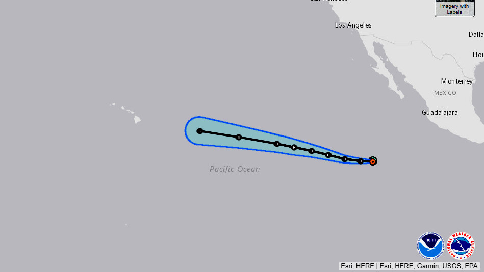
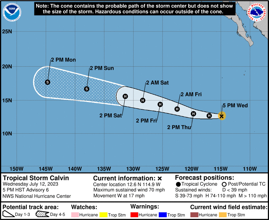
(BIVN) – As of 5 p.m. HST on Wednesday, Tropical Storm Calvin continues to intensify in the eastern Pacific. The National Hurricane Center says Calvin is forecast to become a hurricane later tonight as it moves west in the general direction of Hawaiʻi. The storm is expected to move in the central Pacific basin late Sunday.
Local forecasters say Calvin will “likely impact the state towards the middle of next week in some ways, but it is too early for any details.”
From the forecast discussion posted by the National Weather Service in Honolulu on Wednesday afternoon:
For next week, we are continuing to monitor the development of Tropical Storm Calvin in the eastern Pacific, which is expected to intensify to a Hurricane soon. It is too early to tell the details regarding Calvin impacting the Hawaiian Islands, but the latest forecast from the National Hurricane Center has Calvin moving into the Central Pacific basin late Sunday as a tropical storm. Calvin will likely impact the state in some sort of way, whether it is high surf, heavy rain, strong winds, or all of the above, it is yet to be determined. Although details are uncertain, we could begin to see impacts from Calvin as early as Tuesday, but more likely around Wednesday of next week.
As of 5 p.m. HST, Tropical Storm Calvin was located 2,705 miles east southeast of Hilo.
From the National Hurricane Center discussion at 5 p.m. HST:
Calvin continues to steadily strengthen. A couple microwave passes from within the past few hours showed that storm had a nearly closed low-level eye and a mid-level eye open to the northwest. Recent geostationary satellite imagery suggests the storm’s inner core may have experienced some dry air entrainment from that quadrant. However, deep convection with over-shooting tops is still present in the eastern portion of the circulation. Subjective satellite Dvorak estimates from SAB and TAFB were T4.0/65 kt and T3.5/55 kt, respectively. The initial intensity has been increased to 60 kt based on a blend of these estimates.
Atmospheric and oceanic conditions are conducive for additional strengthening. Calvin is forecast to be in a generally moist environment, with low vertical wind shear, and warm sea surface temperatures for the next few days. After 72 h, the SSTs beneath the storm are expected to gradually cool, while vertical wind shear increases and mid-level humidity decreases. The combination of these factors should induce a weakening trend during this portion of the forecast period. The official intensity prediction is similar to the previous advisory and is stronger than most of the guidance due to the potential for rapid intensification in the short-term forecast.
The storm is moving westward at about 15 kt. A ridge to the north is steering Calvin at a brisk pace and a west to west-northwest motion should continue through the end of the forecast period. There is still notable spread in the model guidance related to the along-track speed of the cyclone. The NHC track forecast is similar to the previous advisory and favors the faster model guidance, falling between the simple and corrected consensus aids.

by Big Island Video News
on at
STORY SUMMARY
HONOLULU, Hawaiʻi - Forecasters say Calvin "will likely impact the state towards the middle of next week in some ways, but it is too early for any details."