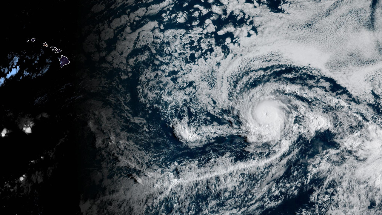
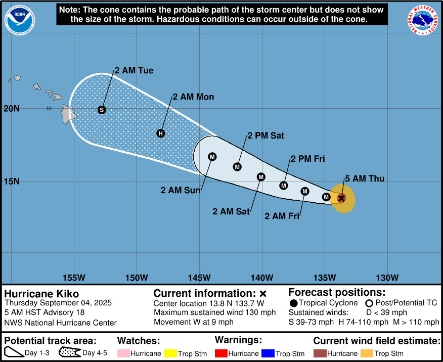
(BIVN) – Hurricane Kiko is still a major hurricane, located 1,470 miles east southeast of Hilo as of 5 a.m. HST on Thursday morning.
Kiko is a category 4 hurricane on the Saffir-Simpson Hurricane Wind Scale, moving west towards the Central Pacific at 9 mph. The storm is a little weaker, with maximum sustained winds down to 130 mph (215 km/h) with higher gusts. Fluctuations in intensity are expected in the next two to three days.
The National Weather Service in Honolulu says Kiko is forecast to move into Hawaiʻi’s eastern offshore waters, or pass 150W, late next Monday. “The track of Kiko will be determined by the drier Central Pacific environment it will be moving into the next couple of days as well as its interaction with increasing southwesterly shear brought on by (a) northwest trough,” the NWS forecasters wrote Thursday morning. “As of this time, due to the high uncertainly of Kiko’s intensity and track, the messaging for the state is focused on the potential for greater rainfall leading to a flood threat during the Monday through early Thursday time frame.”
From the National Hurricane Center discussion posted at 5 a.m. HST:
The satellite presentation of Kiko continues with a weaker depiction compared to yesterday evening, but beginning to see some stabilization in the core with a little more convective wrap within the southern flank of the eyewall. IR satellite and accompanying Dvorak imagery indicates a likely eyewall replacement cycle (EWRC) occurring over the past 12 hours, leading to the marginal degradation of the storms presentation. The most recent subjective Dvorak current intensity estimates from TAFB and SAB were each 6.0/115 kt, while the objective estimates from UW-CIMSS have ranged between 108 and 127 kt during the past several hours. Based on the latest data from both the subjective and objective analysis, the initial intensity has been adjusted to 115 kt for this advisory, however Kiko still remains a very powerful category 4 hurricane.
With Kiko’s EWRC anticipated to be completed later today, the expectation is for Kiko’s inner-core to stabilize. Given the favorable environment that the cyclone is traversing, the latest intensity forecast shows the hurricane re-intensifying after the EWRC completes in the short-term. Thereafter, the current environment is quite favorable for Kiko to attempt to develop annular characteristics, which often allows a hurricane to remain stronger and closer to the maximum potential intensity (MPI) than what the more marginal thermodynamics would typically allow. The short-term intensity forecast is actually above the vast majority of the interpolated intensity aids, which are somewhat influenced by the lower initial intensity. However, the latest raw output from both HAFS-A/B show Kiko maintaining category 4 intensity for at least the next 48 hours, and that is what will be reflected in this latest forecast. After 72 hours, Kiko’s environment becomes less favorable, with increasing southwesterly vertical wind shear, and sea-surface temperatures decreasing below 26 C. Thus, more pronounced weakening is expected from days 3-5, with the intensity forecast falling back in line with the majority of the consensus intensity aids.
Kiko is moving due west, or 270 degrees, at 8 kt. This general westward motion is expected to continue through the day due to a building subtropical ridge to its north and northwest. Afterwards, this ridge begins to erode on its western side due to an upper-level trough digging in to the north of Hawaii. Thus, Kiko should begin to gain more latitude after the next 24 hours, and maintain a more west-northwestward heading through the remainder of the forecast period. The track guidance remains very tightly clustered in the short-term, though spread in the various consensus guidance aids increases to above climatology by the end of the forecast period. Ultimately, the latest NHC track forecast is quite similar to the prior one, just a little faster due to the latest guidance updates.
Key Messages:
1. Kiko is forecast to approach the Hawaiian Islands during the early to the middle portion of next week. The risk of direct impacts from wind and rainfall is increasing. However, it is too soon to determine the exact location or magnitude of these impacts, and interests there should continue to monitor the progress of this storm.

by Big Island Video News
on at
STORY SUMMARY
HAWAIʻI - A weakened Kiko could approach the Hawaiian Islands next week, and forecasters say the risk of direct impacts from wind and rainfall is increasing.