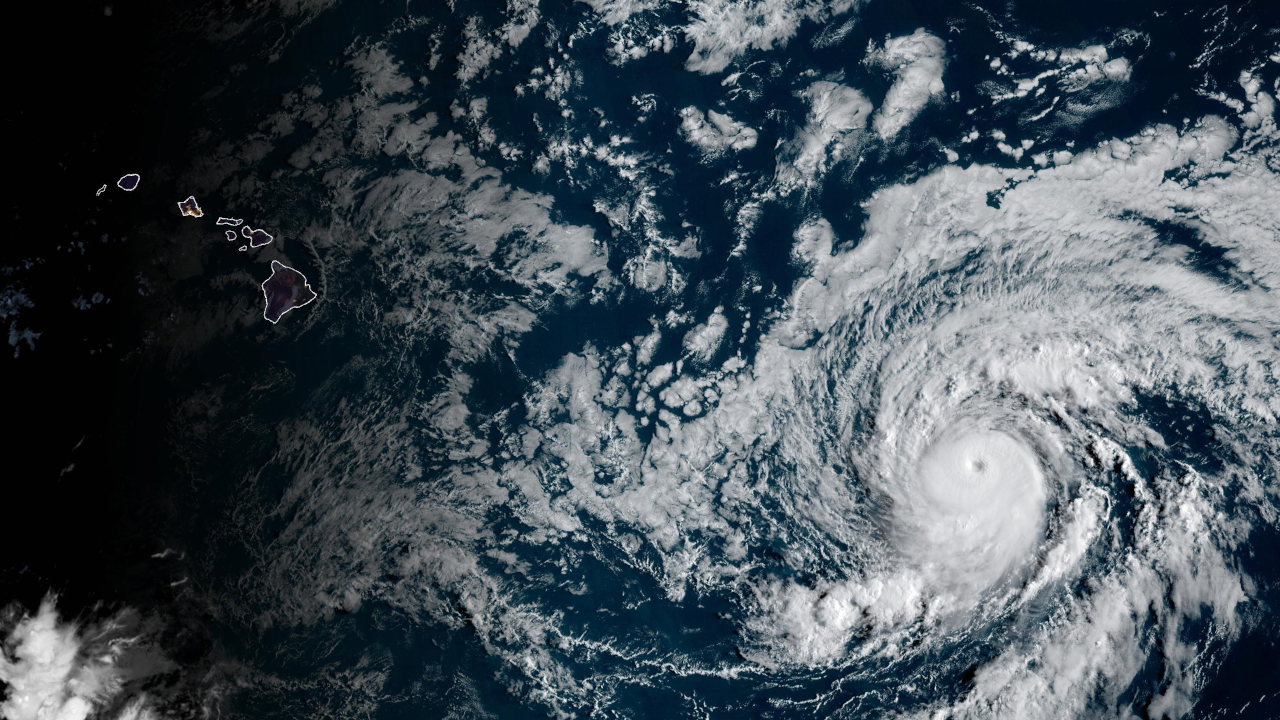
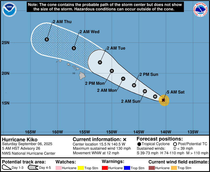
(BIVN) – Hurricane Kiko has entered the Central Pacific basin as a major hurricane, and as of 5 a.m. on Saturday was located about 1,000 miles east southeast of Hilo.
With maximum sustained winds near 130 mph, Kiko is a category 4 hurricane on the Saffir-Simpson Hurricane Wind Scale. Gradual weakening is expected over the next several days as it nears the Hawaiian Islands.
Kiko is moving toward the west-northwest near 12 mph, and the National Hurricane Center expects this general motion to continue for the next few days. The official forecast track keeps the center of Kiko north of the main Hawaiian Islands. However, “there is still some uncertainty in forecasts at 3 days and beyond,” the NHC says.
“Kiko is forecast to weaken as it approaches the Hawaiian Islands from the southeast and be a tropical storm as it passes in the vicinity of the far northern offshore waters of Hawaii Tuesday into Wednesday,” the National Weather Service in Honolulu reported Saturday morning. “A dry slot of air leading the cyclone will pass across the state Monday and briefly lower early day rain chances. Then rain chances will steadily increase from the east from late Monday through Wednesday or Thursday. Light trades will gradually back more northerly as TC Kiko passes off to the north through the middle of next week.”
“Kiko is also dragging in a very high precipitable water air mass of around 2 inches; near max values by early September standards,” the NWS added. “So, with a continued northerly track of Kiko, forecast confidence is highest that island weather during Kiko’s passage will transition to cloudier and more humid under very weak winds and occasional showers. The greatest rainfall will likely occur along more eastern and northern upslope, higher terrain exposures.”
Kiko’s main impacts will likely be marine-based. Surf along east facing shores will steadily rise late Sunday through early next week, forecasters say, as swell energy from Kiko arrives. “The surf may approach High Surf Advisory Criteria as early as Monday and possibly breach High Surf Warning levels Monday night into Tuesday during its peak,” the NWS said. “However, surf heights will be highly depended on the track and intensity of Kiko as it nears the state.”
From the National Hurricane Center discussion posted on Saturday:
Kiko is maintaining a well-defined eye on satellite imagery, but the convection is becoming eroded over the northern semicircle of the system. Also, the cloud tops have warmed somewhat since last night. The advisory intensity is set at 115 kt, in general agreement with Dvorak Current Intensity estimates from SAB and TAFB and close to the objective estimates from UW/CIMSS. Scatterometer data overnight showed that the system remains rather small, with tropical-storm force winds over a diameter of 100 n mi or less.
The hurricane continues on its west-northwestward trek with an initial motion estimate of 290/10 kt. Kiko is moving on the southwestern side of a mid-level ridge. A mid- to upper-level trough near Hawaii is eroding the ridge’s western periphery, so a a nearly northwestward motion is likely around 72 hours. Later in the forecast period, a more westward track is likely as the weakening cyclone becomes more responsive to the lower-level steering flow. The official forecast track is just slightly north of the previous official prediction, with some of the consensus track prediction aids even farther north of the latest official track. This would keep the center of Kiko north of the main Hawaiian Islands. However there is still some uncertainty in forecasts at 3 days and beyond.
Kiko is traversing SSTs near 26 deg C and should continue to pass over marginally warm ocean waters during the next few days. However, the trough near Hawaii is likely to impart increasingly strong south-southwesterly vertical wind shear over the cyclone for the next several days. The official intensity forecast shows gradual weakening, and is generally above the consensus model guidance. Simulated satellite imagery from the global models shows the deep convection becoming disorganized while the system passes near the Hawaiian Islands, so the official intensity forecast at 3-5 days could be generous.
An Air Force Hurricane Hunter aircraft is scheduled to investigate Kiko later today to provide a better look at Kiko’s intensity and structure.
Key Messages:
1. Kiko is forecast to approach the Hawaiian Islands during the early to middle portion of next week. Impacts from rain and wind are possible over portions of the Islands, but it is still too soon to determine the exact location or magnitude of these potential impacts, and interests there should continue to monitor the progress of this storm.
2. Swells generated by Kiko are expected to begin reaching the BiIsland and Maui by Sunday. These swells will gradually build and are forecast to peak along east-facing exposures of the Hawaiian Islands late Monday through midweek, potentially producing life-threatening surf and rip currents. Listen for later advisories and possible warnings from the National Weather Service.

by Big Island Video News
on at
STORY SUMMARY
HAWAIʻI - The center of Hurricane Kiko is expected to track north of the main Hawaiian Islands, however there is still some uncertainty in forecasts at 3 days and beyond.