(BIVN) – From this week’s Volcano Watch article, written by U.S. Geological Survey Hawaiian Volcano Observatory scientists and affiliates:
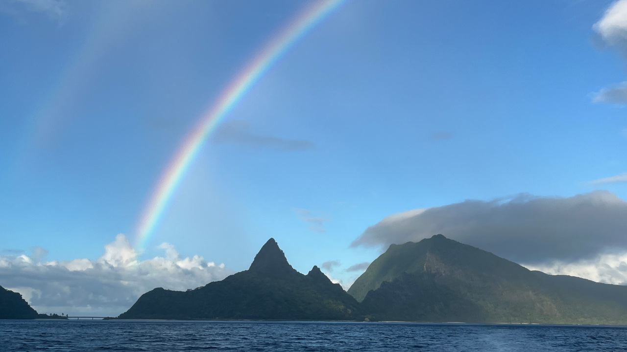
American Samoa is a United States territory which comprises the easternmost islands of a volcanic island chain formed by the Samoan hotspot in the South Pacific Ocean. Its small islands are the tops of volcanoes, and there is an active volcanic seamount nearby. The most recent eruption witnessed by local residents occurred in 1866, and submarine eruptions and earthquakes remind us that this region remains volcanically active.
American Samoa includes Tutuila Island (the main population center), Aunuʻu Island, and the Manuʻa Islands of Taʻū and Ofu-Olosega about 70 miles to the east. Vailuluʻu Seamount is about 30 miles east of the Manuʻa Islands on top of the Samoan hotspot, where submarine eruptions have occurred several times in the past few decades. Additionally, a near-shore eruption occurred east of Ofu-Olosega in 1866. Away from the Samoan hotspot, large earthquakes, sometimes greater than magnitude 8, can happen along the Tonga Trench, located about 150 miles (240 km) to the southwest of the Samoan archipelago.
An intense swarm of earthquakes was widely felt in the Manuʻa Islands from July 26th to October 2022, which led to an emergency declaration on August 8 by the American Samoa Department of Homeland Security. The NOAA National Weather Service (NWS) Weather Service Office at Pago Pago and USGS Hawaiian Volcano Observatory (HVO) deployed staff and resources to the Manuʻa Islands beginning August 13.
Prior to the swarm, American Samoa had no local earthquake monitoring, and the closest station was in the Independent State of Samoa, located about 150 miles (250 km) to the west of the Manuʻa Islands. HVO and NWS staff rapidly deployed local seismic sensors in the Manuʻa and Tutuila Islands, which revealed that hundreds of earthquakes per day were occurring about 10–15 miles (16–24 km) north of Taʻū Island. The data also showed that, along with the intense earthquake activity, molten magma was likely migrating into the area. Fortunately, the number and size of earthquakes declined significantly after August, ending the crisis.
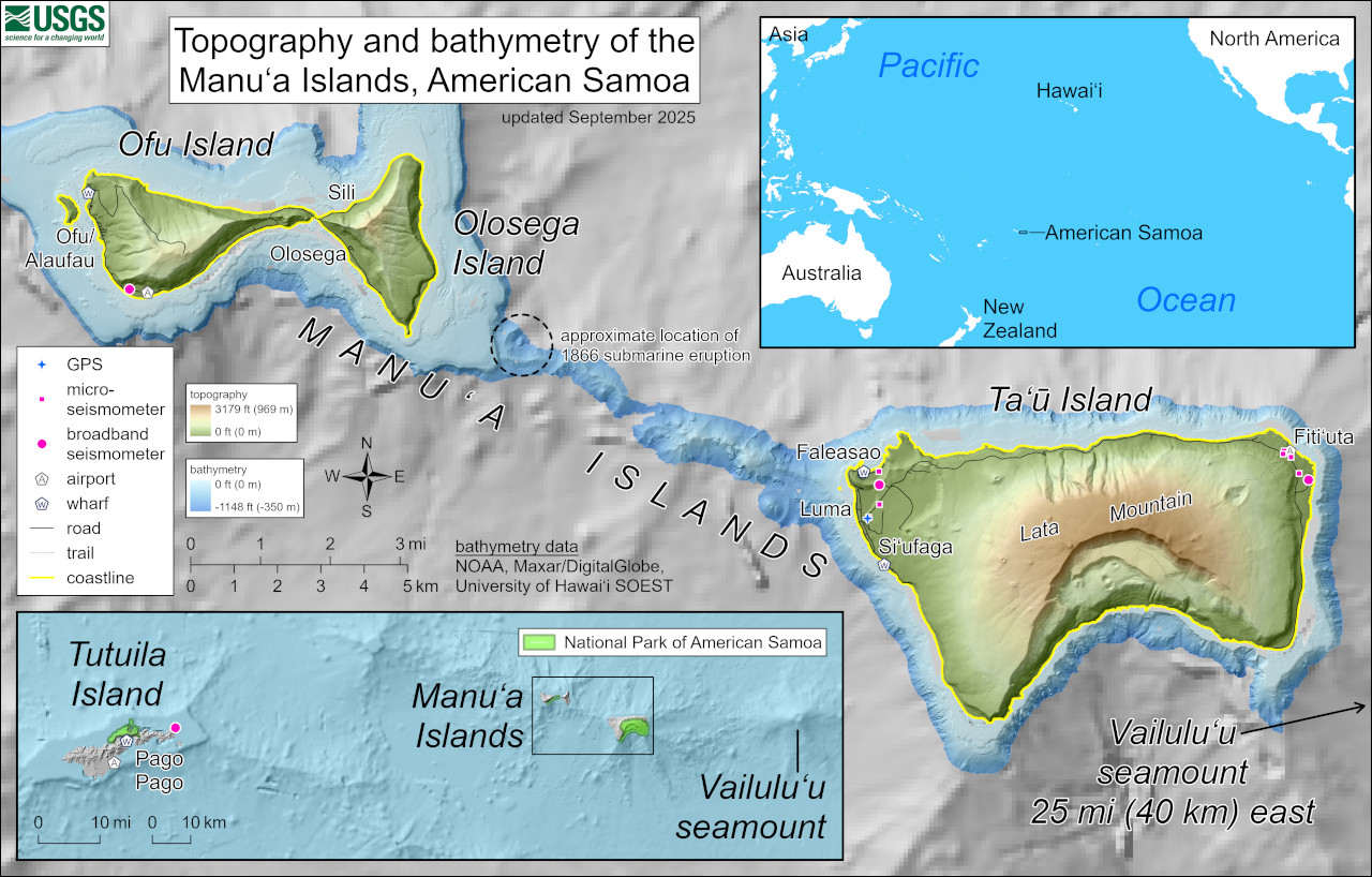
USGS: “This reference map depicts the volcanoes of the Manuʻa Islands, American Samoa, which are monitored by the USGS Hawaiian Volcano Observatory. Marked on the map are the locations of Hawaiian Volcano Observatory GPS and seismometers in the islands; the locations have been updated for network reconfigurations that occurred during site visits in early September 2025. The topography and bathymetry are colored to respectively indicate elevations above sea level (up to 3,179 feet or 969 meters, the top of Lata Mountain) and depths below sea level (only down to -1,148 feet or -350 meters). The bathymetry data are courtesy of the National Oceanic and Atmospheric Administration (NOAA), Maxar/DigitalGlobe, and the University of Hawaiʻi School of Ocean & Earth Science & Technology (SOEST), with coarser resolution at greater depths. A shallow submarine ridge extends to the northwest from Taʻū Island towards Olosega Island; it was along this ridge that a submarine eruption occurred in 1866.”
In the three years since, HVO and the USGS earthquake hazards program continue to actively assess the region for local volcanic and earthquake activity. All volcanoes in American Samoa are currently at USGS Volcano Alert Level/Aviation Color Code NORMAL/GREEN, meaning that these volcanoes are in background/non-eruptive states. Regionally, however, the Tonga Trench continues to produce numerous earthquakes, as is common for subduction zones. A recent example occurred on August 18, 2025, when a magnitude 5.5 earthquake was observed and located by the USGS.
In collaboration with NWS, HVO went to the Manuʻan Islands for joint outreach with the villages of Olosega, Ofu, Taʻū, Faleasao, and Fitiʻuta. Here, they met with teachers and community leaders to share information about the volcanoes of American Samoa; NWS shared information about tsunami, hurricanes, and other weather and marine hazards.
Between community meetings, they maintained and improved the monitoring network. There were two major initiatives. The first was getting a broadband seismic station—the gold standard for earthquake and volcano monitoring—back online in eastern Taʻū.
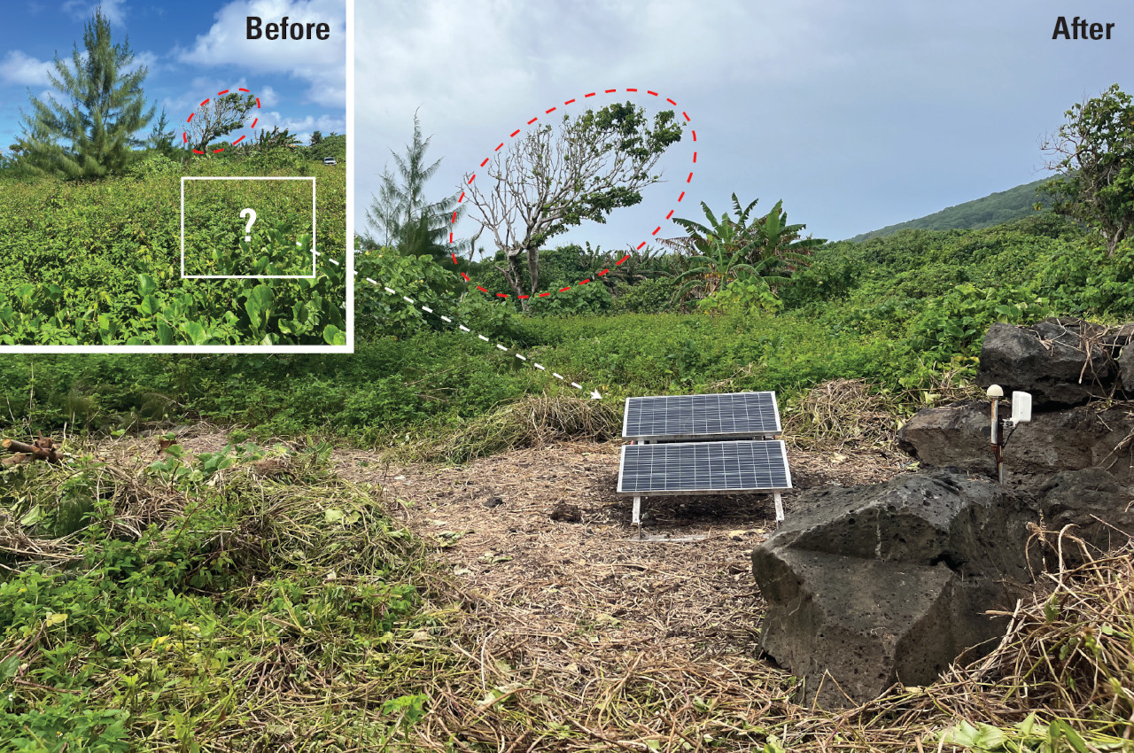
USGS: “Broadband seismometer site on eastern Taʻū, American Samoa, before (inset) and after a work party cleared rapidly growing vegetation which had covered the solar panels along with the boulders to the right of the main photo. Due to lack of power from the solar panels being unable to charge during the day, the station was offline for many months. To help with image comparison, the same tree is circled in both photos, and the box with the question mark inside on the inset is the approximate location of the solar panels. The prominent tree to the left in the inset was cut down; the stump is visible in the main photo.”
Unfortunately, in the past year, rapid vegetation growth covered the solar panels used to power the station. As a result, no data had been received for several months (thankfully, the network had enough working stations to be able to continue monitoring). A work party of HVO, NWS, American Samoa’s Territorial Emergency Management Coordination Office, and local residents removed vegetation from the site, allowing the station to provide service to the community once again. The loan of tools was greatly appreciated!
The second initiative was to replace sensors or install other new seismometers, used to supplement the broadband network. HVO thanks the American Samoan Department of Education, the Department of Homeland Security, ASTCA, and a handful of Manuʻa residents for hosting these seismometers.
After a successful trip to the Manuʻa Islands, HVO staff returned to Tutuila for further outreach, including attending the 4th Annual Disaster Resilience Summit. HVO plans to be back next year for another round of monitoring network maintenance, strengthening partnerships, and continuing to serve the people of American Samoa.
If you want to learn more about earthquake and volcano monitoring in American Samoa, please see this webpage: Volcanoes in American Samoa | U.S. Geological Survey.

by Big Island Video News
on at
STORY SUMMARY
SAMOA - The USGS earthquake hazards program continues to actively assess the region for local volcanic and earthquake activity.