
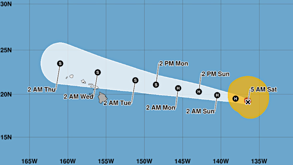

(BIVN) – As of Saturday morning, Hurricane Fausto is located 1,210 miles east of Hilo, heading west over the Pacific in the direction of the Hawaiian islands.
The National Hurricane Center says Fausto’s maximum sustained winds are near 100 mph (155 km/h) with higher gusts. Gradual weakening is forecast during the next several days.
“We’re keeping an eye on the system and will provide updates as we learn more about its track,” said Mayor Kimo Alameda in a Friday news release. “The storm is also a good reminder to make sure that you and your family are prepared this hurricane season.”
From the National Weather Service in Honolulu on Saturday morning:
A strong high pressure ridge remains locked in place north of the Hawaiian Islands, keeping easterly trade winds in the forecast through the end of next week. One exception to this trade wind weather pattern will develop early next week as Hurricane Fausto continues to track into the Hawaii region. Fausto remains on a high confidence east to west track towards the Hawaiian Islands based on the latest forecast from the National Hurricane Center.
Hurricane Fausto will likely weaken to tropical storm strength as the low center makes its closest point of approach near the Big Island on Tuesday and near Kauai by Wednesday. However, subtle shifts in the storms track or intensity may lead to significant forecast changes in island by island weather impacts. We strongly encourage the public to pay close attention to this passing storm system as weather impacts over the Hawaiian Islands early next week will likely evolve over time.
Potential Fausto Impacts Include…High surf above advisory thresholds along east facing shores from late Sunday through Tuesday, strong winds to around 40 MPH with stronger gusts may develop near and north of the low center and heavy rain threats are possible as Fausto moves from east to west across the region from Tuesday through Wednesday.
No time like the present to review your family hurricane preparedness plans, and ensure every household has at least a 14 day supply of food and water available if needed during this years active hurricane season.
From the National Hurricane Center discussion:
The recent satellite evolution of Fausto suggests the hurricane may have undergone an eyewall replacement cycle. The ragged eye of the hurricane has grown in size to about 30 n mi, while the inner eyewall convection decayed earlier this morning. A dry slot noted on the eastern side of the hurricane shows there are still pockets of dry air tangled up within the circulation, but for now the ring of deep convection surrounding the eye is closed. The initial intensity is held at 85 kt based on a blend of the latest Dvorak (77 kt) and objective (77-94 kt) estimates. A G-IV synoptic surveillance mission later today will sample the environment around Fausto.
Based on the structural changes of Fausto, small near-term intensity fluctuations are possible. However, all of the guidance continues to support gradual weakening over the next several days as Fausto moves over marginal sea-surface temperatures and into an even drier environment. In addition, Fausto will encounter increasing southwesterly shear while it approaches the Hawaiian Islands, which will displace the convection and strongest winds to the northern side of the circulation. No major changes have been made to the NHC intensity forecast, which follows the latest simple (IVCN) and corrected (HCCA) consensus aids. Fausto is predicted to be a weakening, sheared tropical storm when it passes near Hawaii.
The hurricane is moving westward at 12 kt along the southern periphery of a narrow subtropical ridge over the eastern and central Pacific. This feature should keep Fausto on a westward heading through the next several days, bringing the center into the central Pacific basin on Sunday and toward Hawaii early next week. The center of Fausto is forecast to make its closest approach to the Hawaiian Islands on Tuesday and Wednesday. The track guidance trended slightly northward this cycle, and the updated NHC track forecast has been nudged in that direction. While the current forecast brings the center of Fausto just to the north of the Hawaiian Islands, interests across the state should continue to pay close attention to forecast updates.
Key Messages:
1. Fausto is expected to weaken as it approaches the Hawaiian Islands early next week, but uncertainty remains regarding its exact track and intensity. While the current forecast brings the center just north of the islands, a track farther south would result in a greater risk of stronger winds and heavier rainfall. Interests across Hawaii should continue to monitor the progress of Fausto.
2. Confidence is high that swells generated by Fausto will reach the Hawaiian Islands well in advance of the cyclone, producing increasing surf and dangerous rip currents. Surf is expected to begin building across east-facing shores of the eastern end of the state on Sunday, spreading westward Sunday night into Monday, and continue building through Tuesday as Fausto approaches and moves into the area.
