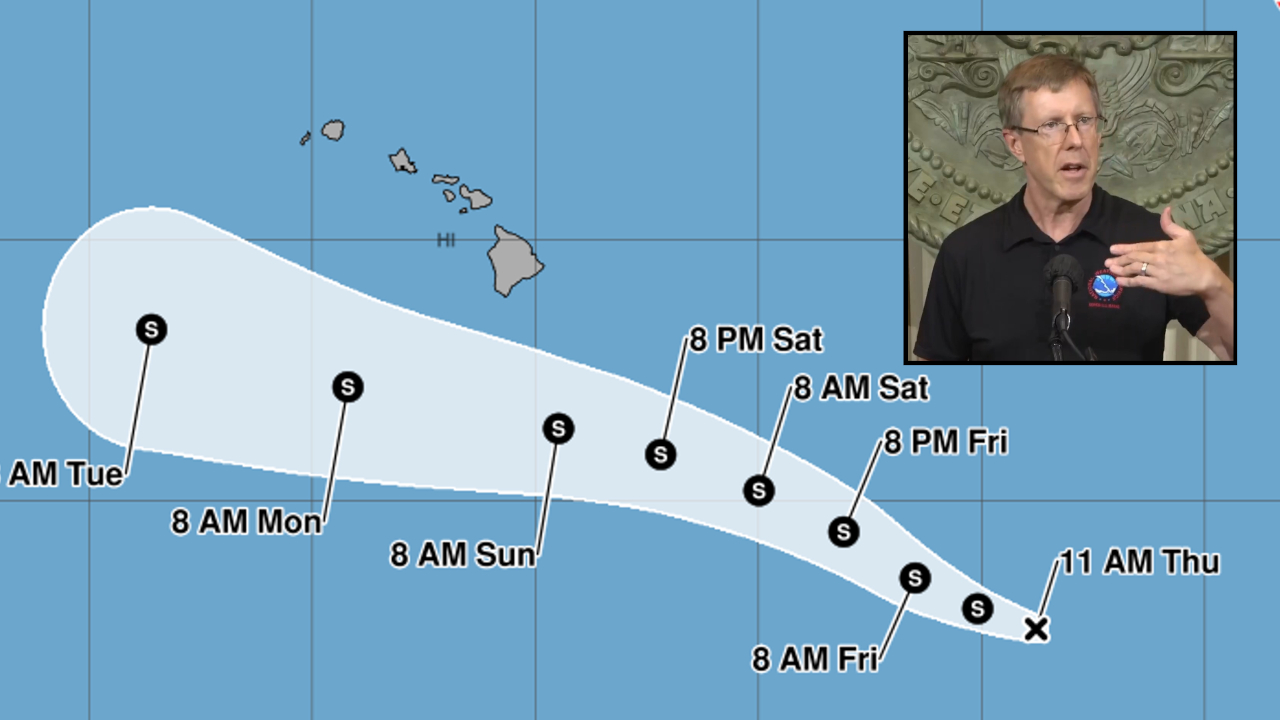
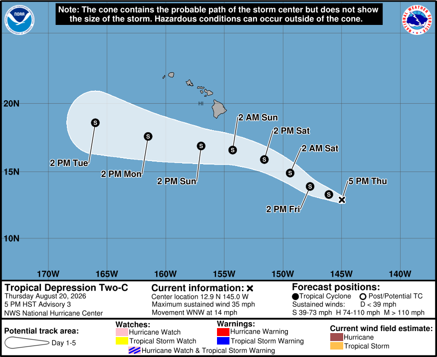
(BIVN) – Hawaiʻi State and County officials are getting prepared for another potential severe weather event, as Tropical Depression Two-C has formed in the Pacific and appears to be tracking just south of Hawaiʻi island.
As of 5 p.m. HST, the tropical depression was about 815 miles southeast of Hilo, and moving west northwest at 14 mph. Gradual strengthening is forecast over the couple of days, the Central Pacific Hurricane Center says, and the depression is expected become Tropical Storm Moke by tonight. Watches may be required for a portion of the Hawaiian Islands tonight or Friday.
“This is not the same as Lala,” stressed National Weather Service Warning Coordination Meteorologist John Bravender during a Thursday afternoon press conference. “Looks like the track is going to be a little further south and the windfield is not as large. So hopefully it won’t be as damaging.”
“However, there could be a lot of rain with it as well, especially for southeastern sections of the Big Island – the Kaʻū and Puna districts – that already had the most rainfall during Hurricane Lala, that could be impacted again,” Bravender added. “Even though rainfall amounts aren’t expected to be as large, given all the damage that we’ve had and the the repairs that people are still trying to accomplish right now, we’re concerned about the extra damage potential from this.”
The passing storm is expected to produce rainfall totals of 5 to 10 inches, with maximum amounts of 15 inches across the Big Island.
“Grounds in Hawaiʻi are very porous,” Bravender said. “They drain very fast, but they’re still wet. They’re still saturated. And with this rain, we could have more flooding damage. And that’s what we’re focused on going forward.”
“Lala tested our communities, but it also showed what Hawaiʻi can accomplish when government, nonprofits, businesses and neighbors work together,” said Governor Green. “As recovery continues and another system approaches, we are focused on both fronts: helping families get the support and resources they need now and ensuring our state is ready for what may come next. I am grateful to every responder, community partner, donor and individual resident, giving of themselves and stepping forward to support our people.”
“Our teams are coordinating closely with county emergency managers, the National Weather Service and response partners across the state while continuing recovery operations from Lala,” said Maj. Gen. Stephen Logan, Hawaiʻi adjutant general. “Residents should follow official updates, review their emergency plans and take practical steps now to protect their families. Early preparation gives our communities the best chance to stay safe.”
“We encourage everyone to take this new storm seriously and prepare for its expected arrival on Saturday,” said Hawaiʻi County Mayor Kimo Alameda in a news release. “The exact impacts aren’t clear, but that much rain falling on saturated ground could cause more flooding and landslides, so be prepared to move to shelter early.”
“The impacts from this storm could fall heavily across Puna and Ka‘ū, which are recovering from the flooding and wind damage caused by Lala,” said Darryl Oliveira, acting Administrator of Hawai‘i County Civil Defense. “Don’t wait for flooding to develop – if you are at risk, get to a safer shelter before the new storm arrives.”
From the Central Pacific Hurricane Center discussion posted 5 p.m. HST:
Satellite imagery indicates that the convection associated with Tropical Depression Two-C has weakened slightly during the past several hours, with most of the deep convection positioned over the western semicircle. The latest subjective Dvorak intensity estimates from JTWC and HFO remain T2.0/30 kt and are generally consistent with the objective intensity estimates. Therefore, the initial intensity is held at 30 kt. Both NOAA and Air Force reconnaissance aircraft are scheduled to investigate the cyclone on Friday.
The initial motion is estimated to be 290/12 kt, and this general motion is expected to persist into the weekend while the cyclone remains on the southern side of the subtropical ridge. A gradual turn toward the west is forecast later in the weekend as the ridge builds to the north of the system. Track guidance remains in generally good agreement, although some cross-track spread persists as the cyclone approaches and passes south of the Hawaiian Islands this weekend and into early next week. The updated NHC forecast reflects a blend of the previous forecast, ECMWF, and the GFS solutions, and generally lies near the northern side of the guidance envelope.
Environmental conditions appear favorable for gradual strengthening during the next few days. The cyclone is forecast to remain over warm waters and within an adequately moist environment while vertical wind shear remains relatively weak. These conditions should support steady intensification as the system approaches the vicinity of the Hawaiian Islands. Beyond about 72 h, increasing shear and a progressively drier surrounding environment should induce a weakening trend by early next week as it passes south of the Hawaiian Islands. The NHC intensity forecast shows the system becoming a strong tropical storm this weekend, followed by gradual weakening, and remains near the upper end of the intensity guidance.
Key Messages:
1. The tropical depression is expected to strengthen while it moves west-northwestward toward the vicinity of the Hawaiian Islands over the next couple of days.
2. Heavy rainfall associated with Tropical Depression Two will begin to impact the Big Island of Hawaii late Saturday night, spreading westward across the remainder of the Hawaiian Islands Sunday into Monday. This rainfall may produce life-threatening flooding and mudslides, especially in steep terrain and over areas that were affected recently by Lala.
3. There is a risk of wind and wave impacts in the Hawaiian Islands regardless of the exact track and intensity of the system. Watches may be required for portions of the Hawaiian Islands by Friday and residents should closely monitor the latest forecast updates and ensure that they have their preparedness plan in place.