
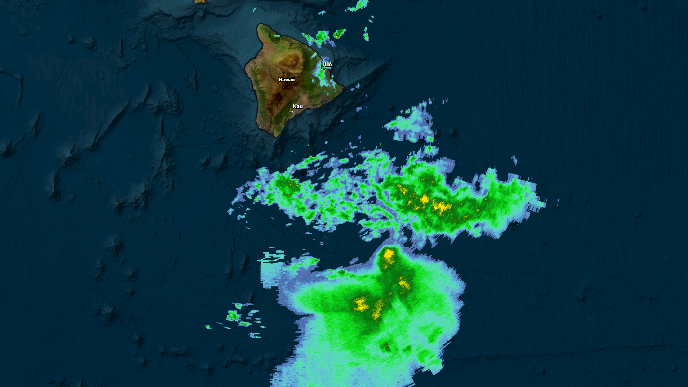

(BIVN) – A Flood Watch continues for Hawaiʻi island on Sunday morning, as Tropical Storm Moke is passing to the south of the islands.
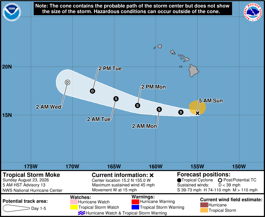
As of Sunday morning at 5 a.m., Moke was 310 miles south of Hilo, moving west at 15 mph.
The Central Pacific Hurricane Center says Moke has held steady in strength overnight, with maximum sustained winds maintained at 45 mph with higher gusts. Moke’s wind field has gotten smaller, with tropical-storm-force winds now extending outward up to 90 miles from the center of the storm.
Moke is forecast to lose some strength during the next few days as it passes south of the Hawaiian Islands.
The National Weather Service in Honolulu wrote this just before 4 a.m. Sunday morning:
Latest IR satellite loop shows deep convection from Tropical Storm Moke flaring up roughly 200 miles south southeast of Hilo. Low level clouds and moisture on the northern periphery of the cyclone can also be seen racing westward towards Big Island at a steady clip. Radar is picking on these bands and depicts scattered light to embedded moderate shower activity. Radar estimated rain rates remain unimpressive though, mainly below a tenth of an inch an hour. By early afternoon, the high resolution WRF-ARW, WRF-FV3, and namNest model guidance all indicate a rather stark increase in rainfall coverage and intensity along eastern portions of Big Island. It will not take a significant amount of rain to cause flash flooding due to saturated grounds from recent heavy rain from TC Lala. Thus, a Flood Watch will remain in effect for Big Island through Monday afternoon. Rainfall amounts for the event appear in good order, as NHC`s track for Tropical Storm Moke barely budged from the previous advisory package. Storm total forecast for windward and southeast Big Island remains at 5 to 10 inches with locally up to 15 inches, 3 to 6 inches for eastern Maui, and generally 1 to 2 inches elsewhere across the island chain.
Locally strong trade winds persisted overnight as Hawaii remained sandwiched between low pressure of Tropical Storm Moke south of the state and a 1025 mb surface high to the northeast. A Wind Advisory remains in effect through this evening for portions of Maui, Molokai, Lanai, Kahoolawe, and Big Island. Strongest sustained winds will continue to occur over mountain ridges, gaps and where winds blow downslope off higher terrain. Observed speeds in these areas have generally been sustained 25 to 35 mph with gusts up to 55 mph. Winds across the ridge tops of the Koʻolau and Waianae mountain ranges may near advisory criteria later today as trade wind showers and/or deeper moisture bands from the northern periphery of Moke begin to arrive. Those zones will be left out of the advisory for now, but may have to be included if the stronger winds expand further west. Trade winds across all islands should begin to ease back to moderate by tonight.
In a Sunday morning radio message, the Hawaiʻi County Civil Defense repeated the list of available shelters at following locations:
- Yano Hall in Captain Cook
- Nāʻālehu Elementary School
- Pāhala Senior Center
- Robert Herkes Gym in Pāhala
- Keaʻau Armory, and
- Puʻueo Community Center in Wainaku
From the Central Pacific Hurricane Center discussion at 5 a.m. HST:
Moke continues to pulse some convection in the northern semicircle, though much of the southern portion of the storm is exposed due to persistent shear. The initial intensity is held at 40 kt given little change in the overall organization of the cyclone during the past several hours. This is also in agreement with earlier aircraft data and close to recent Dvorak estimates.
The storm is expected to move through a challenging environment during the next several days, with plentiful mid-level dry air and moderate shear in its path. These conditions will likely beat out the warm sea-surface temperatures, and Moke should struggle to produce sustained deep convection in this regime. Shear is forecast to increase in 2-3 days, and the storm is expected to weaken into a tropical depression or remnant low around that time. The new forecast is a bit lower than the last one late in the period and shows an earlier transition to a post-tropical cyclone. It should be mentioned that more models are now showing the system opening up into a trough of low pressure even earlier than shown below due to the harsh environment and Moke’s forward speed.
Moke is moving westward at about 13 kt, wobbling a bit as convective bursts briefly pull the system north of due west. A general west-northwestward motion is anticipated during the next several days as a strong low- to mid-level ridge remains to the north of the cyclone. This track should bring the center of Moke a couple of hundred miles south of the Big Island today and then well south of the rest of the main Hawaiian Islands thereafter. The model guidance is a bit south of the last forecast, and the NHC track is moved in that direction. Despite the center of Moke remaining south of the Hawaiian Islands, the cyclone is expected to pass close enough to produce a period of gusty winds and heavy rainfall across portions of the islands during the next couple of days.
Key Messages:
1. Heavy rainfall associated with Tropical Storm Moke will begin to impact the Big Island of Hawaii today. Rain will then spread westward across the remainder of the Hawaiian Islands through Monday. This rainfall may produce life-threatening flooding and mudslides for the windward and southeast Big Island, especially in steep terrain and over areas that were affected recently by Lala.
2. Although the strongest winds associated with Moke are expected to pass south of the Hawaiian Islands, strong gusty winds are likely, particularly in areas within and downslope of higher terrain.
