
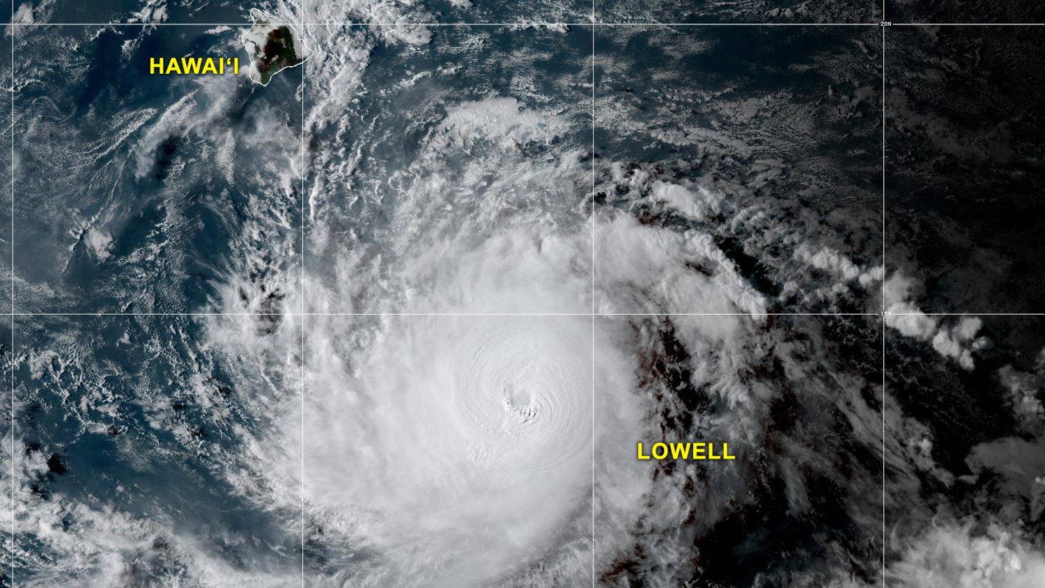

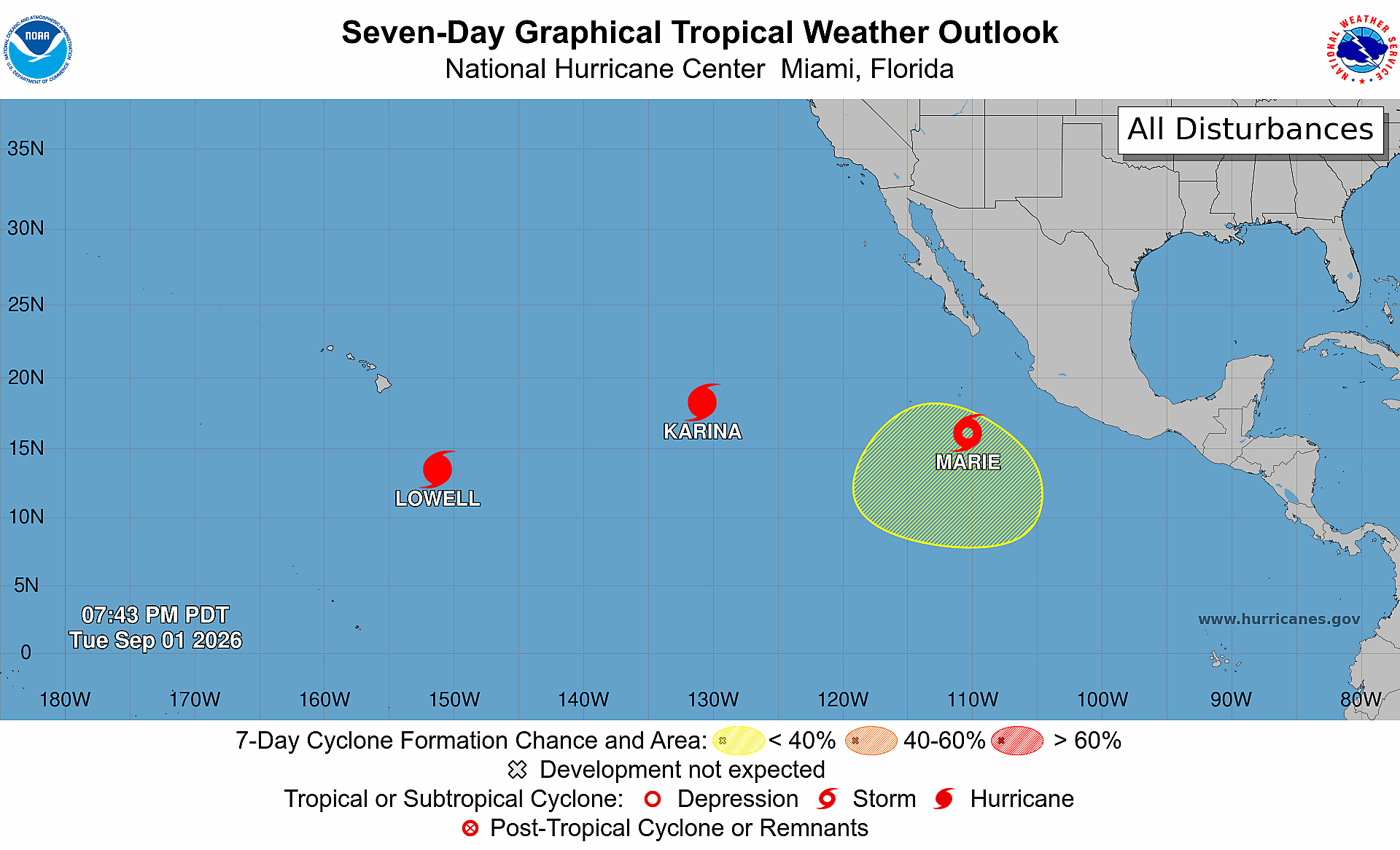
(BIVN) – Three tropical cyclones are gathering strength as they move westward over the Pacific Ocean.
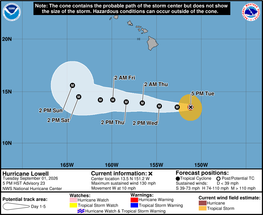
The closest storm to Hawaiʻi is Lowell, a category 4 hurricane on the Saffir-Simpson Hurricane Wind Scale, which makes it a major hurricane. As of 5 p.m. on Tuesday, Lowell was 500 miles south-southeast of Hilo, moving west at 10 mph.
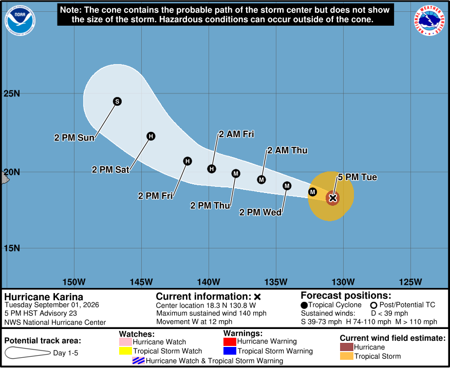
Behind Hurricane Lowell is Hurricane Karina. Karina is even stronger, with 140 mph winds. Karina gained strength on Tuesday but is expected to gradually weaken going forward.
Tropical Storm Marie was 470 miles south of the southern tip of Baja California as of Tuesday evening. Marie is expected to become a hurricane on Wednesday.
The National Weather Service on Tuesday said “models continue to show a spread of possible solutions for the tracks of Hurricanes Lowell and Karina.”
The Honolulu-based forecasters said Lowell is currently forecast by the National Hurricane Center to “continue traveling just north of due west through Saturday before beginning to turn more northwest.”
Models indicate that Hurricane Lowell “may turn sharply north at some point, most likely when well west of the main islands,” the NWS stated. “However, some models indicate the possibility of an earlier turn which may bring it near or over one of them.”
Karina is forecast by the National Hurricane Center to move west-northwest through Friday, then begin a more northwest track into the weekend. “This track will take it north of the state,” the National Weather Service said.
“A very few models (out of hundreds) bring it west far enough to move into the main islands,” the Honolulu forecasters noted. “Although odds are good that neither storm will directly strike populated islands, it would be wise to stay aware of new forecasts in the coming days.”
The National Weather Service added that Tropical Storm Marie “is approximately 10 days away from potentially moving near Hawaiʻi, and will not be discussed in depth at this time.”
In the coming days, winds are expected to increase over Hawaiʻi, due to an increasing surface pressure gradient with high pressure to the north, and Hurricane Lowell to the south. Flooding rains are not expected with the passing storm, and fire weather watches are not anticipated due to forecasted high humidity values.
Along Hawaiian shores, Lowell has the potential “to be a significant source of south to southwesterly swell through this weekend and into next week depending on how sharply and quickly the cyclone turns to the north.”
From the Central Pacific Hurricane Center discussion on Hurricane Lowell at 5 p.m. HST:
Lowell’s satellite presentation continues to improve, characteristic of a rapidly intensifying cyclone. Deep, cold convection is wrapping around a fluctuating eye on infrared and visible satellite imagery. Over the past few hours, lightning activity has also increased within the eyewall. Objective and subjective satellite intensity estimates continue to rise as they attempt to catch up with the ongoing rapid intensification. The latest subjective Dvorak estimate from HFO was T5.5, but was constrained, with a Data-T of 6.0/115 kt. Based on these estimates and the continued improving satellite trends, the initial intensity is set at 115 kt for this advisory.
Lowell remains within a favorable environment characterized by warm sea surface temperatures and low vertical wind shear. The system is likely to continue strengthening and is expected to remain a major hurricane throughout the remainder of the forecast period. However, fluctuations in intensity are possible due to internal structural changes, such as eyewall replacement cycles. Based on current conditions and recent trends, the official NHC intensity forecast remains near the upper end of the guidance suite.
The initial motion is westward, or 275/9 kt. A westward to west-northwestward motion should continue throughout much of the forecast period as Lowell is steered by a mid-level ridge located to the north. The official track forecast has once again been adjusted slightly southward during this time frame, trending closer to the HCCA and GDMI track aids. Toward the end of the forecast period, track uncertainty increases. An upper-level trough approaching from the west is forecast to move north of the Hawaiian Islands, weakening the aforementioned ridge. This evolution will cause Lowell to decelerate and begin turning toward the northwest or north late in the period. Interests in the Hawaiian Islands should continue to closely monitor Lowell’s progress.
Key Messages:
1. Interests in the Hawaiian Islands should continue to closely monitor the progress of Hurricane Lowell.
From the National Hurricane Center discussion on Hurricane Karina at 5 p.m. HST:
The infrared satellite presentation for Karina has improved over the last several hours as the cloud tops have cooled down to around -70 degrees Celsius. Based on the presentation from the infrared and analysis from the SHIP guidance, Karina has developed annular characteristics. However, the eye still remains cloud filled at this time. The current satellite intensity estimates range from 114 to 129 kt. Therefore, the initial intensity for this advisory has been brought up to 120 kt.
The major hurricane is moving westward at about 9 kt. A general slow westward to west-northwestward motion is expected during the next 3 to 4 days as a narrow mid-level ridge remains situated to the north of the hurricane. During the weekend, a turn to the northwest seems likely as the ridge shifts eastward and the cyclone approaches a mid- to upper-level low north of Hawaii. The current NHC forecast track is very similiar to the previous one with only small adjustments in speed and is slightly to the right of the previous track. The current official forecast track continues to keep the hurricane to the north of the Hawaiian Islands.
In the short term, the hurricane has the opportunity to intensify a bit, however, in the long run, the environment will become less favorable for Karina due to cooler ocean waters and decreasing relative humidity. With Karina developing annular characteristics the rate of weakening is expected to be slower at first. The current NHC intensity forecast shows a bit of strengthening within the first 12 h, and then a gradual weakening for 24 to 60h. Past 60 h, the rate of weakening should increase as the low- to mid-level relative humidity drops below 40%.
