
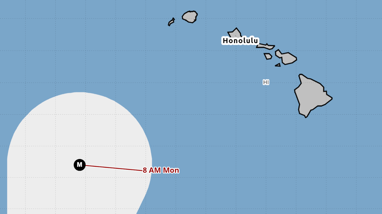

(BIVN) – There is a possibility that a major hurricane could impact the State of Hawaiʻi next week. An uncertain forecast shows Major Hurricane Lowell taking a sharp turn to the north after passing the islands to the south this week.
“The details of Lowell’s long-range track and intensity forecasts are more uncertain than usual, and it is too soon to determine potential impacts in the Hawaiian Islands,” the Central Pacific Hurricane Center stated at 5 p.m. on Wednesday. “Interests in Hawaii should continue to closely monitor the progress of Lowell through this upcoming weekend.”
“This is a good time for all residents to ensure they have their hurricane plan and supply kit in place,” the forecasters said.
Earlier today, Lowell was reported to be a category 5 hurricane, but has since been downgraded slightly to a category 4. Lowell was 440 miles south of Hilo as of 5 p.m., and moving west at 10 mph.
Lowell is expected to continue in this direction while maintaining major hurricane status over the next few days.
Swells generated by Lowell are spreading northward and will affect portions of the Hawaiian Islands during the next several days. A High Surf Advisory is currently in effect for south and southeast-facing shores.
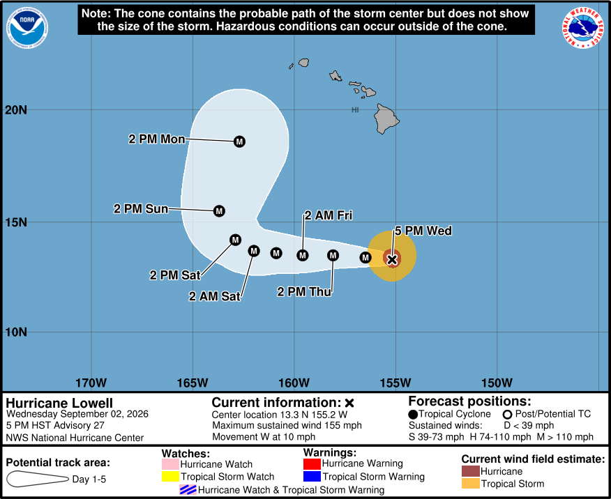
From the Central Pacific Hurricane Center discussion on Hurricane Lowell posted at 5 p.m. HST:
Since the last advisory, Lowell’s satellite signature has decayed, with the cloud tops in the eyewall warming and the eye becoming less distinct. This has been accompanied by a decrease in satellite intensity estimates. A NOAA Hurricane Hunter aircraft has reported 700-mb flight-level winds of 135 kt and a minimum central pressure near 932-933 mb. Based on these data and continuity from the previous advisory, the initial intensity is reduced to a possibly generous 135 kt. Satellite imagery gives the impression that the hurricane is being affected by easterly shear. However, if this is the case, the source of the shear is a bit mysterious, as the available shear diagnostics show shear of less than 10 kt.
The initial motion is now 270/9 kt. Currently, Lowell is being steered by a low- to mid-level ridge to the north, and due to this the hurricane should continue moving westward for the next 2-3 days. After that, the track of the hurricane will be controlled by a developing mid- to upper-level trough or low currently seen in water vapor imagery near 32N 164W. During the next several days, the global models forecast this feature to move eastward or southeastward toward the Hawaiian Islands, then turn westward to the north of Lowell. While this will break down the ridge north of Lowell and allow it to turn northward, there is a wide spread of possibilities of when and where this turn will occur. The model consensus has again shifted a little eastward at day 4-5, and the new forecast track is again nudged a little eastward at these times.
The hurricane is expected to stay in a favorable environment of high oceanic heat content and low shear for at least the next three days. However, the intensity guidance calls for slow decay during this time despite the favorable environment. Based on this, the intensity forecast also calls for slow decay. It is likely, though, that eyewall replacement cycles will cause fluctuations in intensity superimposed on the slow decay. Near the end of the forecast period, Lowell should start experiencing increasing shear caused by the upper-level trough, and a more pronounced weakening may begin around day 5. There remains high confidence that Lowell will remain a major hurricane through the weekend.
KEY MESSAGES:
1. The details of Lowell’s long-range track and intensity forecasts are more uncertain than usual, and it is too soon to determine potential impacts in the Hawaiian Islands.
2. Interests in Hawaii should continue to closely monitor the progress of Lowell through this upcoming weekend. This is a good time for all residents to ensure they have their hurricane plan and supply kit in place.
3. Swells from Lowell are likely to cause life-threatening surf and rip current conditions in portions of the Hawaiian Islands during the next several days. Depending on the exact track of the storm, these swells are likely to increase early next week.
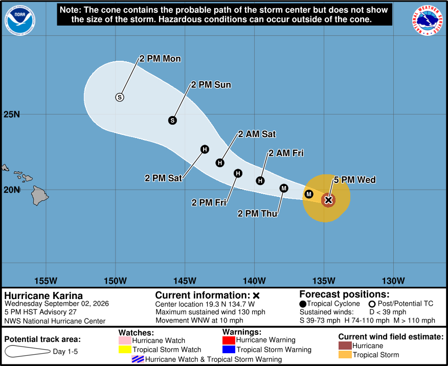
Meanwhile, Hurricane Karina was located 1,325 miles east of Hilo as of 5 p.m. Wednesday. Karina is also a category 4 hurricane on the Saffir-Simpson Hurricane Wind Scale, with maximum sustained winds near 130 mph.
The National Hurricane Center expects Karina to head west- northwest through Friday, before lifting further to the north over the weekend and weakening.
From the National Hurricane Center discussion on Hurricane Karina issued at 5 p.m. Wednesday:
Latest infrared satellite imagery of Karina suggests that convective cloud-top temperatures continue to warm. Karina continues to maintain an annular appearance, while the eye remains cloud-filled. The latest TAFB subjective Dvorak intensity estimate held steady from 18z to 00z, at 5.5/6.5 or 127 kt. Objective intensity estimates from CIMSS vary around 105-110 kt. Given the warming cloud-top temperatures over the last several hours, the initial intensity estimate was adjusted down slightly to 115 kt.
Karina is currently moving west-northwestward around 9 kt. A subtropical ridge to the north of Karina should cause the cyclone to continue moving west-northwestward for the next couple of days. Karina is then expected to turn more northwesterly later this week as the subtropical ridge is weakened by an oncoming upper-level trough. Karina’s track forecast was nudged slightly to the east of the previous forecast, reflecting a blend of HCCA and GDMI. Models exhibit relatively strong agreement in Karina’s track through the first 48 h, before spread increases thereafter.
While vertical wind shear is expected to remain very weak over the next 48 h, Karina is expected to track toward cooler SSTs and into a drier mid-level environment. The latest NHC intensity forecast shows a slightly faster rate of weakening than the previous forecast, but still lies at the high end of the guidance envelope for the first 3 days, and then closer to the intensity consensus at days 4 and 5. The hostile environmental conditions should cause Karina to lose its convection and become post-tropical by day 5.
