
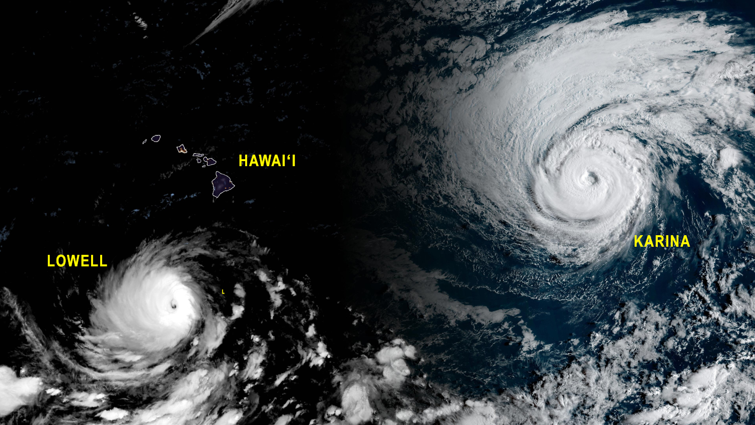

(BIVN) – Confidence has been increasing that Major Hurricane Lowell will take a northward jog as it passes south of Hawaiʻi, possibly impacting portions of the state early next week.
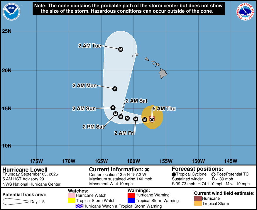
As of 5 a.m. on Thursday morning, Hurricane Lowell was located 450 miles south-southwest of Hilo, moving west at 10 mph. Maximum sustained winds are near 140 mph, making Lowell a category 4 hurricane on the Saffir-Simpson Hurricane Wind Scale.
Lowell is expected to remain a major hurricane as it takes a sharp turn to the north this weekend.
“While it is still too soon to determine the exact track of the hurricane, Lowell could bring storm surge, wind, and rainfall impacts to portions of Hawaii early next week,” the National Weather Service stated this morning. “Interests in Hawaii should continue to closely monitor the progress of Lowell through the upcoming Labor Day weekend, listen to the advice of officials, and ensure they have their hurricane plan and supply kit in place.”
From the Central Pacific Hurricane Center discussion on Hurricane Lowell issued at 5 a.m. HST:
Lowell is still a powerful hurricane with a warm eye that is apparent in infrared and proxy-visible satellite images. Overnight WSF-M passive microwave data showed some thinning of the convection in the eastern portion of the eyewall, possibly the result of some intrusion of drier mid-level air. However, recent conventional satellite imagery shows colder cloud tops and a slightly thicker ring of convection surrounding the center. Based on a blend of the Dvorak current intensity (CI) estimates from JTWC and HFO, the initial intensity is set at 120 kt for this advisory. The 34-kt wind radii were expanded, particularly on the north side of the hurricane, based on overnight scatterometer data. Another NOAA aircraft research mission into Lowell is scheduled for later today.
The hurricane will move over warm waters while in a weaker shear environment during the next few days. These conducive environmental and oceanic conditions favor Lowell maintaining its major hurricane intensity, even as internal structural changes like eyewall replacement cycles commence. Since these types of changes are extremely difficult to predict, the NHC intensity forecast follows a similar approach as the previous prediction and shows no net change through the end of the week (though some small fluctuations are expected). By the weekend, southwesterly vertical wind shear is forecast to increase over Lowell, which should induce some weakening along with a more asymmetric wind structure.
Lowell is being steered westward (270/9 kt) by a mid-level ridge to its north over the Central Pacific. A continued westward motion is expected during the next couple of days. Then, the forecast becomes more challenging as a mid- to upper-level trough over the northern Pacific digs southward and erodes the steering ridge. This will cause Lowell to turn sharply northward or north-northeastward this weekend and then accelerate generally toward the north early next week, passing near or west of the westernmost main Hawaiian Islands by day 5. The updated NHC track forecast lies between the corrected (HCCA) and simple (TVCN) track consensus aids, showing a sharper turn at days 3-4 but similar to the previous NHC prediction at day 5. Remember that the average track errors at days 4-5 are around 150 n mi and 200 n mi, respectively. There is lower confidence in the long-range track forecast details, and future adjustments may be required. Residents in Hawaii should closely monitor the latest NHC forecast updates.
KEY MESSAGES:
1. Lowell could be at or near major hurricane strength when it moves near the westernmost main Hawaiian Islands late Monday and Monday night. While it is still too soon to determine the exact track of the hurricane, Lowell could bring storm surge, wind, and rainfall impacts to portions of Hawaii early next week.
2. Interests in Hawaii should continue to closely monitor the progress of Lowell through the upcoming Labor Day weekend, listen to the advice of local officials, and ensure they have their hurricane plan and supply kit in place.
3. Swells from Lowell are likely to cause life-threatening surf and rip current conditions in portions of the Hawaiian Islands during the next several days. These swells are likely to increase early next week.
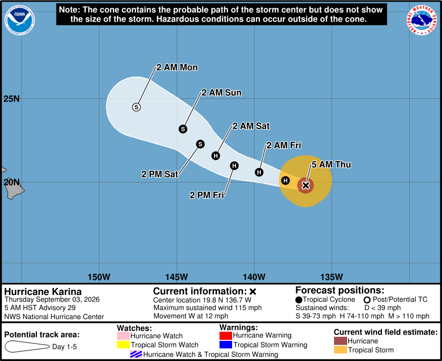
Meanwhile, Hurricane Karina was located about 1,195 miles east of Hilo as of 5 a.m. Thursday. The storm, with maximum sustained winds near 115 mph, is moving west at 12 mph.
From the National Hurricane Center discussion on Hurricane Karina issued at 5 a.m. HST:
Little has changed in Karina’s annular appearance over the last several hours. The latest subjective Dvorak analysis from TAFB gave an intensity estimate of 102 kt, while objective estimates from CIMSS ranged from 90-95 kt. Given the continued downward trend across subjective and objective Dvorak analysis, the initial intensity estimate was set at 100 kt.
Karina’s initial motion was set at 280/9 kt. The system is forecast to shift more west-northwest over the next couple of days, as it continues to be guided by a subtropical ridge to its north. By late this weekend into early next week, an oncoming upper-level trough is expected to pull Karina more to the northwest, away from the main Hawaiian Islands. The official track forecast was little changed from the previous advisory, with only slight adjustments westward to reflect a blend of HCCA, GDMI, and the previous official track forecast.
A steady weakening trend in Karina’s intensity is still expected to occur as the system encounters an increasingly drier mid-level environment. After 24 h, Karina’s weakening trend is forecast to hasten as vertical wind shear increases and SSTs decrease, with the system expected to become post-tropical by Day 4. The official intensity forecast increases the rate of weakening compared to the previous advisory, falling just above most model guidance within the first 24 h before landing closer to guidance consensus thereafter.
