
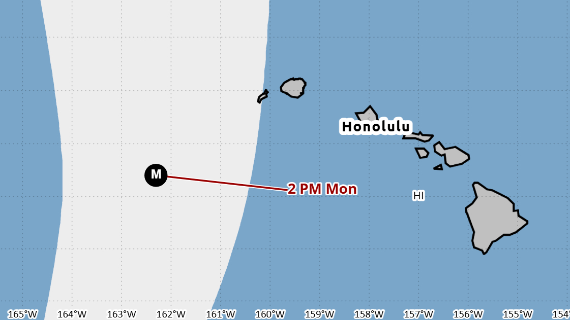

(BIVN) – As of 5 p.m. Thursday evening, Hurricane Lowell was located 495 miles south-southwest of Hilo, and slowly moving west at 9 mph. Reports from a NOAA Hurricane Hunter aircraft indicate that maximum sustained winds are near 130 mph (215 km/h) with higher gusts, making Lowell a low-end category 4 hurricane on the Saffir-Simpson Hurricane Wind Scale and a major hurricane.
Hawaiʻi officials are closely monitor the progress of Lowell, expecting the storm to turn to the north, and speed up, at some point over the weekend.
“Attention will shift late Sunday into early next week to the forecast track of Hurricane Lowell, currently a category 4 hurricane,” the National Weather Service in Honolulu stated on Thursday afternoon, saying the National Hurricane Center track forecast “moves Lowell slowly westward through Friday night with an abrupt northward turn and increase in forward speed on Saturday.”
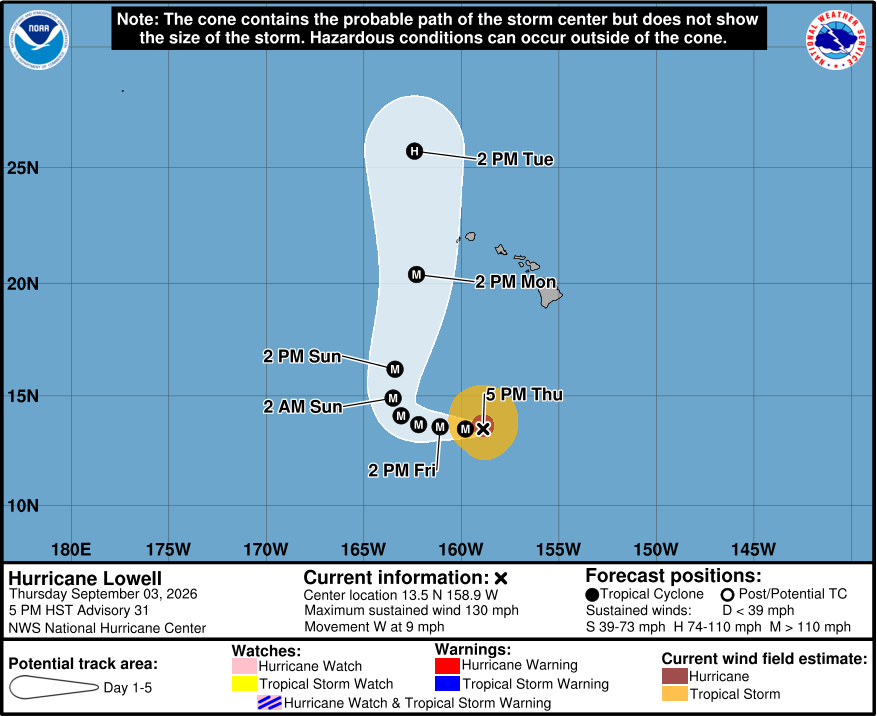
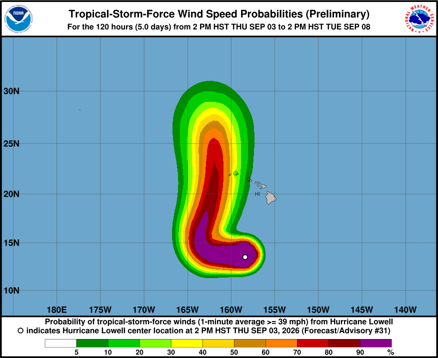
“While confidence is low whether a direct impact will occur or not, Lowell will likely bring some impacts to the state including storm surge, high surf, wind, and rainfall impacts to portions of Hawaiʻi, particularly as it moves closest to Kauai County Monday night,” the Honolulu-based forecasters said. “The extent of these impacts could range from minor to major depending on the eventual path of the storm, and more specifically when the abrupt turn to the north occurs. Regardless, Lowell is forecast to be a category 3 hurricane at its closest proximity.”
The National Weather Service added coastal inundation could also be exacerbated by the peak monthly high tides that are expected to occur Monday.
“Interests in Hawaiʻi should continue to closely monitor the progress of Lowell through the upcoming Labor Day weekend, listen to the advice of officials, and ensure they have their hurricane plan and supply kit in place,” the forecasters cautioned.
State officials are planning on holding a press conference on the approaching storm on Friday.
From the Central Pacific Hurricane Center discussion on Hurricane Lowell posted at 5 p.m. HST:
Lowell’s cloud pattern has lost a little organization since the last advisory, with the eye becoming clouded over at the top and the eyewall convective tops becoming warmer and less symmetric. A NOAA Hurricane Hunter aircraft reported maximum 700-mb flight-level winds of 116 kt, and data from the onboard radar showed winds near 125 kt at 0.5 km above the surface. The central pressure was near 943 mb. Based on the aircraft data, the initial intensity is reduced to a possibly generous 115 kt. Earlier microwave data suggested the possibility that Lowell was undergoing an eyewall replacement cycle (ERC), and the aircraft flight-level winds showed an outer wind maxima in the northwestern semicircle. However, the only recent microwave overpass was a partial hit that did not help resolve whether the ERC was completing or not.
Lowell remains in a generally favorable environment of high oceanic heat content and light shear, and these conditions should persist during the next three days or so. This could allow some re-intensification after the ERC completes, and some of the intensity guidance shows strengthening between 24-48 h. The new intensity forecast will do likewise and shows some modest strengthening during this time. Starting at 72 h, Lowell is expected to encounter increasing southwesterly shear that should cause a substantial weakening. However, it is still forecast to be at or near major hurricane strength when making its closest approach to the Hawaiian Islands.
Lowell continues westward with an initial motion of 270/8 kt. The ridge is forecast to weaken during the next couple of days due to a developing mid- to upper-level trough north of the Hawaiian Islands, which is reflected in a forecast slower forward speed. After 48 h, the trough will likely create a break in the ridge that should cause Lowell to turn northward by 72 h and accelerate northward to north-northeastward after 72 h. This track would bring the center of Lowell near or just west of the westernmost main Hawaiian Islands late Monday into early Tuesday. The track guidance is more tightly clustered than it was 24 h ago, and the track guidance envelope has changed little since the last advisory. Based on this, the new forecast track is similar to the previous track with only noise-level changes. However, the long-range track details are still of lower confidence, and residents in the Hawaiian Islands should closely monitor the latest NHC forecast updates.
KEY MESSAGES:
1. Lowell could be at or near major hurricane strength when it moves near the westernmost main Hawaiian Islands late Monday and Monday night. While it is still too soon to determine the exact track of the hurricane, Lowell could bring storm surge, wind, and rainfall impacts to portions of Hawaii early next week.
2. Interests in Hawaii should continue to closely monitor the progress of Lowell through the upcoming Labor Day weekend, listen to the advice of local officials, and ensure they have their hurricane plan and supply kit in place.
3. Swells from Lowell are likely to cause life-threatening surf and rip current conditions in portions of the Hawaiian Islands during the next several days. These swells are likely to increase early next week.
