
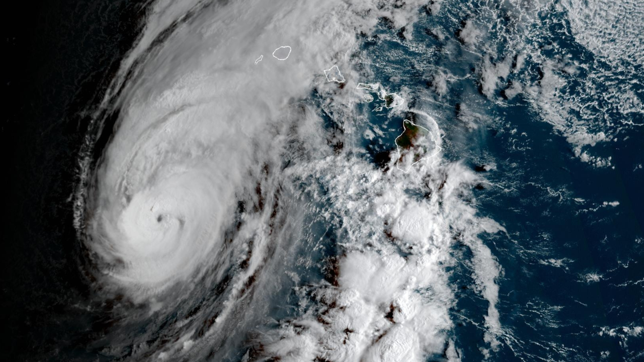

(BIVN) – As of 8 a.m. on Monday morning, Hurricane Lowell was 325 miles south-southwest of Lihue, travelling north-northeast at a faster 15 mph.
On the forecast track, the core of Hurricane Lowell is expected to pass near or just west of Niʻihau tonight and early Tuesday. Lowell is then forecast to turn toward the northwest and slow down by early Wednesday after passing the Hawaiian Islands.
A Hurricane Warning is in effect for Kauai County, including the islands of Kauai and Niʻihau. A Hurricane Warning is also in effect for the Papahanaumokuakea Marine National Monument from Nihoa to French Frigate Shoals.
This morning, a Tropical Storm Warning was issued for Oʻahu.
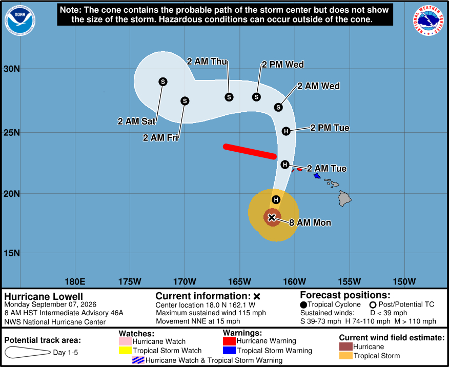
As of 8 a.m., Lowell was a category 3 hurricane on the Saffir-Simpson Hurricane Wind Scale, with maximum sustained winds near 115 mph, making it a major hurricane. Lowell is expected to gradually weaken through Tuesday, but is forecast to remain a hurricane as it passes near the Hawaiian Islands.
Hurricane conditions are expected in Kauai County beginning this afternoon or evening.
The Central Pacific Hurricane Center says Lowell “is expected to produce additional rainfall totals of 6 to 10 inches for Kauai, with maximum totals of 16 inches possible. For the Big Island, 4 to 8 inches of rain is expected with isolated totals of 12 inches possible. For Oahu and Maui county, 4 to 8 inches of rain is expected with isolated totals of 10 inches possible. This rainfall may produce significant flash flooding and mudslides, especially across Kauai county and portions of the Big Island.”
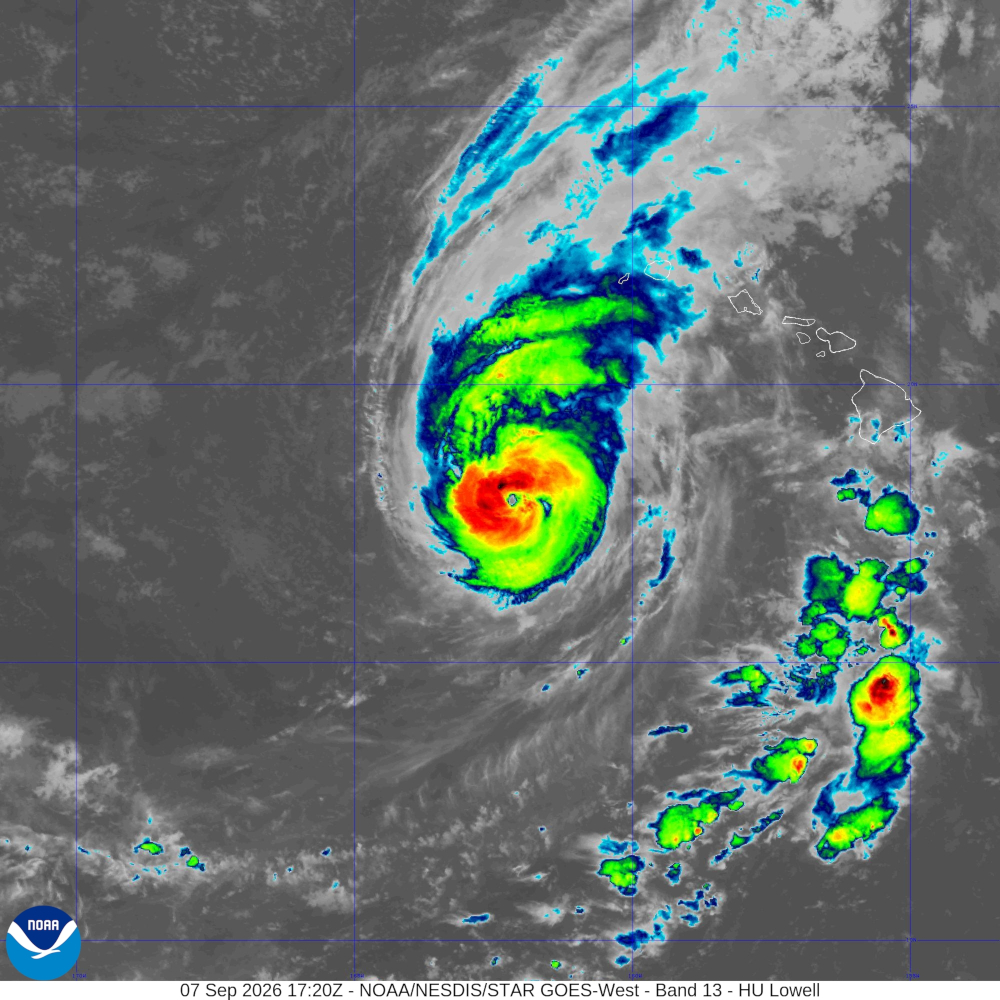
Several tornadoes are possible near Kauai and Niʻihau this afternoon through tonight, forecasters warn. A few tornadoes are also possible across the remainder of the Hawaiian Islands.
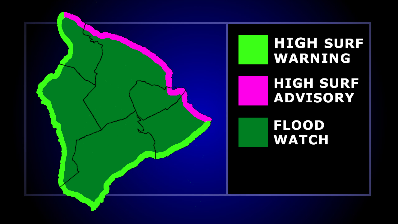
Hawaiʻi island is under a Flood Watch, as well as a High Surf Warning for south and west facing shores from North Kohala down to Puna. A High Surf Advisory is in place for East Hawaiʻi. Kona shores could see surf of 6 to 8 feet rapidly building Monday afternoon, reaching 12 to 16 feet by evening.
All westside County beach parks remain closed.
From the Central Pacific Hurricane Center on Monday at 5 a.m. HST (prior to the Tropical Storm Warning issued for Oʻahu):
Lowell is a well-organized hurricane with a distinct eye and cold cloud tops in the eyewall, though overnight microwave imagery still showed evidence of concentric eyewalls. Intensity estimates are about the same as 6 hours ago, so the initial wind speed is held at 100 kt. Another Air Force Hurricane Hunter aircraft is scheduled to be in the cyclone in a few hours for a better estimate.
The initial motion is north-northeastward or 025/12 kt. A cut-off mid- to upper-level low is slowly moving westward to the north- northwest of Hawaii, which should allow the storm to gradually bend more to north during the next 24 hours. However, this northward turn has been delayed from expected, and the guidance has shifted about 30 n mi to the east of the last forecast. NHC’s new forecast follows that trend, bringing the hurricane closer to the western Hawaiian Islands. The new forecast necessitates a Tropical Storm Watch for Oahu, and any further eastward adjustments could require a warning later today or this afternoon. Beyond 2 days, Lowell should swing westward as it merges with the upper-low, a few hundred miles north of the northwestern Hawaiian Islands. The forecast is shifted westward at long range, and the system could be close to dissipating as a tropical cyclone on day 5 based on the latest global model forecast.
Lowell is starting to encounter increasing shear and cooling waters, which should cause a gradual weakening today, though it is still expected to be a large hurricane as it passes near or just west of Niihau. Rapid weakening is in the forecast after it moves north of the main Hawaiian Islands due to very strong shear and marginal water temperatures. Model guidance is in poor agreement in the medium range due to the upper-level trough interaction, and little change is made to the last forecast at long range.
KEY MESSAGES:
1. The core of Lowell is forecast to pass near or just west of Niihau tonight and early Tuesday, and damaging hurricane conditions are expected to begin in Kauai County tonight and continue through Tuesday morning, with tropical storm conditions expected to begin later today. Higher wind gusts are expected atop mountains and on windward and leeward slopes.
2. Periods of heavy rainfall will increase in coverage over the Hawaiian Islands today and continue through Wednesday. This may produce significant flash flooding and mudslides, especially across Kauai county and portions of the Big Island.
3. Large damaging waves are expected to impact exposed portions of Kauai County and are likely to produce coastal flooding and inundation of low-lying areas through early Tuesday.
4. Large swells will produce life-threatening surf and rip current conditions across the remainder of the Hawaiian Islands during the next several days.
