
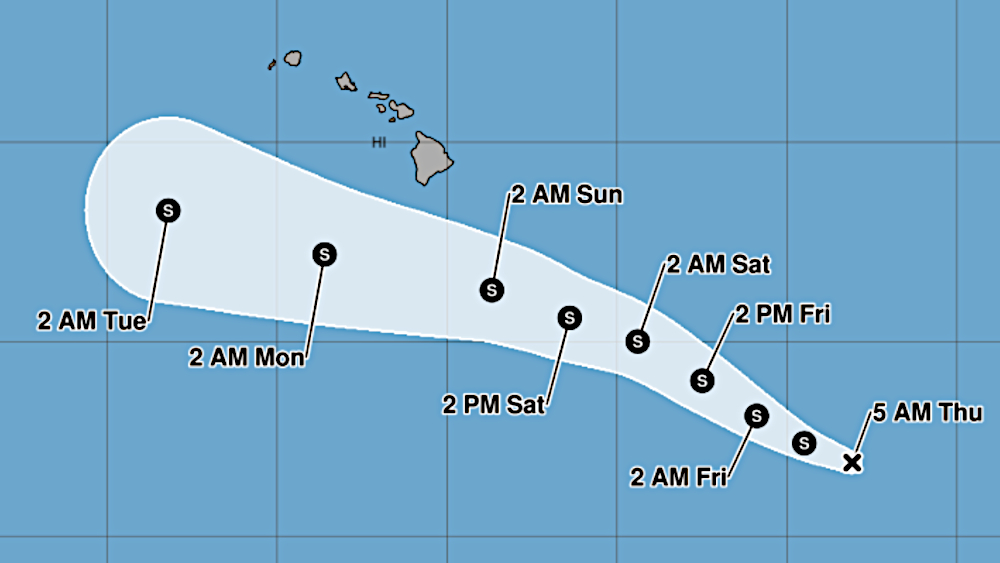

(BIVN) – The tropical disturbance to the southeast of Hawaiʻi island has become a tropical depression, and forecasters have produced the first forecast track for the potential tropical storm.
Tropical Depression Two-C has formed, about 960 miles east southeast of Hilo. The storm is currently moving west northwest at 16 mph.
Two-C is expected to strengthen into a tropical storm later today, and pass near or south of Hawaiʻi island this weekend.
“Interests in the Hawaiian Islands should closely monitor the progress of this system,” the National Hurricane Center stated. “Watches may be required for a portion of the Hawaiian Islands tonight or Friday.”
“The first look at the potential track keeps the storm south of the Big Island, but it is still early in the forecast process and the track could shift either north or south in coming advisory cycles,” the National Weather Service in Honolulu stated on Thursday morning. “Impacts from rain, wind, and surf can be experienced well outside the center of the storm so do not focus too much on the exact track. Current guidance indicates that precipitation will increase on the east side of the state Saturday night into Sunday, spreading west Sunday night into Monday. The timing, direction, and magnitude of the strongest winds remain highly dependent on the track and intensity of the system.”
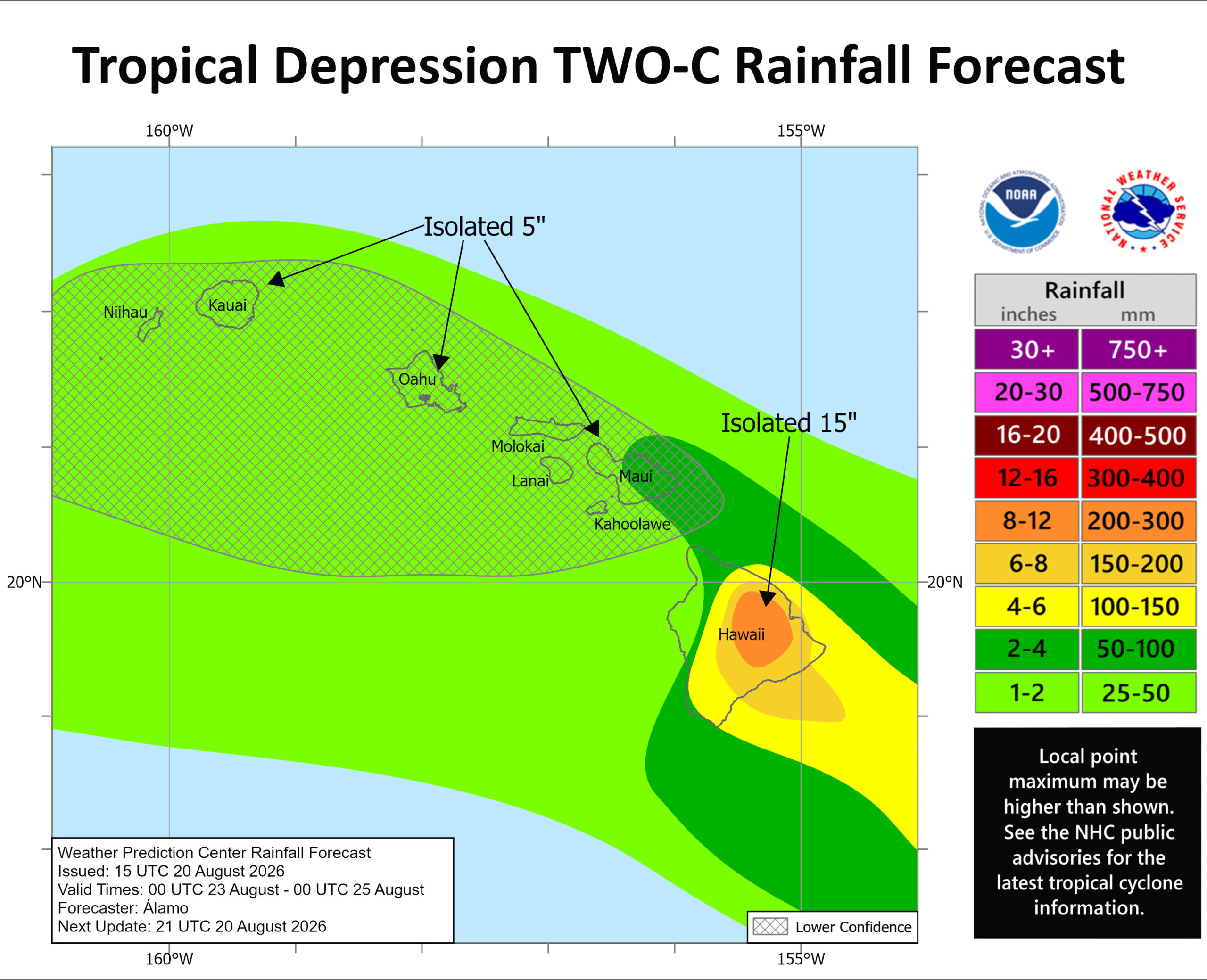
Areas on Hawaiʻi island, still recovering from the devestation of Hurricane Lala, could see another 15 inches of rain, forecasters say.
Governor Josh Green is expected to hold a news conference today on the potential incoming storm.
From the Central Pacific Hurricane Center at 5 a.m. HST:
The system that NHC has been monitoring (invest 90E) over the central Pacific now has developed a sufficient amount of convective organization that has been steadily increasing over the last several hours. In addition, the low-level circulation has been getting better defined, as evident in satellite data, therefore the system now meets the criteria of a tropical cyclone. The ASCAT pass from last night shows that the circulation is located near the eastern edge of the convection and generally supports an initial intensity of about 30 kt.
The system appears to be moving west-northwestward at about 14 kt, and that motion is expected to persist for the next 48 hours or so until the ridge north of it strengthens. This steering flow is expected to force the system to turn more toward the west in a few days. The current NHC track lies on the northern side of the guidance envelope, but there is some uncertainty in the details in regards to the strength of the ridge and a nearby trough. It is important to note that the NHC track error at 72 h is about 75 n mi, and interests in the Hawaiian Islands, especially the Big Island, should monitor the progress of this system.
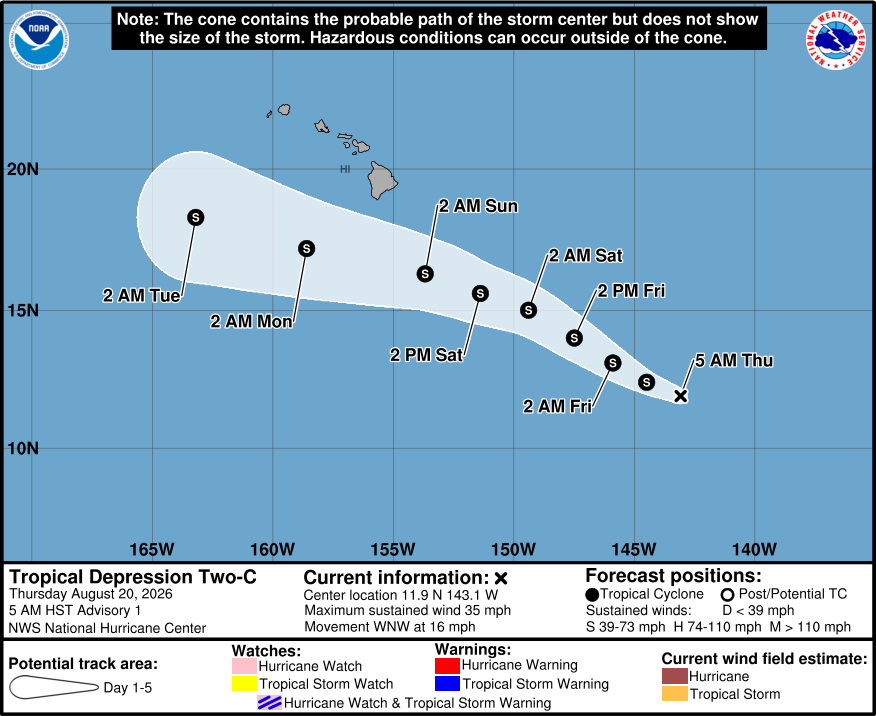
The cyclone is expected to be in a mostly favorable environment for the next couple of days, which should allow for gradual strengthening to a high-end tropical storm or a category one hurricane as the system moves toward the Hawaiian Islands. Beyond that time, wind shear will likely start to increase and dry air will also begin to to intrude into the cyclone. The current NHC intensity forecast calls for a peak wind speed of 60 kt this weekend, with gradual weakening occuring after that. This forecast lies near the high end of the model guidance.
Key Messages:
1. The tropical depression is expected to strengthen while it moves west-northwestward toward the Hawaiian Islands late this week and this weekend. Although it is too soon to specify the exact location and magnitude of impacts, residents should closely monitor the latest forecast updates and ensure that they have their preparedness plan in place.
2. Heavy rainfall associated with Tropical Depression Two-C is expected to begin to impact the Big Island of Hawaii late Saturday night, spreading westward across the remainder of the Hawaiian Islands Sunday into Monday. This rainfall may produce life-threatening flooding and mudslides, especially in steep terrain and over areas that were affected recently by Lala.
3. There is a risk of wind and wave impacts in the Hawaiian Islands regardless of the exact track and intensity of the system Watches may be required for portions of the Hawaiian Islands tonight or Friday.
