
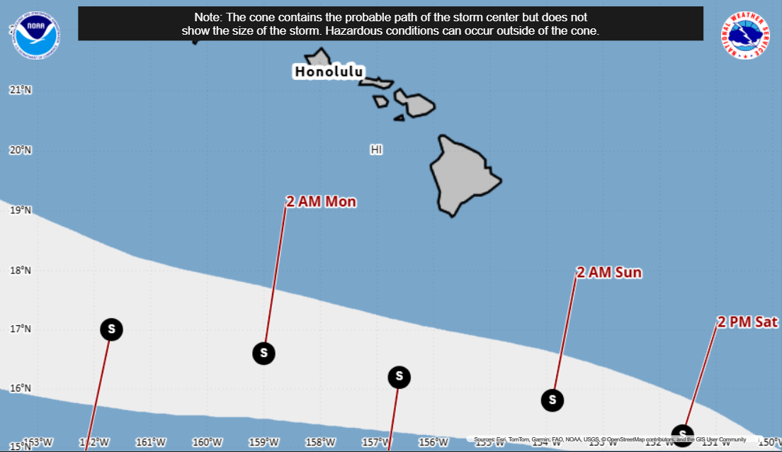

(BIVN) – Tropical Storm Moke, which formed on Friday from what was once Tropical Depression Two-C, continues to track south of Hawaiʻi island.
As of 5 p.m. on Friday, Tropical Storm Moke was just under 600 miles southeast of Hilo, and moving west-northwest at 12 mph.
Moke’s maximum sustained winds are near 45 mph (75 km/h) with higher gusts. Gradual strengthening is forecast over the next day or two, as “the center of the storm is expected to pass south of the Big Island of Hawaii this weekend, then south of the smaller main Hawaiian Islands early next week,” the Central Pacific Hurricane Center says.
Moke is expected to produce rainfall totals of 5 to 10 inches across the Big Island, with maximum amounts of 15 inches possible. A Flood Watch has been issued for Hawaiʻi island.
Due to Tropical Storm Moke, the Hawaiʻi County Civil Defense advised:
- Hawaii Island residents and businesses, please take this time to prepare for possible bad weather.
- If you are in a flood prone area or if you concerned that your location may be unsafe, please consider relocating to a safer location.
- Shelters will be designated at a later time and locations will be provided to the community in future messages.
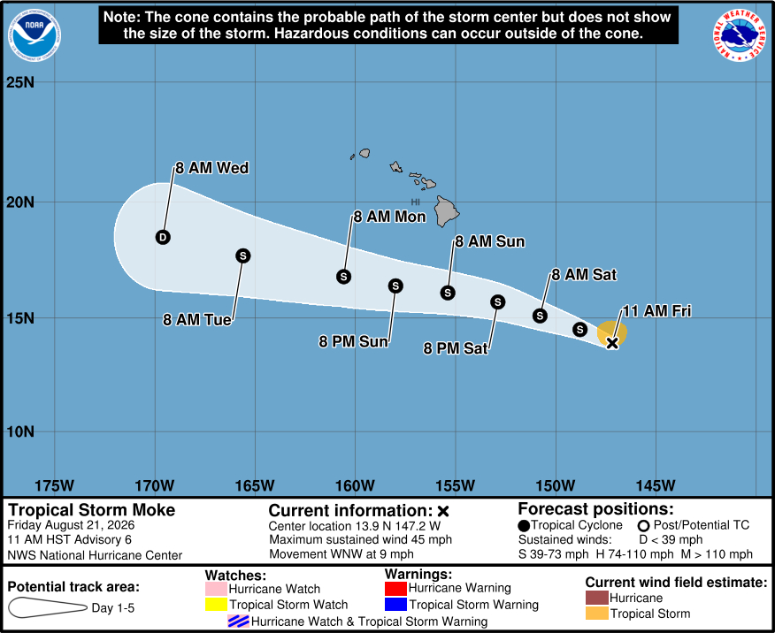
From a 5 p.m. discussion by the Central Pacific Hurricane Center:
Moke has changed little in organization over the past several hours. Moderate southwesterly vertical wind shear continues to impart a slight northward tilt to the vortex, as indicated by Tail Doppler Radar data, with most of the deep convection displaced north of the low-level circulation center. Data from NOAA and Air Force Reserve Hurricane Hunter aircraft support an initial intensity of 40 kt and a minimum central pressure of 999 mb. Based on these observations and the overall satellite presentation, the initial intensity is held at 40 kt for this advisory.
Moke is moving west-northwestward, or 295/10 kt. There has been little change to the track forecast philosophy. A low- to mid-level ridge is forecast to strengthen north of Moke during the next few days, which should steer the cyclone west-northwestward at a slightly faster forward speed. This motion is expected to take the core of Moke south of the main Hawaiian Islands this weekend into early next week. The latest track guidance remains fairly tightly clustered, and the NHC forecast is similar to the previous advisory. Given the expected track south of the islands and the compact nature of the cyclone, the likelihood of tropical storm watches or warnings for the main Hawaiian Islands remains very low. However, the enhanced pressure gradient north of Moke, combined with moisture associated with the cyclone interacting with the island terrain, will likely produce gusty winds and periods of heavy rainfall across portions of the state. These impacts could be aggravated by antecedent conditions from Lala last weekend, particularly in areas where soils remain saturated.
Some additional strengthening is possible during the next day or so while Moke remains in generally favorable environmental conditions. Thereafter, dry mid-level air is expected to become increasingly entrained into the circulation while vertical wind shear increases late this weekend into early next week. These factors should cause Moke to gradually weaken as it passes south of the Hawaiian Islands. The latest NHC intensity forecast is similar to the previous advisory and remains near the upper end of the guidance envelope.
Key Messages:
1. Heavy rainfall associated with Moke will begin to impact the Big Island of Hawaii late Saturday, with rain spreading westward across the remainder of the Hawaiian Islands Sunday into Monday. This rainfall may produce life-threatening flooding and mudslides for the windward and southeast Big Island, especially in steep terrain and over areas that were affected recently by Lala.
2. Although the strongest winds associated with Moke are expected to pass south of the Hawaiian Islands, strong gusty winds are likely, particularly in areas within and downslope of higher terrain.
3. Swells generated by the storm may cause life-threatening surf and rip current conditions this weekend and early next week for exposed east and south facing shores of the Hawaiian Islands.
