
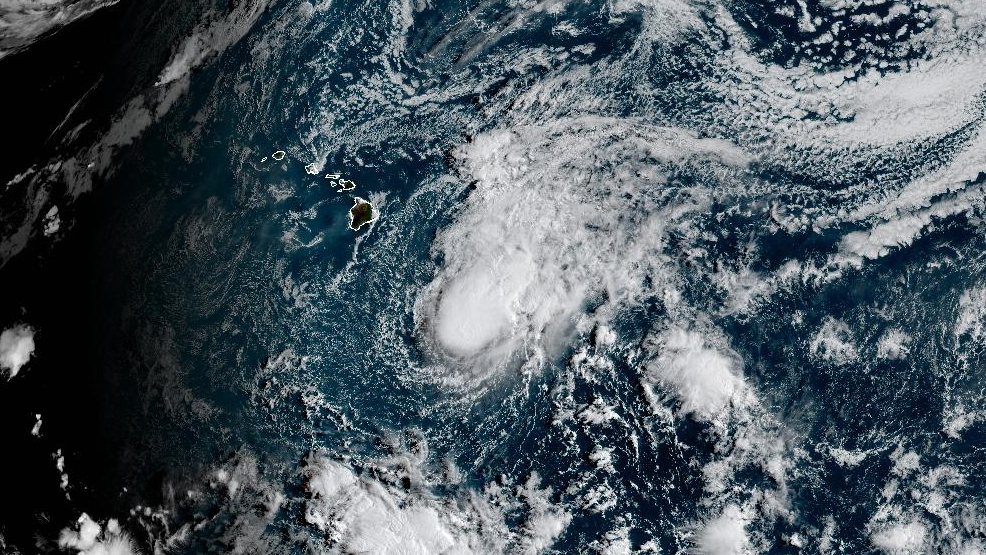

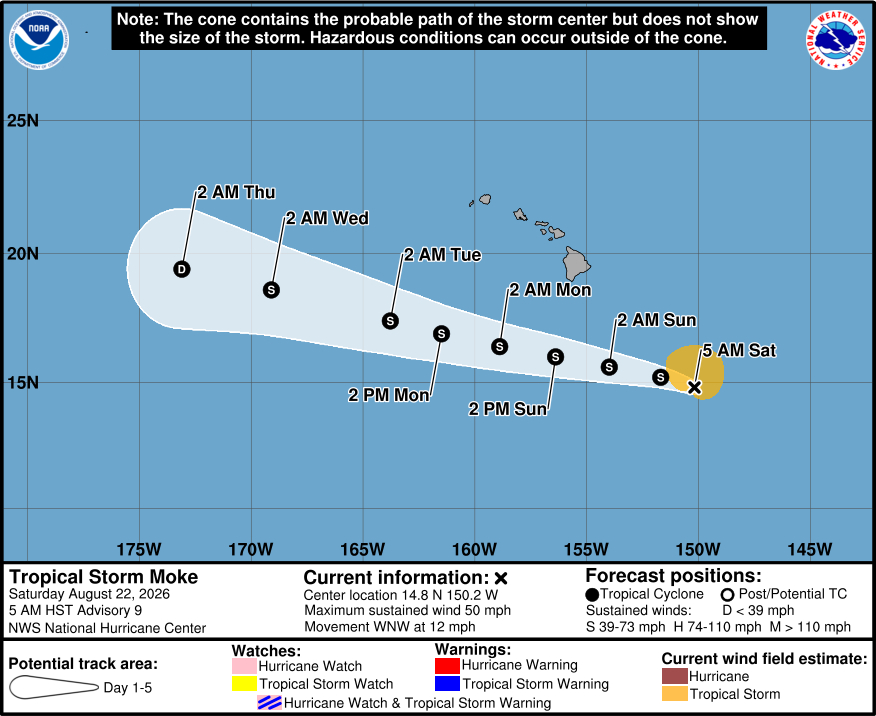
(BIVN) – Tropical Storm Moke was 470 miles southeast of Hilo on Saturday morning, moving west-northwest at 12 mph.
Overnight, Moke has gotten slightly stronger. Maximum sustained winds have increased to near 50 mph (85 km/h) with higher gusts. Tropical-storm-force winds extend outward up to 115 miles from the center.
Additional strengthening is expected today, as the center of the storm is forecast to pass south of Hawaiʻi island tonight and early Sunday.
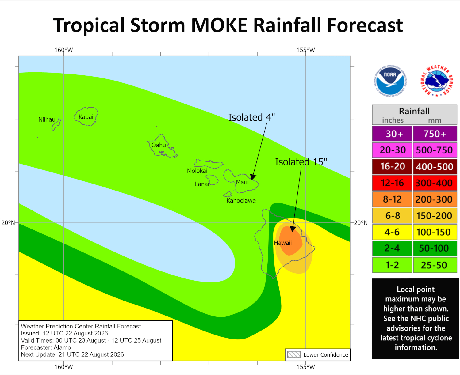
The Central Pacific Hurricane Center is still expecting Moke to produce heavy rains over Hawaiʻi island, with totals of 5 to 10 inches – and maximum amounts of 15 inches – possible. “This rainfall may produce life-threatening flooding and mudslides for the windward and southeast Big Island, especially in steep terrain and over areas that were affected recently by Lala,” the forecasters stated. A Flood Watch is in effect for the island.
Forecasters also expect to see gusty winds across the Hawaiian Islands tonight and Sunday, especially in areas of high terrain. A Wind Advisory has been added for areas of Hawaiʻi island. East northeast winds of 25 to 35 mph, with gusts up to 55 mph, are expected.
In a Saturday morning radio message, the Hawaiʻi County Civil Defense advised:
Hawaii Island residents and businesses are encouraged to continue with preparations for strong winds and gusty conditions as well as heavy rains and possible flooding. Please anticipate interruptions in power and communication and hazardous road conditions. All preparations should be completed before nightfall.
Residents and businesses in flood prone areas especially those impacted by Hurricane Lala are advised to prepare for possible additional flood impacts and consider evacuating the area before storm conditions begin.
Shelters will be opened later today, and the locations or sites of the shelters will be communicated in future messages.
Please monitor local radio broadcasts for additional updates and official advisories in your area.
From a Central Pacific Hurricane Center discussion posted at 5 a.m. HST:
Moke is gaining some strength this morning with deep convection increasing in intensity and extent. The Air Force Hurricane Hunters have departed the storm, but during their last pass through the center they measured a minimum pressure of 994 mb and maximum 850 mb flight-level winds of 53 kt. These data support increasing the initial wind speed to 45 kt for this advisory. This intensity estimate is also in agreement with the latest JTWC Dvorak classification and objective estimates from UW-CIMSS. The aircraft data and last night’s ASCAT pass also showed that the tropical-storm-force wind radii are a little larger on the north side of the system while the radius of maximum wind has contracted. Nonetheless, Moke remains a compact tropical storm. The NOAA and Air Force Hurricane Hunters are scheduled to investigate the system again later today.
The tropical storm is moving a little faster to the west-northwest, or 290/10 kt. This general motion is expected to persist during the next several days as a low- to mid-level ridge strengthens to the north of the storm. This track should bring the center of Moke roughly a couple of hundred miles to the south of the Big Island late tonight and early Sunday and then well south of the smaller main Hawaiian Islands after that. Since Moke is expected to remain compact, and because there is high confidence in the short term track forecast, no tropical storm watches or warnings appear to be necessary for Hawaii. However, the storm is expected to be close enough to produce gusty winds in portions of the Hawaiian Islands, especially in areas of high terrain, late tonight through early next week. In addition, most of the associated moisture is expected to be on the north side of the cyclone, so areas of heavy rain are forecast there during the next few days.
Moke will likely strengthen a little more today while it remains in generally conducive environmental conditions. However, the combination of dry air entrainment and an increase in vertical wind shear should cause the storm to gradually lose strength beginning Sunday and continuing into next week. The intensity models are in good agreement, and little change was made to the previous NHC forecast. In fact, most of the models show Moke dissipating toward the end of the forecast period.
Key Messages:
1. Heavy rainfall associated with Tropical Storm Moke will begin to impact the Big Island of Hawaii late tonight, with rain spreading westward across the remainder of the Hawaiian Islands Sunday into Monday. This rainfall may produce life-threatening flooding and mudslides for the windward and southeast Big Island, especially in steep terrain and over areas that were affected recently by Lala.
2. Although the strongest winds associated with Moke are expected to pass south of the Hawaiian Islands, strong gusty winds are likely, particularly in areas within and downslope of higher terrain.
3. Swells generated by the storm may cause life-threatening surf and rip current conditions through early next week for exposed east and south facing shores of the Hawaiian Islands.
