
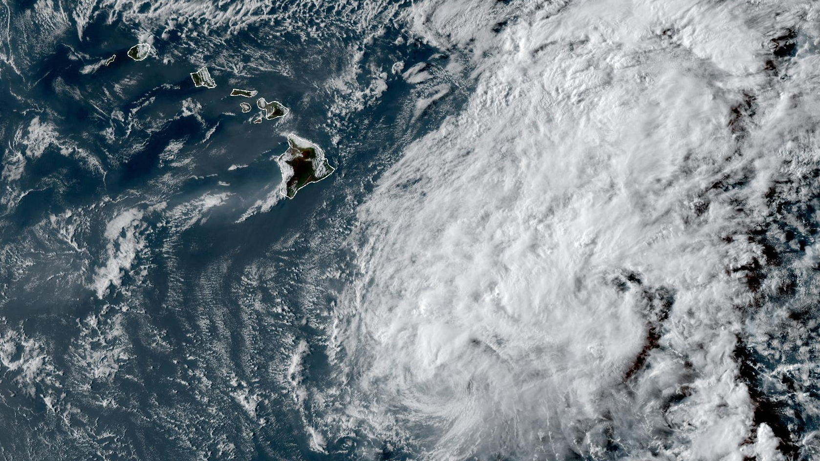

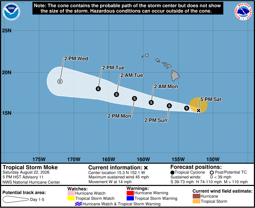
(BIVN) – Tropical Storm Moke was 360 miles south-southeast of Hilo early Saturday evening, moving west at 14 mph.
Moke weakened slightly this afternoon. Maximum sustained winds have decreased to near 45 mph with higher gusts. Tropical-storm-force winds still extend outward up to 115 miles from the center.
Moke is not expected to get any stronger as it passes south of Hawaiʻi island on Sunday.
The Central Pacific Hurricane Center is still expecting Moke to produce heavy rains over Hawaiʻi island, with totals as high as 15 inches possible. A Flood Watch is in effect for Hawaiʻi island. Hawaiʻi is likely to miss the strongest winds associated with Moke, yet strong gusty winds are still expected, particularly in areas within and downslope of higher terrain.
The County of Hawaiʻi has already announced several shelters will be open this evening, mostly in the southern half of the Big Island.
The Hawaiʻi National Guard says Task Force Hawaiʻi has 76 personnel supporting Hawaiʻi County, with five High-Wheeled Vehicle Teams (HWVT) and three aviation crews ready. During Hurricane Lala, HWVTs assisted 16 civilians and rescued two EMS personnel.
Parks on Hawaiʻi island that closed due to Hurricane Lala will remain closed through the weekend, state officials say. Kekaha Kai, Wailuku River, ʻAkaka Falls and MacKenzie state parks remain open but are prepared to close Sunday. Keanakolu and Ainapo cabins and the Puna Trail are closed. Small harbor restrooms on Hawaiʻi Island are closed, but the harbors remain open. Refunds for canceled camping and lodging permits will be credited to permit holders who miss camping nights because of storm closures, state officials say.
At Hilo International and Ellison Onizuka Kona International airports, “crews have reinspected drainage, trimmed trees, secured equipment and aircraft and prepared emergency generators” in preparation for Tropical Storm Moke.
From a Central Pacific Hurricane Center discussion posted at 5 p.m. HST:
Moke has weakened slightly during the past several hours. The persistent deep convection that had been located over and north of the circulation overnight and through the morning hours has largely collapsed, with cloud tops warming noticeably. This deterioration appears to be due, at least in part, to persistent southwesterly vertical wind shear and dry mid-level air. Peak 700-mb flight-level winds from the reconnaissance aircraft have been around 43 kt, while a UAS measured peak winds of about 38 kt while sampling near the surface in the northeast quadrant. These data, along with the deteriorating satellite presentation, support lowering the initial intensity to 40 kt for this advisory.
Moke continues to move west-northwestward, with an initial motion of 280/12 kt. A general west-northwestward motion is expected to continue during the next several days as a low- to mid-level ridge strengthens to the north of the cyclone. This track should bring the center of Moke a couple of hundred miles south of the Big Island on Sunday and then well south of the smaller main Hawaiian Islands thereafter. The track guidance remains in good agreement, and the NHC forecast is very similar to the previous forecast. Despite the center of Moke remaining south of the Hawaiian Islands, the cyclone is expected to pass close enough to produce a period of gusty winds and heavy rainfall across portions of the islands during the next couple of days.
Moke appears to be near its peak intensity, if it has not already reached it. Although vertical wind shear is forecast to decrease somewhat during the next day, an increasingly dry and stable surrounding environment should limit additional strengthening and likely cause Moke to begin weakening on Sunday. Thereafter, increasing vertical wind shear and continued entrainment of dry air should result in a gradual weakening trend through early next week. By around 96 h, both the GFS and ECMWF depict Moke becoming largely devoid of deep convection, and the cyclone could degenerate into a remnant low by Wednesday, then dissipate by day 5. The latest NHC intensity forecast is similar to the previous advisory and lies near the middle to upper end of the guidance envelope.
Key Messages:
1. Heavy rainfall associated with Tropical Storm Moke will begin to impact the Big Island of Hawaii late tonight, with rain spreading westward across the remainder of the Hawaiian Islands Sunday into Monday. This rainfall may produce life-threatening flooding and mudslides for the windward and southeast Big Island, especially in steep terrain and over areas that were affected recently by Lala.
2. Although the strongest winds associated with Moke are expected to pass south of the Hawaiian Islands, strong gusty winds are likely, particularly in areas within and downslope of higher terrain.
