
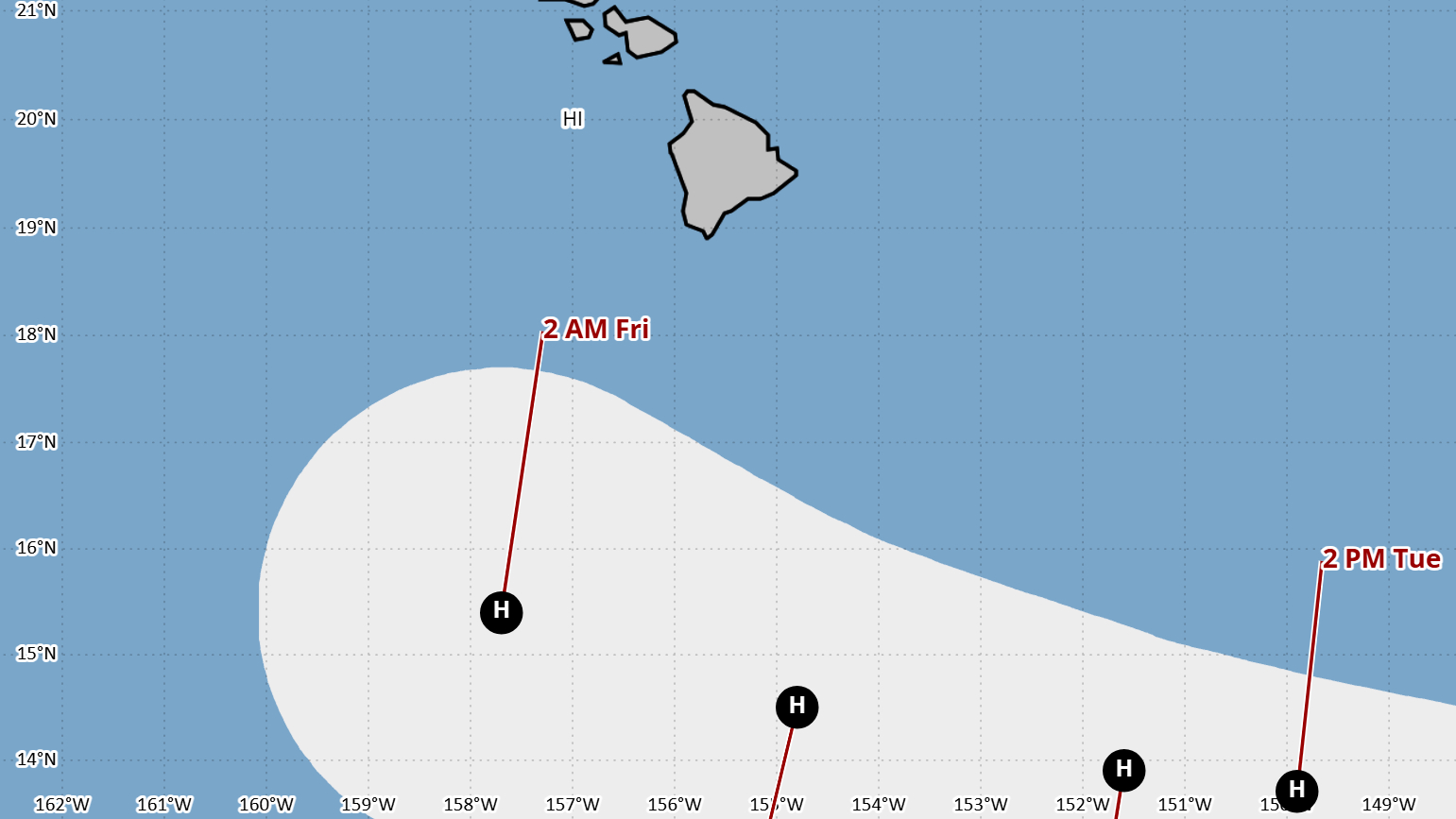

(BIVN) – Tropical Storm Lowell, located 985 miles east-southeast of Hilo as of Sunday at 11 a.m., is moving westward at 13 mph. The storm does not pose an immediate threat to Hawaiʻi, emergency officials say, but there “remains significant cross-track spread in the guidance”, which means forecasters are not certain if the storm will threaten Hawaiʻi at the end of the week.
For now, the National Hurricane Center has Lowell gradually strengthening, perhaps reaching hurricane strength by Monday night or Tuesday, and tracking to the south of Hawaiʻi island by the weekend.
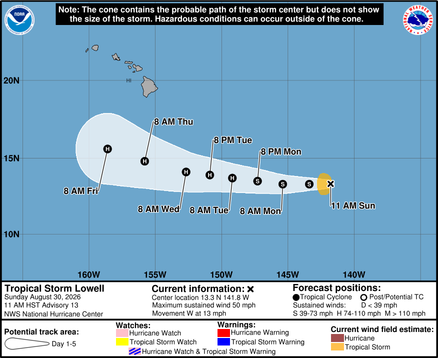
“Currently Lowell is not posing an immediate threat to the state, and will be monitored closely, and you will be kept informed of any developments,” the Hawaiʻi County Civil Defense stated in a Sunday morning message, its second alert focused on the distant storm.
“Although it is too early to forecast with confidence what if any effects Lowell will have on the state, it is always better to take the time to prepare for possible bad weather,” the emergency agency said. “As we continue through what has been forecast to be a more active hurricane season, residents and businesses are encouraged to review and develop preparedness plans.”
Much farther away from Hawaiʻi is Tropical Storm Karina, gaining strength in the Eastern Pacific. Karina is expected to develop into a major hurricane in the next few days.
At 9 a.m., the National Weather Service in Honolulu wrote:
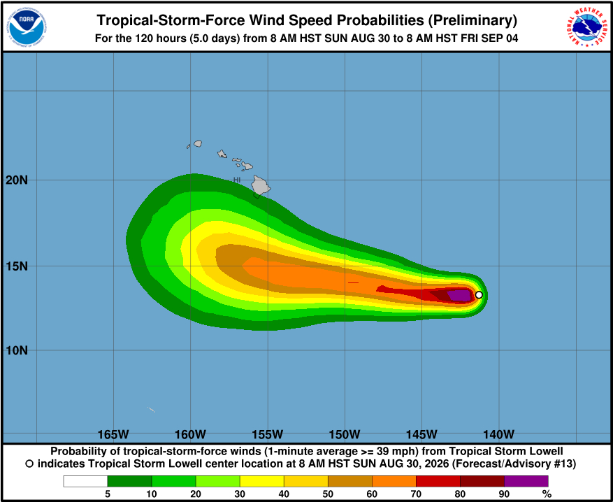
The tropics remain active with attention turning toward the Friday Sept 4th (Day 5) to Wednesday Sep 9th (Day 10) period. During this time, uncertainty runs considerably higher than normal owing to weak steering flow followed by potential emergence of a closed upper low NW of the islands that will alter steering flow and introduce a component of shearing as well. TC Lowell and TC Karina both carry potential to come precariously close to the islands during this time window. Guidance regarding both systems is plagued with the same uncertainty for the same reasons, so potential outcomes unfortunately remain wide open despite the decreasing lead time. It is worth noting that machine learning guidance remains suppressed fairly far south with Lowell and the 12z ECMWF has trended strongly in this direction. Consult NHC for the official track and intensity forecast.
From the Central Pacific Hurricane Center at 11 a.m. HST:
Lowell’s outflow to the east is starting to improve, a sign that the persistent easterly shear might be decreasing. However, this has not yet resulted in a noticeable increase in the convective organization, as the center is still located just under the eastern side of a triangular-shaped convective mass. A just-received ASCAT-C overpass shows wind vectors of 42 kt in the northwest quadrant. Based on this and the various satellite intensity estimates, the initial intensity remains 45 kt.
The initial motion is now 270/11 kt. As before, a low- to mid-level ridge north of the cyclone should remain the primary steering influence during the next couple of days, resulting in a continued generally westward motion. After that, there remains significant cross-track spread in the guidance. Some of this may be due to the possible influence of Hurricane Karina on Lowell’s steering. The two cyclones are likely to stay far enough apart that direct interaction is unlikely. However, the Canadian model forecast still suggests the possibility of Karina affecting Lowell’s motion. Another cause for the spread may be the models’ differences in the forecast of a mid-to upper-level trough northwest of the Hawaiian Islands. The GFS forecasts the trough develop farther south and create a weakness in the subtropical ridge with Lowell moving farther north, while the ECMWF keeps the trough farther to the north with less weakening of the ridge and Lowell staying farther south. Currently, it is difficult to tell which of these scenarios will become reality. The new forecast track lies near the HFIP Corrected Consensus model and is similar to the previous track.
The intensity guidance is unchanged since the last advisory, and indeed it hasn’t changed much for the past two days. Lowell should start intensifying in the next 12-24 h, with a faster rate of strengthening between 24-72 h as conditions become more favorable. The guidance suggests the intensity should level off around 96-120 h, and the forecast follows this. The new intensity forecast is an update of the previous forecast.
Civil Defense advised listeners to continue to monitor local radio broadcasts for official advisories, “and if you have any questions or require assistance, please contact the Hawaii County Civil Defense Agency at (808)935-0031 or visit the Civil Defense website.”
