
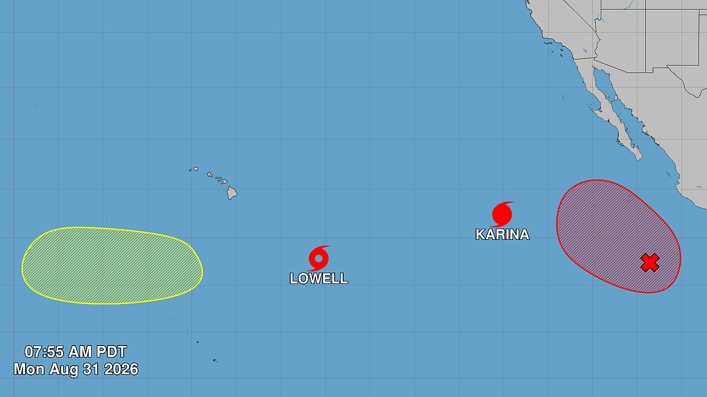

(BIVN) – Emergency officials are tracking two tropical cyclones in the Pacific that could influence Hawaiʻi weather in the coming days, or even impact the state.
Tropical Storm Lowell was located 785 miles southeast of Hilo as of 5 a.m. HST. Lowell is expected to rapidly intensify into a major hurricane as it passes south of Hawaiʻi island Wednesday evening into Thursday.
Hurricane Karina was located farther away in the Eastern Pacific, about 1,055 miles west-southwest of Baja, California as of 5 a.m. HST. With maximum sustained winds near 130 mph, Karina is a category 4 hurricane on the Saffir-Simpson Hurricane Wind Scale. Karina could be within the vicinity of the Hawaiian islands late this weekend.
Swells generated by Lowell are likely to affect portions of the Hawaiian Islands beginning around mid-week, forecasters say.
The National Weather Service had this to report on the possibility of fire weather as the storms approach the region:
Breezy trades continue through midweek and then strengthens Thursday through Friday as TC Lowell passes south of the islands. Strong gusty winds with wind gusts over 50 mph will be possible across select areas Thursday into Friday. While fuel conditions do not remain critical at this time due to the abundant rainfall we received over the past several weeks, moderate fire danger will be possible for areas mainly due to the windy conditions. Dewpoints increasing into the upper 60s and low 70s during this time should keep minimum humidities in the 50s for the most part. A few leeward areas could still see humidities down into the mid 40s especially on Thursday as a pocket of dry air moves in. The exact track of TC Lowell remains uncertain and thus potential for meaningful rainfall remains uncertain at this time. The inversion will hover between 5500 ft and 6500 ft the next couple of days.
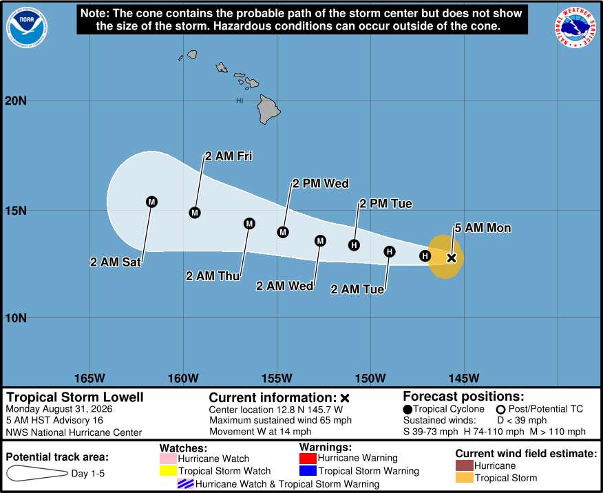
Here is the Central Pacific Hurricane Center discussion on Tropical Storm Lowell posted at 5 a.m. HST:
Lowell consists of a large central dense overcast with very cold cloud tops. A 31/1047 UTC AMSR2 pass indicates the low-level center is rapidly becoming better organized underneath the convective canopy. The latest subjective Dvorak estimates from PHFO and JTWC range from 45-55 kt, and objective estimates are a bit lower than the subjective estimates. The initial intensity is raised to 55 kt based on the improved structure noted on the AMSR2 pass.
The initial motion is just south of due west, or 260 degrees at 12 kt. A mid-level ridge north of Lowell will be the primary steering mechanism for the next few days. Lowell should move generally westward to west-northwestward during that time. Thereafter, model spread increases as Lowell slows. A west-northwestward motion is forecast after day 4 as Lowell feels some pull from a mid- to upper-level trough located well to its north. The HCCA and Google DeepMind ensemble (GDMI) are the fastest and farthest south models. The latest NHC forecast track is slightly to the left of the previous track, but not quite as far south as the GDMI.
The moderate easterly shear that has been affecting Lowell appears to be diminishing. Lowell seems poised to take advantage of warm waters to rapidly intensify, as shown by the HAFS-A and HAF-B models, which forecast Lowell becoming a major hurricane within the next 36 h. SHIPS is forecasting weak vertical wind shear magnitudes over the next 5 days. Given that the cyclone has developed a closed ring on 37 GHz microwave imagery, it is probably just a matter of time before we see Lowell strengthen significantly. The new NHC intensity forecast explicitly forecasts rapid intensification over the next 36 h, and then holds Lowell at category 3 strength through the day 5 period, since SSTs are forecast to still be between 28-29C and the shear is still forecast to be light at day 5. The new intensity forecast is between the middle and higher end of the intensity guidance envelope. This forecast is slightly above the intensity consensus, but not nearly as strong as the HCCA.
Key Messages:
1. Lowell is forecast to move generally westward and could be in the vicinity of the Hawaiian Islands late this week. Interests in Hawaii should monitor the progress of this storm.
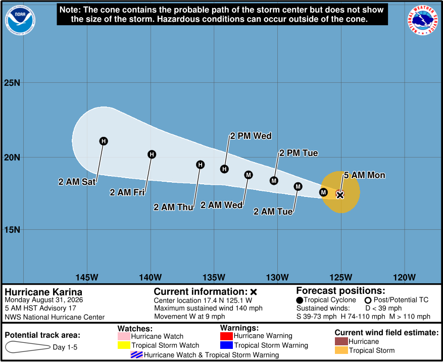
Here is the National Hurricane Center discussion on Major Hurricane Karina posted at 5 a.m. HST:
Conventional satellite imagery shows that the inner core structure of Karina has become a little less defined. The cloud tops in the northwestern portion of the eyewall have warmed to around -60 C, and the latest TAFB Dvorak satellite intensity estimate is T5.5/102 kt. The CMISS satellite intensity objective techniques range from 115 to 129 kt. Based on these data, the initial intensity remains at 120 kt.
Karina continues to move generally westward, estimated at 275 degrees at 7 kt. A narrow but extensive mid-level ridge is parked to the north of the hurricane, and this feature will likely remain the dominant steering impact on Karina over the next several days. Toward the end of the forecast period, the original ridge becomes eroded by a mid-latitude trough digging into the western US coast, but a more meridionally oriented ridge takes its place to the northwest of Karina, which should act to gradually slow its forward motion. The current NHC forecast track has been adjusted slightly to the south of the previous track based on the guidance from the HFIP Corrected Consensus Approach (HCCA) and Google DeepMind (GDMI) guidance.
While environmental conditions should remain favorable in the short term, the hurricane could experience some intensity fluctuations dueto inner-core changes. Karina may develop annular characteristicsthat could help reduce the rate of weakening the cyclone is forecastto undergo. The current SHIPS statistical intensity models indicatethat relative humidity beyond 72 h will drop below 40%, Consequently, abundant dry, stable air will impact the hurricane. Once Karina moves over cooler ocean waters past 96 h, and more dry air is pulled into the hurricane’s inner core, the rate of weakening could increase at a faster rate indicated in the official forecast which is close to the HCCA corrected consensus.
Karina’s wind radii have been adjusted based on 0553 UTC METOP-B/C ASCAT overpasses, and 0757 UTC OSCAT data.
