
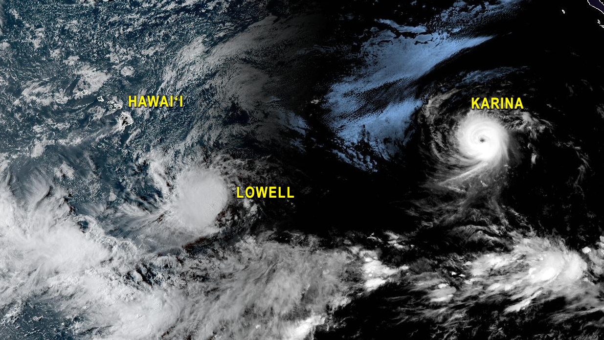

(BIVN) – Two tropical cyclones in the Pacific continue to move westward, and could arrive in the vicinity of the Hawaiian islands later this week.
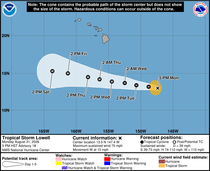
As of 5 p.m. on Monday, Tropical Storm Lowell was located 690 miles southeast of Hilo. Lowell is expected to rapidly intensify into a major hurricane as it passes south of Hawaiʻi island Wednesday evening into Thursday.
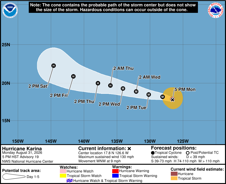
Hurricane Karina is about 1,135 miles west-southwest of Baja, California as of 5 p.m. HST. Karina is a category 4 hurricane, with sustained winds near 130 mph. Karina is expected to undergo a gradual weakening trend starting on Tuesday.
From the National Weather Service in Honolulu on Monday afternoon:
Latest forecast from the National Hurricane Center (NHC) has Lowell passing a little over 300 miles south of the Big Island Wednesday night into Thursday as a cat 3 Major Hurricane. While probabilities for tropical storm force winds remain low over the state, the tightening of the pressure gradient over the islands will likely produce very windy and gusty trade wind weather as early as Wednesday afternoon through Friday. Winds could reach advisory thresholds with wind gusts over 50 mph possible during this time. As far as rainfall, the bulk of the moisture will likely pass south of the state. Some of the outer rainbands, especially on the tail end of Lowell and the beginning of Karina could bring in some enhanced trade wind showers around Friday or Saturday.
The forecast spread drastically increases over labor day weekend into early next week as an upper level trough/low develops north of the state. Latest 12Z run of the google DeepMind (GDM) model continues to shows Lowell taking sharp northward turn over the weekend. While confidence has increased on Lowell passing south of the state during the week, the forecast still remains very uncertain over Labor day weekend into early next with several ensemble members of the GDM showing a sharp northward turn. Also during this time, we could see Karina within the vicinity of the islands late this weekend.
From the Central Pacific Hurricane Center discussion on Lowell posted at 5 p.m. HST:
Lowell appears to be showing signs of becoming better organized this afternoon. A renewed burst of deep convection has developed and is expanding over the low-level circulation center, coincident with a gradual decrease in the easterly vertical wind shear that has been affecting the cyclone during the past couple of days. Subjective Dvorak intensity estimates from JTWC and HFO range from 45 to 65 kt, while objective estimates are generally between 45 and 55 kt. Given the recent increase in convective organization and the decrease in shear, the initial intensity is increased to 60 kt.
The initial motion is westward, or about 280/9 kt. A low- to mid-level subtropical ridge north of Lowell should remain the primary steering influence during the next several days, resulting in a generally westward to west-northwestward motion. The track guidance has come into better agreement and generally shows Lowell continuing west-northwestward through much of the forecast period. By days 4 and 5, the cyclone is forecast to gradually slow and gain some latitude as a mid- to upper-level trough well northwest of the Hawaiian Islands weakens the subtropical ridge. The latest NHC track forecast is essentially an update of the previous advisory and remains between the TVCN simple consensus, the multi-model consensus (HCCA), and Google DeepMind ensemble mean.
Environmental conditions appear increasingly favorable for significant strengthening during the next couple of days. Although some easterly vertical wind shear persists, the shear is forecast to decrease further while Lowell moves over warm waters. The recent increase in convection near the center could be an indication that the cyclone is beginning to respond to these improving conditions. The intensity guidance continues to show significant strengthening, with several of the models forecasting Lowell to become a major hurricane within the next couple of days. The latest NHC intensity forecast calls for Lowell to become a hurricane with the next 12 h and a major hurricane by Wednesday. Little change in intensity is forecast thereafter as Lowell remains within a generally favorable environment through day 5.
Key Messages:
1. Lowell is forecast to move generally westward to west-northwestward and could be in the vicinity of the Hawaiian Islands late this week or this weekend. Interests in Hawaii should monitor the progress of this storm.
From the National Hurricane Center discussion on Karina posted at 5 p.m. HST:
Latest visible and infrared satellite imagery show little change in Karina’s structure over the last several hours. The 00z subjective Dvorak intensity estimate from TAFB showed an increase to T5.5/102 kt, while objective UW-CIMSS estimates range from 110 to 115 kt. Given the steady trend of Karina’s appearance on satellite, the initial intensity estimate was held at 115 kt.
Karina’s initial motion is estimated to be 285/8 kt, the same as the previous advisory. The storm is expected to continue a west-northwestward motion through the forecast period, guided by mid-level ridging centered to the northwest over the north central Pacific. Other than a slight shift northward, little was changed in the track forecast, which reflects a blend of the previous advisory, HCCA, and GDMI.
The intensity forecast is similar to the previous advisory, which remains slightly higher than the model consensus. SHIPS guidance suggests that Karina will remain in a favorable environment of low vertical wind shear, and over warm SSTs for the next couple of days. Beyond Day 3, the system will begin to encounter cooler SSTs and a drier mid-level environment. Thus, the latest forecast continues to reflects a more steady weakening trend at that time, near the intensity consensus aids.
