
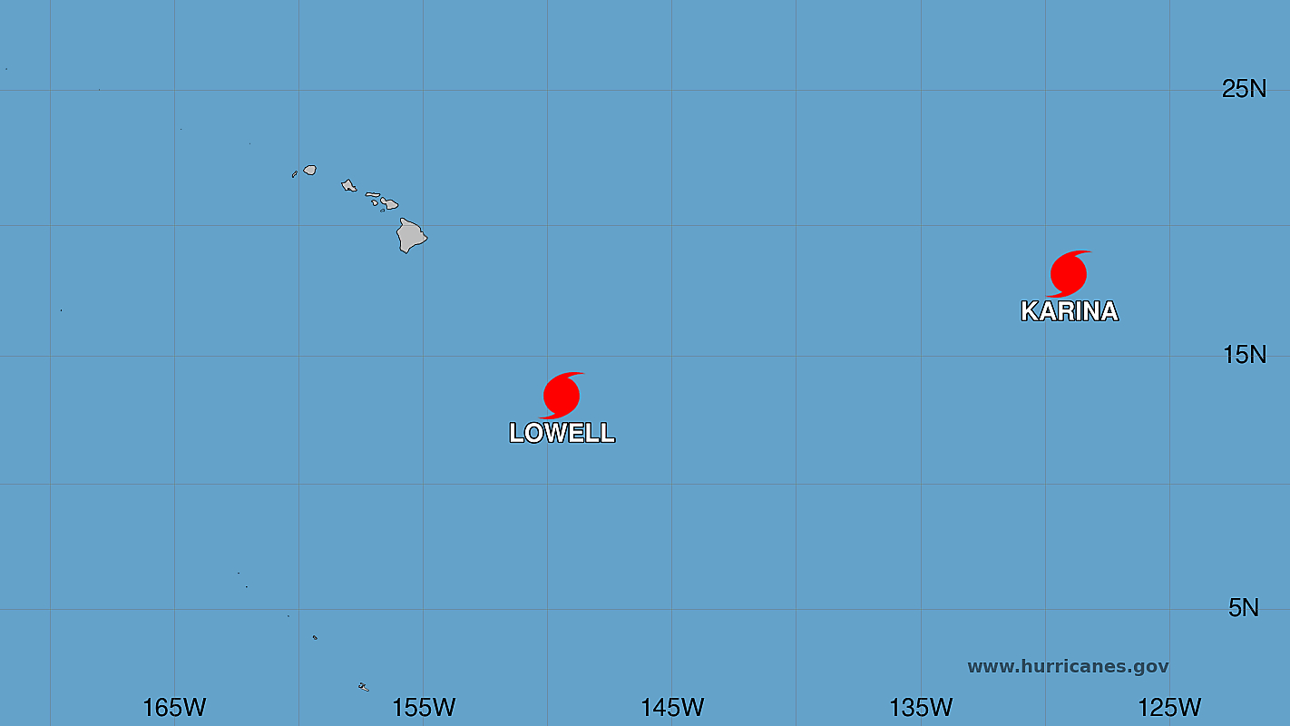

(BIVN) – Lowell has strengthened into a hurricane overnight, and was located 575 miles southeast of Hilo as of 5 a.m. on Tuesday morning.
Farther to the east, Karina remains a category 4 major hurricane, as it moves west at 12 mph.
“The latest track and cone for Lowell has the system passing south of the islands Wednesday night through Friday,” the National Weather Service wrote Tuesday morning. “Outer rainbands and moisture from Lowell could begin to spread across the islands today, increasing chances of passing trade wind showers, however the bulk of moisture will likely pass south of the state.”
“Additionally dewpoint temperatures are expected to exceed 70 degrees, which will make the atmosphere muggier than normal,” the Honolulu-based forecasters noted. “Trade winds will stay breezy due to a strong surface high remaining far north of the area.”
Hurricane Lowell is expected to rapidly strengthen into a major hurricane as it passes some 300 miles to the south of Hawaiʻi island Wednesday night into Thursday. “While probabilities for tropical storm force winds remain low over the state, the tightening of the pressure gradient over the islands will likely produce very windy and gusty trade winds as early as Wednesday afternoon through Friday. Winds could reach advisory thresholds with wind gusts over 50 mph possible during this time,” the National Weather Service noted.
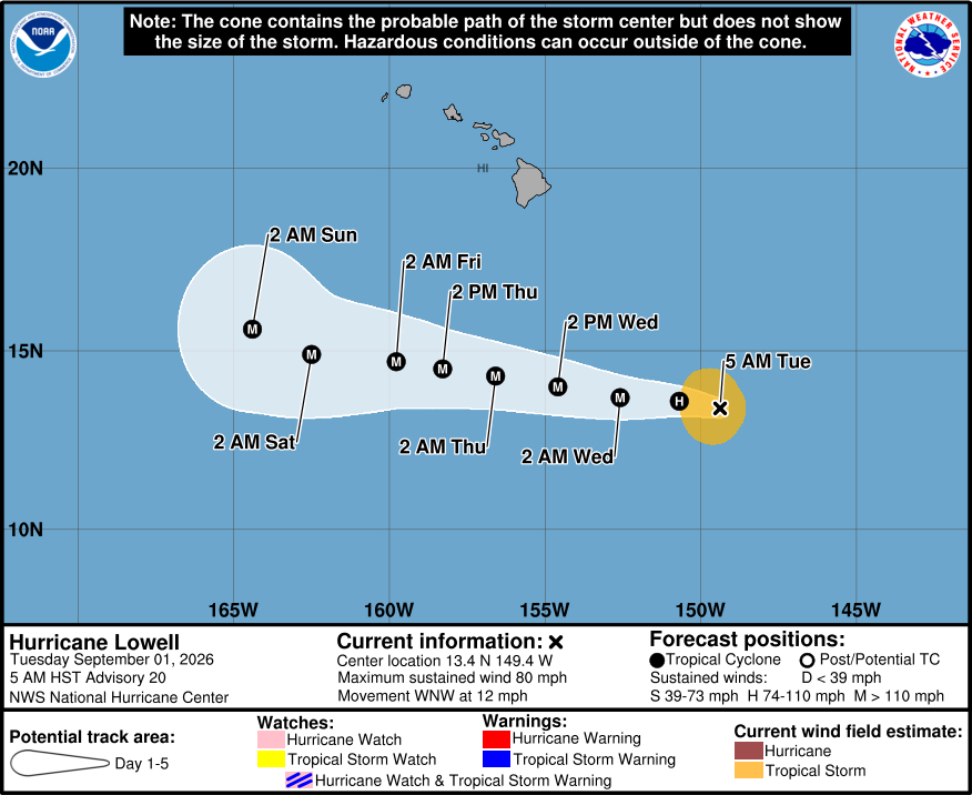
From the Central Pacific Hurricane Center discussion on Hurricane Lowell, posted at 5 a.m. HST:
The satellite presentation of Lowell has improved significantly over the past 12 to 24 hours. The cyclone consists of a large central area of very cold cloud tops with an impressive curved band extending out towards the southwest quadrant. The latest subjective Dvorak estimates from JTWC and PHFO range from 55-65 kt, and the latest objective intensity estimates range from 60 to 70 kt. Based on improving structure observed on satellite imagery over the past few hours, the initial intensity is increased to 70 kt.
The initial motion is west-northwestward, or about 285/10 kt. A mid-level subtropical ridge north of Lowell should remain the primary steering influence during the next 4 days or so, resulting in a generally westward to west-northwestward motion. The track guidance is in relatively good agreement during this time period, and generally shows Lowell continuing west-northwestward through day 4. In about 4 days, the cyclone should slow down, and may gain some latitude as a mid- to upper-level trough well north of the Hawaiian Islands weakens the subtropical ridge, possibly causing a turn toward the northwest by day 5. The latest NHC track forecast is similar to the previous one, and lies close to the Google DeepMind Ensemble Mean (GDMI) for the first 2-3 days, and is north of the GDMI and HCCA for the 3 to 5 day portion of the forecast.
Environmental conditions are ripe for Lowell to intensify rapidly over the next day or two. Now that the core is well-formed, Lowell should be able to take advantage of the weak vertical wind shear and warm sea-surface temperatures. The HAFS and HWRF models show Lowell becoming a major hurricane within the next 24 to 36 hours, and the NHC intensity forecast follows suit. The SHIPS DTOPS has about a 75 percent chance of 45 kt strengthening over the next 36 hours, and the NHC forecast shows 40 kt of strengthening during that time. The new NHC intensity forecast shows a faster rate of strengthening during the first 36 hours of the forecast, and the peak intensity has been increased slightly to 110 kt. The new NHC intensity forecast lies between the middle and upper end of the intensity guidance suite, and is in between the intensity consensus (IVCN) and the HCCA. Ocean waters should remain warm and vertical wind shear is forecast to remain low through day 5, so the NHC forecast holds Lowell at major hurricane strength through day 5.
Key Messages:
1. Interests in the Hawaiian Islands should continue to closely monitor the progress of Hurricane Lowell.
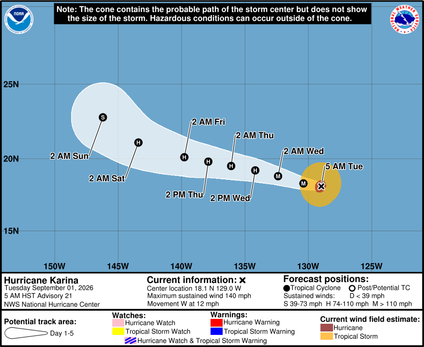
From the National Hurricane Center discussion on Hurricane Karina, posted at 5 a.m. HST:
Karina remains a powerful category 4 hurricane, although there are some signs that the cyclone might be near its peak intensity. Over the past few hours, the eye has become cloud-filled and the convective pattern is not quite as symmetric. A blend of the latest satellite intensity estimates supports maintaining the initial intensity at 120 kt. Despite being very strong, the overall cloud pattern and wind field are relatively compact.
The major hurricane is moving westward at about 10 kt. A general slow westward to west-northwestward motion is expected during the next 3 to 4 days as a narrow mid-level ridge remains situated to the north of the hurricane. Over the weekend, a turn to the northwest seems likely as the ridge shifts eastward and as the cyclone approaches a mid- to upper-level low north of Hawaii. Little change was made to the previous track forecast, except for a nudge to the north toward the end of the period. This track forecast is based on a blend of the HCCA, GDMI, and TVCN models. It should be noted that there is a fair amount of spread from days 3 to 5, and confidence in that part of the track forecast is lower than average.
Karina is forecast to gradually lose strength over the next several days. Although the wind shear is expected to remain low for the next few days, progressively cooler SSTs and decreasing relative humidity values should cause steady weakening. However, the hurricane could become annular, which might cause it to weaken at a slower pace than average. The models are unanimous in showing weakening, but vary on the rate. The NHC intensity forecast is similar to the previous one, and lies a little above the model consensus.
