
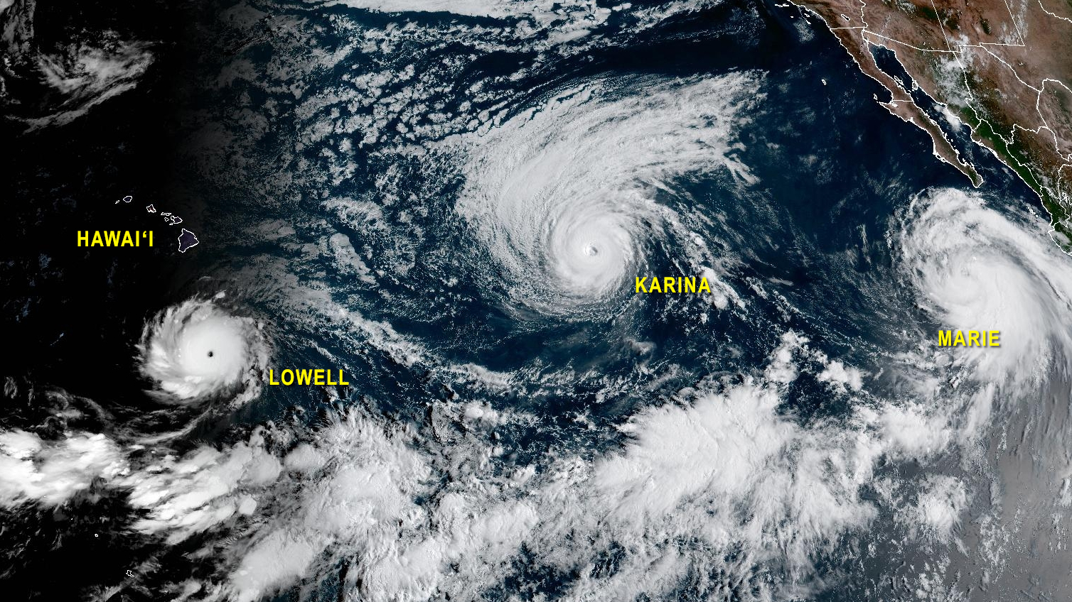

(BIVN) – Two major hurricanes will be in the vicinity of Hawaiʻi in the coming days.
Major Hurricane Lowell is tracking well to the south of Hawaiʻi island, and is expected to continue on a westward path as a category 5 hurricane for the next several days. However, Lowell is expected to take a sharp turn to the north at some point, potentially brining it close to the islands, sometime early next week. The timing of the projected turn to the north is uncertain.
Major Hurricane Karina is also making an approach to the Central Pacific, but the storm is forecast to weaken and veer off to the north of the Hawaiian islands.
As of 5 a.m. on Wednesday morning, Hurricane Lowell was 455 miles south-southeast of Hilo, moving west at 10 mph. Maximum sustained winds have increased to near 155 mph, making Lowell a category 4 hurricane on the Saffir-Simpson Hurricane Wind Scale. Further strengthening is still possible, and Lowell could become a category 5 hurricane later today or tonight.
“The latest forecast track from the National Hurricane Center (NHC) will have Lowell passing a 400 miles or so south of the islands over the next couple of days, before it turns to the north,” reported the National Weather Service in Honolulu this morning. “This northward turn of the system will be determined by the interaction of Lowell with an upper level low the models depict as sinking south towards the islands this weekend. A lot of details on the timing and exact track of the system, coupled with associated impacts, remain to be ironed out. There is uncertainty as to when that northward turn will happen, so we will be continuing to monitor the forecast and make modifications as needed.”
Hawaiʻi island is expected to miss flooding rains and damaging winds from Hurricane Lowell. Still, winds will increase do the pressure gradient between a high far north of the islands, and Hurricane Lowell to the south. Wind Advisories have been posted for parts of the Big Island.
Swells generated by Hurricane Lowell are likely to begin impacting Hawaiʻi shores today. These swells are likely to cause life-threatening surf and rip current conditions, officials say.
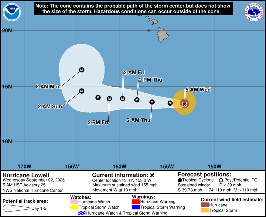
From the Central Pacific Hurricane Center discussion on Hurricane Lowell at 5 a.m. HST:
The rapid intensification of Lowell has continued early this morning. The compact hurricane has a circular, 15 n-mi-wide eye surrounded by a symmetric ring of deep convection with cloud tops as cold as -70 to -80 deg C. This impressive structure has led to an increase in the satellite intensity estimates, with JTWC and HFO recently providing T6.5/127 kt Dvorak estimates. Meanwhile, the latest AiDT and D-MINT objective estimates from CIMSS have climbed above 130 kt. Since the satellite presentation continues to improve and the eye of Lowell has warmed during the past couple of hours, the initial intensity is raised to 135 kt.
Lowell will move within conducive large-scale environmental and oceanic conditions for the next several days. With no signs yet of the commencement of an eyewall replacement cycle (ERC), some additional near-term strengthening is forecast, and Lowell could reach category 5 intensity later today or tonight. Over the next several days, the intensity of the hurricane will be modulated by internal dynamic processes like ERCs. The NHC intensity forecast is similar to the previous one and remains on the high side of the latest guidance. There is high confidence that Lowell will remain a major hurricane through the forecast period.
The hurricane is moving westward (270/9 kt). A mid-level ridge over the Central Pacific should steer Lowell westward for the next few days at a gradually slower forward speed. Only minor southward adjustments were made to the early part of the NHC forecast to account for current motion trends. An erosion of the steering ridge by a mid- to upper-level trough or cutoff low is forecast this weekend, which should cause Lowell to slow down further and turn sharply northward at days 4-5. The track guidance has shifted eastward for this portion of the forecast, and the NHC prediction was adjusted to the right of the previous track in response. There remains large model spread and above average uncertainty regarding the details of this anticipated northward turn, so interests in Hawaii should monitor the latest forecast updates.
KEY MESSAGES:
1. Interests in the Hawaiian Islands should continue to closely monitor the progress of Hurricane Lowell.
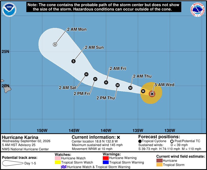
Major Hurricane Karina was about 1,455 miles east of Hilo as of 5 a.m. this morning. From the National Hurricane Center discussion on Karina at 5 a.m. HST:
Karina continues to exhibit a circular, annular structure on proxy-vis and infrared satellite imagery. The hurricane has a well-defined, warm 30 n mi eye, with deep convection wrapping around the inner core. The latest objective and subjective satellite intensity estimates from UW-CIMSS and TAFB range from 109 to 137 kt. Based on the steady satellite appearance and a range of these estimates, the intensity is held at 125 kt.
The hurricane continues to move westward at an estimated motion of 285/9 kt. The steering flow remains unchanged, with the system expected to continue moving westward to west-northwestward along the southern side of a ridge located to the north. As a mid-level low moves north of the Hawaiian islands the ridge will weaken, and the system should move northwestward. The latest NHC track is similar to the previous and lies close to the HCCA and GDMI aids.
Karina remains over marginally warm waters sea surface temperatures, tracking roughly parallel to the 26-27C isotherm. Wind shear also remains low during the next few days, before increasing beyond 72 h. Some fluctuations in intensity are possible today, before a gradual weakening trend is expected. In about 2-3 days, the system should begin to move into a drier environment and over cooler SSTs, although given the annular structure, weakening is anticipated to be more gradual than normal. The NHC intensity guidance is higher than most of the guidance, given the annular structure, and shows a gradual rate of weakening during the early part of the forecast period before a more steady rate of weakening by the end of the period. Global infrared simulated satellite imagery shows that Karina will struggle to produce organized deep convection by day 5, due to the shear and dry air, and the NHC forecast now calls for the system to become post-tropical at that time.
