
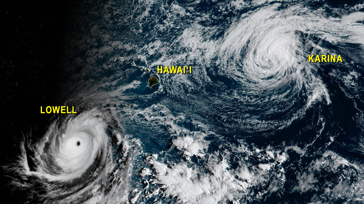

(BIVN) – Major Hurricane Lowell was located 625 miles south-southwest of Oʻahu on Saturday morning, moving slowly west at 7 mph.
With maximum sustained winds near 150 mph, Lowell is a category 4 hurricane on the Saffir-Simpson Hurricane Wind Scale. “Fluctuations in intensity are possible during the next day or so, followed by a gradual weakening trend on Sunday and Monday,” the Central Pacific Hurricane Center says.
Lowell is still expected to turn to the northwest Saturday and north-northeast Sunday. “The forecast track remains west of Kauai County, but certainly close enough to warrant our constant attention,” the National Weather Service says.
“Lowell is expected to make its closest approach to the main Hawaiian Islands Monday night as a category 2 to 3 hurricane,” the National Weather Service wrote on Saturday morning, “and any deviation eastward from its forecast track could bring more severe wind impacts especially to Kauai County.”
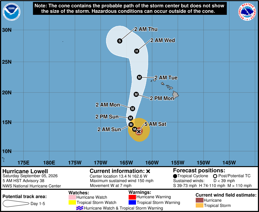
“It is currently too early for tropical watches and warnings this morning, but will be discussed and determined soon,” the Honolulu-based forecasters said. “As far as expected impacts, there remains a risk for high surf, strong winds, and heavy rainfall for all islands. A south swell has already elevated surf across south facing shores and will become extra large out of the southwest Sunday night/Monday as Lowell approaches. High surf will have the greatest coverage across the state as the swell moves from the storm, so confidence is highest with the surf and surge impacts.”
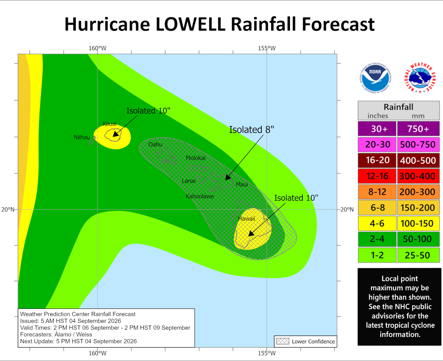
Forecasters say the heavy rainfall is likely to impact most islands at some point during Lowell’s passage.
“Hurricane Lowell is expected to produce rainfall totals of 3 to 6 inches, with maximum totals exceeding 10 inches possible, for Kauai and the Big Island,” the Central Pacific Hurricane Center reports. “This rainfall may produce locally significant flash flooding and mudslides, especially in areas of steep terrain.”
Hurricane Karina was located 795 miles east-northeast of Hilo on Saturday morning, and is forecast to dissipate late Monday or early Tuesday.
From the Central Pacific Hurricane Center discussion posted at 5 a.m. HST:
A little bit of erosion of the convection has occurred near Lowell’s eastern eyewall this morning, possibly due to mid-level shear and intrusion of dry air. Regardless, Lowell is still a powerful category 4 hurricane with maximum sustained winds estimated to be 130 kt. The latest Dvorak Current Intensity numbers from HFO and JTWC are 6.5/127 kt, and the UW-CIMSS DPRINT estimate, which has been tracking well with Lowell’s recent intensity changes, is around 130 kt. The next aircraft reconnaissance mission is scheduled for later this morning.
Lowell is moving just north of due west, or 275/6 kt, as weak mid-level ridging barely holds on to the north. A deep-layer low located about 600 n mi northeast of the Hawaiian Islands is forecast to dip southwestward over the next couple of days, further eroding the ridge, and causing Lowell to make a sharp northward to north-northeastward turn by Sunday and Monday. The guidance is coming into better focus on Lowell’s path near the Hawaiian Islands, with the bulk of the models taking the center 100-200 n mi to the west of Kauai County in about 72 hours. An important note for this forecast, however, is that the HCCA corrected consensus and the Google DeepMind ensemble mean (GDMI), which have both been performing well for this storm, lie along the eastern side of the guidance envelope. This required a slight eastward nudge to the official forecast between 60-96 hours. After passing the main Hawaiian Islands after day 3, Lowell is forecast to turn toward the west-northwest and slow down as weak ridging again builds in north of the cyclone.
The official intensity forecast shows a steady intensity for the next 24 hours while the hurricane remains in a low-shear environment and over water temperatures around 29 degrees Celsius, but fluctuations up or down will be possible. Deep-layer shear is expected to increase in about 48 hours and peak around 72 hours as Lowell approaches an upper-level trough to its northwest, which should induce a steady weakening trend. The updated NHC intensity forecast is a bit lower than the previous prediction, trending toward the latest guidance envelope, but it still shows Lowell being near or at major hurricane strength when it makes its closest approach to the western main Hawaiian Islands and passes across portions of the Papahanaumokuakea Marine National Monument. After day 3, the addition of cooler waters and drier air should cause Lowell to weaken to a tropical storm by day 5.
KEY MESSAGES:
1. Lowell is forecast to move close to the western Hawaiian Islands late Monday and Monday night. There is a risk of storm surge and wind impacts for portions of Hawaii, particularly Kauai County, early next week and watches will likely be issued later today. Residents should ensure they have their hurricane plan in place and follow advice from local officials.
2. Heavy rainfall associated with Lowell will begin to impact the Hawaiian Islands Sunday afternoon and continue through early next week. Periods of heavy rain may produce locally significant flash flooding and mudslides, especially in areas of steep terrain.
3. Swells from Lowell are likely to cause life-threatening surf and rip current conditions in portions of the Hawaiian Islands during the next several days. These swells are likely to increase early next week.
