
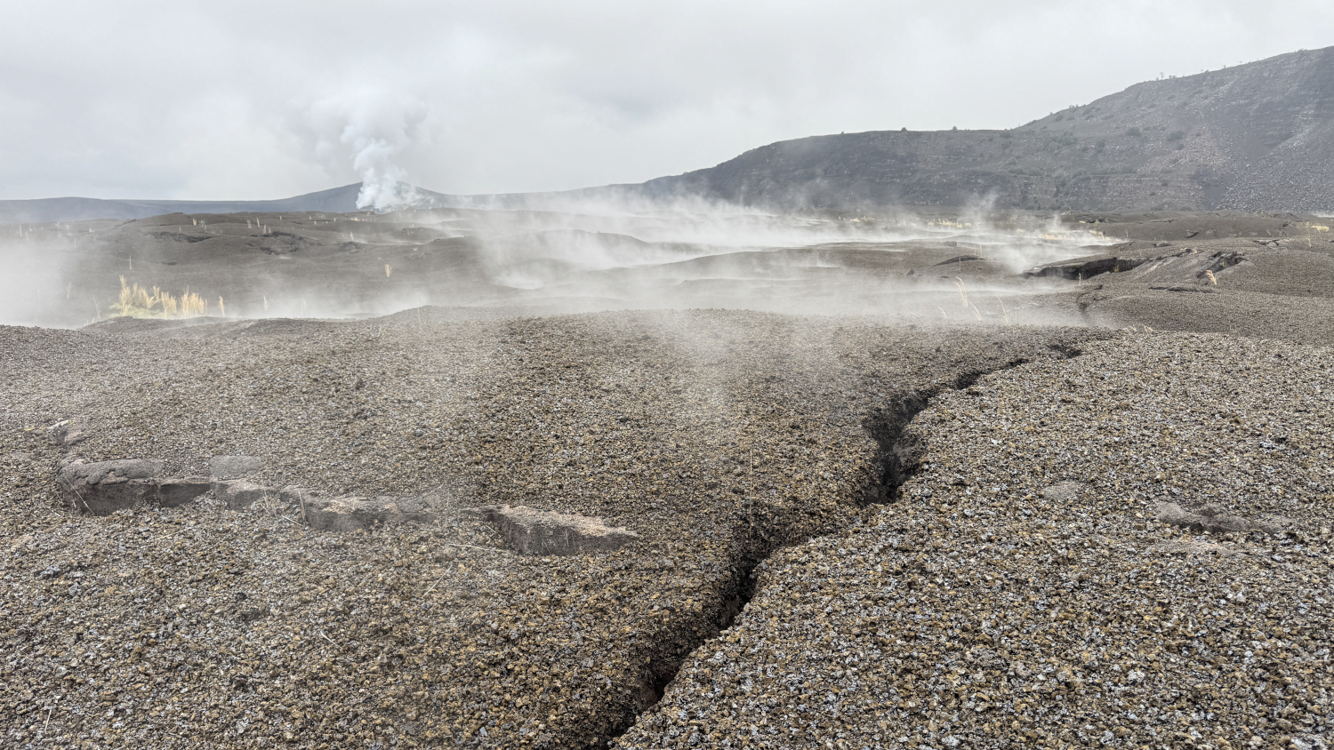

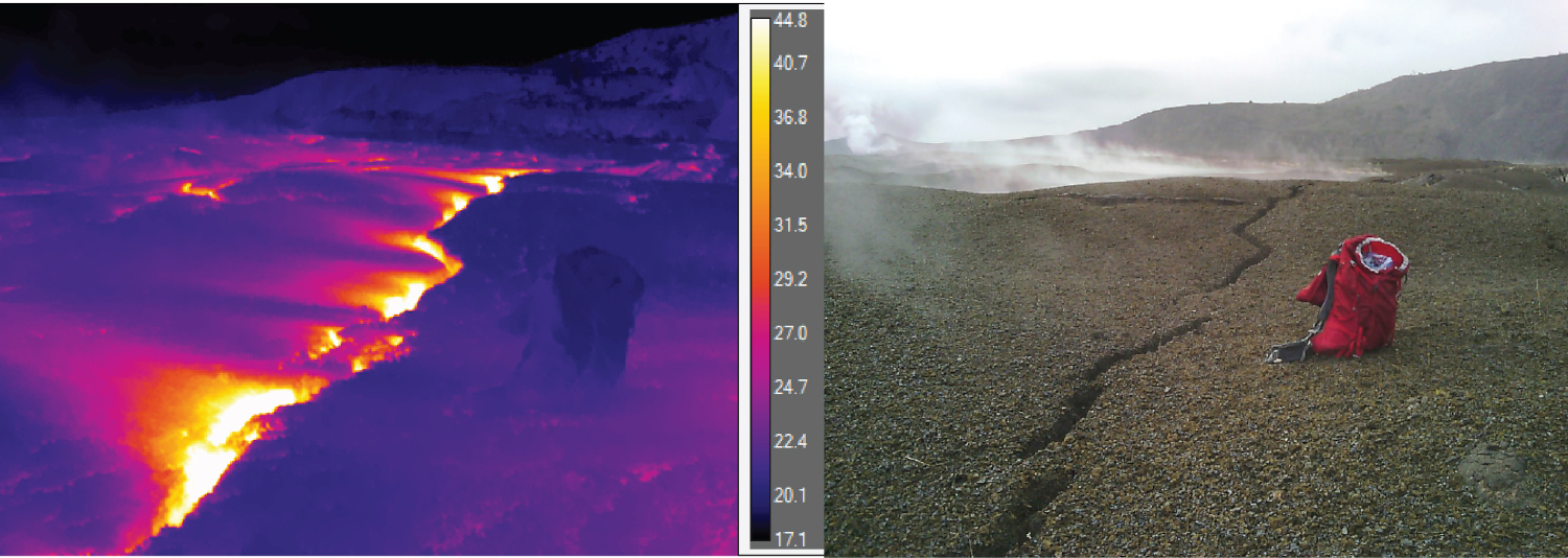
(BIVN) – Scientists have discovered some new ground cracks in the Kilauea summit area, formed as a result of the recent magma intrusion.
In a Wednesday status report, the USGS Hawaiian Volcano Observatory reported recent satellite imagery shows the intrusion of magma that was emplaced on September 30th to October 1st “followed fracture systems created in Kaluapele (Kīlauea’s summit caldera) during the 2018 collapse of Halemaʻumaʻu.”
“This intrusion was emplaced very near the surface north of Halemaʻumaʻu resulting in a narrow band of surface deformation and new, small surface fractures,” the USGS stated.
The Wednesday status report offered updated interpretations and possible outcomes on the recent activity. So far, there has been no dramatic change in the ongoing summit eruption. Glow and spatter continues to be observed at the existing vent complex in Halemaʻumaʻu.
From the USGS HVO:
Emplacement of the Dike Intrusion
An earthquake swarm began around 2 p.m. HST on the afternoon of September 30th about 1 mile (1.5 km) beneath the vent complex in Halemaʻumaʻu. About 30 located events occurred in this area and by about 8 p.m. HST, the seismicity had moved northeastward at the same depth, extending from the rim of Halemaʻumaʻu well into Kaluapele. An additional 50 events were located in this area before 4 a.m. HST on October 1. Earthquakes continued to occur at diminishing rates over the next day, with the largest event being a magnitude-3.5 at 7:55 a.m. HST on October 2, located beneath the northern edge of Halemaʻumaʻu. About 130 earthquakes were recorded in total.
The USGS Hawaiian Volcano Observatory issued a Status Report describing the intrusion of a dike, a sheet-like vertical body of magma, into the northwestern part of Kaluapele. Dikes are formed when magma intrudes sub-vertical cracks as it moves beneath the surface. The earthquakes were accompanied by a rapid increase in the rate of tilt at the Uēkahuna tiltmeter, which showed more than 40 microradians of change towards the northwest over about eighteen hours. The other summit tiltmeters saw changes of only a few microradians as reported in the Daily Update for Kīlauea on October 1. The localized nature of the tilt changes indicated they were caused by the intrusion of magma near the western rim of Kaluapele and much closer to the surface than the Halemaʻumaʻu magma chamber. The event was described in detail in the Volcano Watch published later in the day on October 1. The combination of seismicity and tiltmeter data was able to provide the timing of events and the general location, but not the shape and size of the dike.
Location and Shape of the Dike Intrusion
Recent Interferometric Synthetic Apeture Radar (InSAR) satellite images were used to construct an interferogram that more precisely determines the shape and location of the dike intrusion. The interferogram requires a satellite image acquired before and one after the event, so it can be several days to two weeks before the pair of images are both acquired. Orbital passes by the Italian Space Agency’s COSMO-SkyMed Second Generation satellites on September 24 and October 2 were used to construct an interferogram map showing the interpreted location and length of dike intrusion.
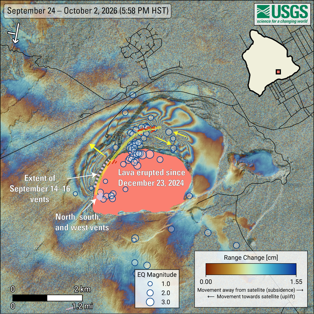
The patterns of surface deformation show that the dike extends from the established vent area in Halemaʻumaʻu and cuts across the northwestern part of Kaluapele. The deforming areas following parallel to the western rim of Halemaʻumaʻu and Kaluapele are very narrow and elongate, mapping the path of magma intruding within a thousand feet (about 300 meters) or less of the surface. The path of the dike follows fractures in the caldera floor that formed in 2018 and created a series of new, small fractures that were identified on other satellite images.
Interpretation
The rising elevation of the established north-south-west vents over the course of this eruption has increased the pressure necessary to push magma out of the vents and trigger a major fountain episode. The normal pattern of consistent rates of summit inflation prior to the onset of fountain episodes began to change to stepwise inflation prior to episode 51. Episodes 51-54 all showed similar patterns of inflation, broken by periods of no inflation that could last for several days. Since the end of fountaining episode 54 on August 25, these inconsistent inflationary patterns have continued. The opening of six vents on and below the northwest wall of Halemaʻumaʻu on September 14-16 suggests that magma is able to intrude into pre-existing weak, fractured areas along the northern and western boundaries of Halemaʻumaʻu without having to create new space (that event lacked earthquakes and significant deformation). The September 30-October 1 intrusion shows that magma is also exploiting fractures formed within Kaluapele during the 2018 collapse, and that event was accompanied by earthquakes and ground deformation as cracks either open or expand and compress adjacent rocks. The occurrence of these two small-volume intrusions below Kilauea’s summit region within the past month suggests the pressure required to erupt dense degassed magma from the established vents is also high enough to allow magma to exploit weaknesses below the surface along the pre-existing, 2018 crack systems. Magma is being injected into these weak areas as dikes that start from the subsurface dike below the established vents and move northwards into the fractured areas.
Possible Outcomes
The impact of Kīlauea summit increased pressurization and earthquakes on the next episode of lava fountaining, if any, is unknown at this time. It is not possible to forecast an exact outcome of this activity. It is clear that the patterns of forecastable eruptive behavior at Kīlauea summit are no longer being observed in volcano monitoring data. Some potential scenarios are described below based on summit conditions and past episodic eruptions of Kīlauea (1983 Puʻuʻōʻō and the 1969 Maunaulu eruptions). These past eruptions both continued after lava fountaining episodes ended, with fissures opening nearby or collapse of the vents leading to continuous eruption of lava flows. The possible scenarios presented in the Status Update of September 15 have been updated and presented below. While the current activity is no longer necessarily precursory to a fountaining episode, it is evidence of growing instability in the system that may result in significant change. For both the Puʻuʻōʻō and Maunaulu eruptions the change was from short-lived, high volume episodic fountaining to long-lived, low volume continuous eruption of lava.
Eruption returns to fountaining: It remains possible that a fountaining episode from the established north-south-west vent complex in Halemaʻumaʻu could still occur. The conditions necessary for the onset of a fountaining episode, including vertical cylindrical conduits, high magma pressure, and continued input of magma into the shallow Halemaʻumaʻu magma, still exist. However, intermittent overflows since September 6 have likely allowed the magma in the conduits to degas more magma, perhaps inhibiting the rise of the hotter, more gas-rich magma necessary to trigger a fountaining episode. A period of prolonged and larger-volume overflows may be required to allow more gas-rich magma to rise up into the conduits.
Continued intrusions within the summit region: Magma could continue to exploit weak regions along the margins of Halemaʻumaʻu and beneath Kaluapele aseismically (without earthquakes) or accompanied by earthquakes and changes in ground deformation patterns. Continued intrusive activity in the same region as the September 30-October 1 dike intrusion is the most likely, as there are multiple crack systems in the area north of Halemaʻumaʻu crater. It is also possible that increased pressure could open other fracture systems along the south and west margins of Halemaʻumaʻu but this area was not heavily fractured during the 2018 summit collapse.
Formation of new vent(s) in summit region: Magma could establish a new shallow pathway toward the surface, potentially resulting in new vents erupting lava within the summit caldera. There are two likely scenarios, one would produce earthquakes, potentially with tightly clustered locations, along with changes in the patterns of ground deformation indicative of shallow crack formation, similar to what occurred during the new vent formation during episode 30 on August 6, 2025, when a crack in the southwest wall of Halemaʻumaʻu briefly erupted. The other is passive eruption from vents such as happened on and below the northwest wall of Halemaʻumaʻu on September 14-16. Lava erupted along existing crack features without significant seismicity or changes in ground deformation. Currently the most likely place for new vents to erupt would be along the base of the northern wall of Halemaʻumaʻu crater. This area is at a lower elevation than the current vent complex and was the site of the two shallow magnitude 3.4-3.5 earthquakes associated with the dike intrusion. Eruptions on the floor of Kaluapele are less likely as they would be at a higher elevation than the established vent complex.
Intrusion into the upper parts of the Southwest Rift Zone or East Rift Zone: Magma could migrate into the upper portion of the Southwest Rift Zone or the East Rift Zone in Hawaiʻi Volcanoes National Park. In this scenario, we would expect an extended period of increased rates of earthquakes migrating from the summit towards a rift zone, along with ground deformation indicative of summit magma chamber deflation.
The eruption could stop: Changes in magma supply and stress within the volcano could result in the end of this eruption.
Scientists and officials are monitoring the situation. The USGS Volcano Alert Level for Kīlauea remains at WATCH and the Aviation Color Code is ORANGE.
