HAWAII ISLAND, Hawaii: The Hawaii Department of Land and Natural Resources has announced the re-opening of State marine waters for the Deep-7 bottomfish for 2011-2012, excluding 12 restricted areas, which includes three spots off the Big Island.
DLNR issued this media release on Wednesday:
The Department of Land and Natural Resources announces the re-opening of State marine waters on Thursday, September 1, 2011 for the 2011-2012 bottomfish fishing year.
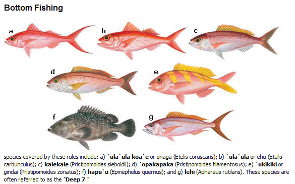
The fishing year was closed earlier this year on March 12, 2011 and remained closed through August 31, 2011. Seven bottomfish species were affected by this closure: onaga, ehu, opakapaka, kalekale, gindai, lehi, and the hapu‘upu‘u.
The federally established annual catch target (ACT) for the new fishing year is 325,000 pounds of Deep-7 bottomfish. The ACT is monitored through commercial landings. The bottomfish fishery will close when the 2011-2012 commercial landings reach the ACT limit, or on August 31, 2012 when the fishing year ends, whichever comes first.
The Department also reminds bottomfish fishers that when the new fishing year opens on September 1, 2011, the State’s twelve bottomfish restricted fishing areas or BRFAs will continue to remain closed to bottomfish fishing. Fishers are advised to consult the Department’s website for the locations of the twelve restricted fishing areas.
For all of the rules — both existing and amended — that are in force for bottomfish and bottomfishing and the locations of the 12 restricted fishing areas, please visit the Department’s website: http://hawaii.gov/dlnr/dar/fishing_bottom.html
Commercial fishermen who have questions about their catch reports may call the Division of Aquatic Resources at (808) 587-0594.
For more information about federal regulations or permits, contact the National Marine Fisheries Service (NMFS) at (808) 944-2200, or the Western Pacific Regional Fishery Management Council (WESPAC) at (808) 522-8220.
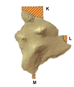
Graphic below courtesy DLNR
 The three spots on Hawaii Island are (with coordinates and offsite links to DAR maps):
BRFA K: Hawai`i (2.8 MB)
North: 20°21′ N South: 20°05’30 N
West: 155°53′ W East: 155°25′ W
Offshore distance: 0.5 nmBRFA L: Hawai`i (2.3 MB)
North: 19°44′ N South: 19°35′ N
West: 154°59’50 W East: 154°54′ W
Offshore distance: 0.15 nmBRFA M: Hawai`i (1.9 MB)
North: 18°57′ N South: 18°51′ N
West: 155°41′ W East: 155°37′ W
Offshore distance: 0.5 nm


by Big Island Video News1:17 pm
on at
STORY SUMMARY
HAWAII ISLAND, Hawaii: The Hawaii Department of Land and Natural Resources has announced the re-opening of State marine waters for the Deep-7 bottomfish for 2011-2012, excluding 12 restricted areas, which includes three spots off the Big Island. DLNR issued this media release on Wednesday: The Department of Land and Natural Resources announces the re-opening of […]