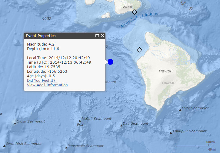
(ABOVE MAP) Screen capture of USGS map shows the location of Friday’s quake (courtesy HVO website)
NEWS BRIEF
- A magnitude-4.2 earthquake rumbled in the waters off the west coast of Hawaii Island on Friday (December 12) at 8:42 p.m. No tsunami was generated.
- The earthquake was 35 miles west-northwest of Kailua-Kona. USGS received over 100 felt reports within two hours of the earthquake, but no damage was reported.
- The earthquake caused no detectable changes on the active volcanoes on the Island of Hawaii.
PRIMARY SOURCE

The U.S. Geological Survey’s Hawaiian Volcano Observatory (HVO) recorded a magnitude-4.2 earthquake located off the west coast of the Island of Hawaiʻi on Friday, December 12, at 8:42 p.m., HST. The Pacific Tsunami Warning Center determined that no damaging tsunami was generated (http://ptwc.weather.gov/?region=2).
According to Wes Thelen, HVO’s Seismic Network Manager, the earthquake was centered about 56 km (35 mi) west-northwest of Kailua-Kona, Hawai‘i, and 114 km (71 mi) south of Kihei, Maui, at a depth of 11.6 km (7.2 mi). A map showing its location is posted on the HVO website at http://hvo.wr.usgs.gov/seismic/volcweb/earthquakes/.
The USGS “Did you feel it?” Web site (http://earthquake.usgs.gov/eqcenter/dyfi/) received more than 100 felt reports within two hours of the earthquake. Most of the felt reports were posted from the islands of Hawaiʻi and Maui, but a few were from Oʻahu, over 200 km (125 mi) from the epicenter. Only weak shaking (Intensity III) has been reported. At these shaking intensities, damage to buildings or structures is not expected.
The earthquake has caused no detectable changes on the active volcanoes on the Island of Hawaiʻi.
As of 8:00 a.m., HST, Saturday morning, December 13, no aftershocks of the magnitude-4.2 earthquake have been recorded. Friday’s earthquake was not an aftershock of the October 2006 magnitude-6.7 Kīholo Bay earthquake.
During the past 30 years, there have been 7 earthquakes, including last night’s event, in this general area with magnitudes greater than 3.0 and depths of 10–20 km (6–12 mi). Earthquakes at this depth off the west coast of the Island of Hawaiʻi are most likely caused by structural adjustments within the Earth’s crust to accommodate the heavy load of Mauna Kea, Mauna Loa, and Hualālai volcanoes.USGS Hawaiian Volcano Observatory on Dec. 13 at 8:12 a.m. HST