

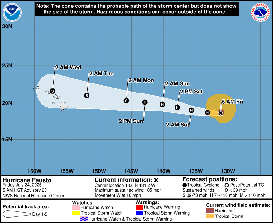
UPDATE – (7:45 a.m.) – As of Friday morning, Hurricane Fausto gained some strength with maximum sustained winds now at 105 mph.
From the National Hurricane Center discussion at 5 a.m. HST:
The models are in good agreement that Fausto is likely near its peak intensity. However, it is worth noting that the guidance has struggled to capture the trends in Fausto’s intensity over the past few days. Nonetheless, decreasing water temperatures and drier air should cause the cyclone to gradually lose strength, and an increase in westerly vertical wind shear early next week will likely aid in that weakening trend. The NHC intensity forecast lies near the middle of the guidance envelope, and shows steady weakening through the period. There is relatively high confidence that Fausto will be a tropical storm when it is in the vicinity of the Hawaiian Islands.
Key Messages:
1. Although Fausto is expected to weaken as it approaches the Hawaiian Islands during the early to middle portions of next week, there is an increasing risk of some impacts from wind and rainfall. However, it is too soon to determine the exact location or magnitude of these impacts, and interests there should continue to monitor the progress of this storm.
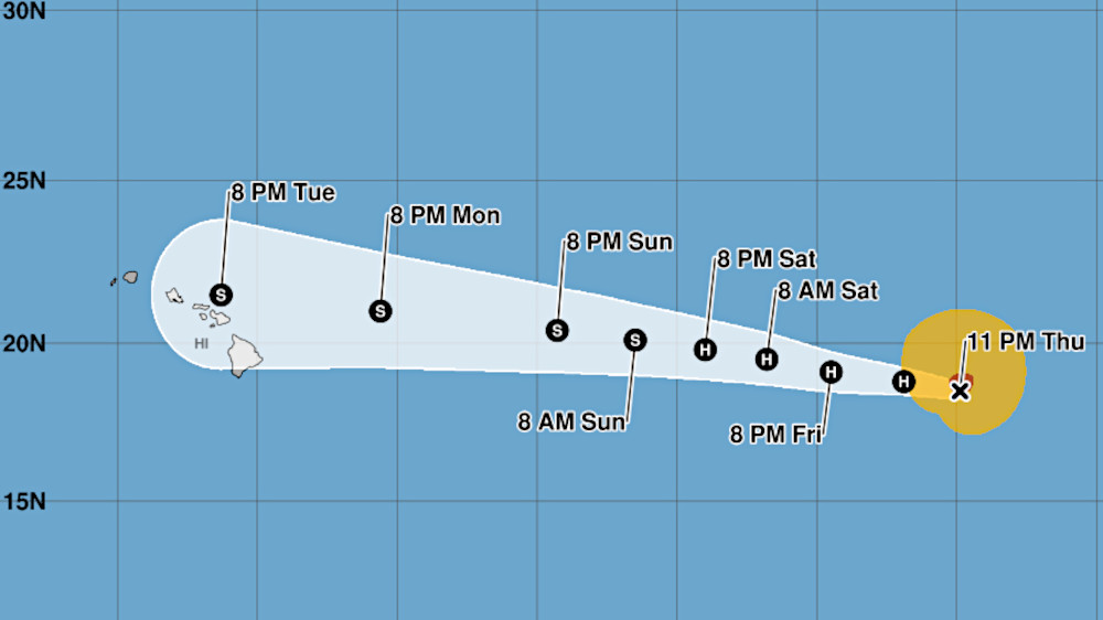
(BIVN) – Hurricane Fausto was 1,645 miles east of Hilo as of Thursday night, heading west at 15 mph.
Maximum sustained winds have increased to near 100 mph (155 km/h) with higher gusts. Little change in intensity is forecast through tonight, the National Hurricane Center reports, with steady weakening expected through the weekend.
The latest forecasted track shows Fausto approaching the Hawaiian islands as a weakening tropical storm during the early to middle part of next week.
“The risk of some impacts from wind and rainfall is increasing,” the National Hurricane Center stated. “However, it is too soon to determine the exact location or magnitude of these impacts, and interests there should continue to monitor the progress of this storm.”
From the National Hurricane Center discussion at 11 pm HST:
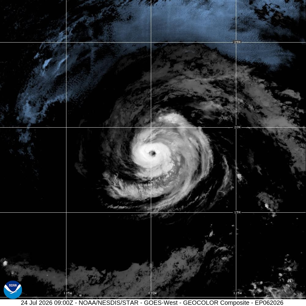
An earlier GMI microwave pass around 0104 UTC showed the western eyewall of Fausto starting to erode. Since the last advisory, however, infrared satellite imagery shows that deep convection with cold cloud tops near -75C has wrapped back around the inner core. Meanwhile, the eye continues to appear ragged from time to time. Objective satellite estimates from UW-CIMSS range from 81 to 88 kt, while the subjective TAFB Dvorak satellite intensity estimate is T4.5/77 kt. Given the latest satellite trends and a blend of these estimates, the intensity is increased to 85 kt for this advisory.
A ridge to the north continues to steer Fausto toward the west, or 280 degrees at 13 kt. This general west to west-northwestward motion is expected to persist throughout the forecast period. On this track, the system should pass just north of the Hawaiian Islands by Day 5. Little change was made to the NHC track forecast, which remains lies near the southern edge of the guidance envelope near the HCCA corrected-consensus aid and the Google DeepMind ensemble mean.
Fausto remains in a marginal environment with sea surface temperatures of 26–27C and low-to-moderate mid-level wind shear, which could allow the intensity to fluctuate over the next day or so. Surrounding dry air has so far failed to penetrate the inner core. Conditions are expected to become more hostile in 36 to 48 hours as mid-level relative humidity drops below 50 percent, followed by increasing westerly wind shear beyond Day 3. Accordingly, the updated forecast calls for gradual to steady weakening, in line with recent model trends. While several regional hurricane models, particularly those with more northern tracks, depict faster weakening and decay into a remnant low before Day 5, the official NHC forecast maintains continuity. As the track forecast lies on the southern edge of the guidance envelope, Fausto is forecast to remain a tropical cyclone throughout the 5-day period.
Key Messages:
1. Fausto is forecast to approach the Hawaiian Islands during the early to the middle portion of next week. The risk of some impacts from wind and rainfall is increasing. However, it is too soon to determine the exact location or magnitude of these impacts, and interests there should continue to monitor the progress of this storm.
