(BIVN) – Here is the Saturday morning update on the eruption of Kilauea Volcano from both the USGS Hawaiian Volcano Observatory and Hawaii County Civil Defense.
ERUPTION UPDATE
Lower East Rift Zone:
The lava flow in Leilani Estates has slowed its advance and is 150 yards from Pohoiki Road, civil defense reports. There is no immediate lava threat to Puna Geothermal Venture.
According to the USGS at 6:43 a.m. HST:
Fissure 22 continues to erupt lava that is flowing southeast to the coast and the lava ocean entry. Fountains at Fissures 6 and 13 feed lava into a channel that reaches the coast forming a second ocean entry.
Fissures 7 and 21 are feeding a perched lava pond and pāhoehoe flow that has advanced northeastward covering most of the area between Kaupili and Mohala Streets. The flow front has become an ‘A’ā flow and is advancing slowly toward Pahoa Pohoiki Road. The latest observations indicate the flow front is about 150 yards from the road. On the west side of Fissure 7 a perched pāhoehoe flow (near Makamae St) broke out around 04:00am feeding short flows to the west. Overnight, flaming and vigorous spatter was observed from a cone on Fissure 8, while Fissure 17 was the source of multiple booming gas emissions. Sensors in the LERZ indicated that the lava ocean entries remained active overnight.
Volcanic gas emissions remain very high from the fissure eruptions, scientists say.
“Take action to limit further exposure and be prepared to leave the area with little to no notice if necessary,” civil defense stated this morning. “Stay alert for warnings from Civil Defense officials.”
Summit:
According to the USGS at 6:43 a.m. HST:
There were three explosions from Overlook Crater (00:42am, 01:44am, and 05:00am) that produced ash clouds to between 10,000 and 11,000 feet above sea level. The National Weather Service Nexrad radar indicated that the clouds quickly dispersed. Several smaller explosions occurred over the course of the night. Moderate trade winds were blowing to the southwest and light ash fall likely occurred in downwind locations.
Earthquakes in the summit region continued at a moderate rate overnight. The earthquakes and ash explosions are occurring as the summit area subsides and adjusts to the withdrawal of magma.
Additional explosive events that could produce minor amounts of ashfall downwind are possible at any time. Volcanic gas emissions at the summit remain high.
To help residents, Hawaii County will be distributing free masks for ash protection:
- Distribution is today from 9 AM to 1 PM at Cooper Center, Hawaiian Ocean View Community Center, Pahala Gym Annex and Naalehu Nutrition Center.
- Each person may receive up to three masks.
- Masks do not protect against gasses and vapors. They will only provide filtering for ash.
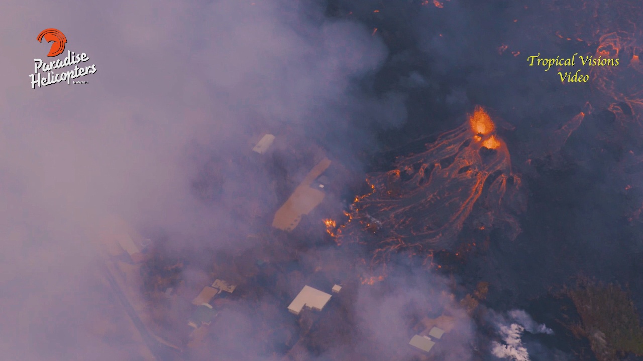
Flying over the lower East Rift Zone yesterday, videographer Mick Kalber provided these notes:
Lava from Kilauea Volcano’s current Leilani Estates Flow on the Big Island of Hawaii has now consumed 82 homes since the eruption began on May 3. Pele continues to pour her molten rock into the ocean just southwest of Pohoiki. Numerous fissures continue to spew lava, some fountaining, others oozing. More fissures have now opened up atop the May 6th Luana and Makamae flow just below… the most recent, a small outbreak at the top of the May 6th flow between Luana and Nohea. Those fissures are spreading lava in both directions… across Leilani to the north, and toward Malama to the south, and downslope… picking off houses one by one. Huge cracks have appeared half way up the subdivision, particularly on the Malama side of Pomaikai. Over the past several days, Pele has ventured uprift… the question remains… how far up will she go? Also of note are fissures 5 and 6 at the bottom of Leilani. They have gone from oozing to fountaining, destroying several structures at the old state Geothermal test site and are now creating a “perched pond,” now a raised thirty-foot tall lava lake between the fissures. Meanwhile Fissure 22, the largest of them all, is holding a steady volume, after a recent slow down. The uptick in activity near the PGV Geothermal plant has not moved lava much closer to the facility… instead, the breakouts nearby have been pouring a huge volume of lava downslope and ponding. Both a’a and pahoehoe flows continue to pour over the sea cliffs in great volume just southwest of Pohoiki. Numerous fingers of lava have stretched toward the sea over the past several days, covering many properties, and destroying many homes… leaving others and their owners wondering what’s next. Although it began in Leilani on May 3rd, and burned several homes there, she soon established her vents below the subdivision with towering fountains, spatter cones feeding gigantic lava flows. So far, no deaths have been reported. Pohoiki Road and Highway 137 have both been covered with lava, but Highway 132 is still open as of this writing. More tomorrow!