NPS Photo/J.Wei
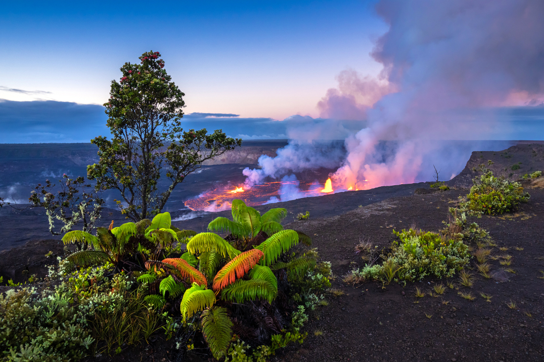
(BIVN) – The eruption of Kīlauea volcano continues at the summit caldera. Lava fountains have decreased in height since the eruption onset, but when it comes to the USGS webcam view at night, there is still plenty to see.
The view captured by the webcam has been wandering from one interesting lava formation to another. Multiple minor fountains remain active in the central and eastern portion of the crater floor. One vent is open above, on the west wall of the caldera.
Active lava covers much of the crater floor. The Hawaiian Volcano Observatory says the very earliest phases of this eruption appears have had an effusion rate that was significantly higher than the previous three Kilauea summit eruptions. An average effusion rate of approximately 150 cubic meters per second is estimated for the initial 24 hours of the event.
USGS photo
On Thursday evening, the lava lake appeared to be somewhat stagnant when viewed in real time. However when the webcam video is sped up, the pattern of lava circulation becomes evident.
As far as the rising lava lake goes, scientists say that after an initial rise of approximately 6 meters (20 feet) of lava depth was added to the crater floor, the level decreased over the past day by 2 meters (6 feet) likely due to the loss of gas. Geologists say this drop left a sort of bathtub-ring of cooled lava along the cliffs at the edge of the crater floor.
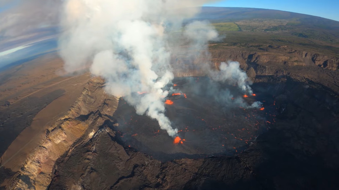
During a Wednesday helicopter overflight, the Observatory was able to capture the aerial imagery needed to put together this thermal map. This is how it looked about two hours into the eruption. The red colors on the lava lake indicate warmer temperatures.
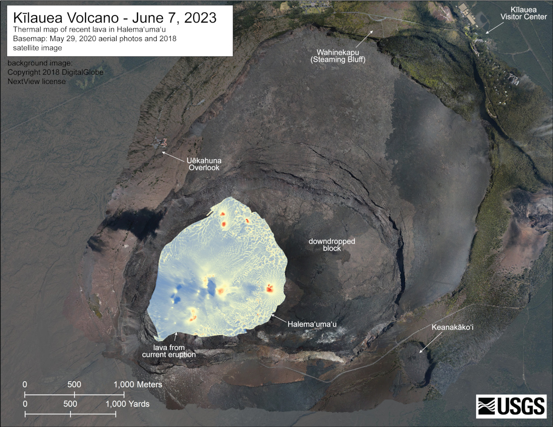
USGS: “A helicopter overflight on June 7, 2023, allowed for aerial visual and thermal imagery to be collected of Halema‘uma‘u crater at the summit of Kīlauea. The overflight happened about two hours after the start of the new eruption at the summit, and eruptive activity consisted of lava fountaining and lava lake activity. The scale of the thermal map ranges from blue to red, with blue colors indicative of cooler temperatures and red colors indicative of warmer temperatures.”
On Thursday, the Observatory lowered the Kīlauea Alert Level from WARNING to WATCH after the initial high effusion rates declined, and no infrastructure was threatened. The Aviation Color Code dropped from RED to ORANGE because there is currently no threat of significant volcanic ash emission into the atmosphere, outside of the hazardous, closed area. Still, volcanic gas emissions remain elevated. Approximately 65,000 tons per day of sulfur dioxide was measured on June 7th.
The Observatory says Kīlauea’s summit eruption is expected to remain confined to the summit crater within Hawaiʻi Volcanoes National Park, and there continues to be no indication of activity migrating elsewhere on the volcano.

by Big Island Video News
on at
STORY SUMMARY
HAWAIʻI VOLCANOES NATIONAL PARK - There continues to be no indication of activity migrating elsewhere on the volcano, and the alert level remains at WATCH.