(BIVN) – Kilauea is not erupting and the USGS Volcano Alert Level remains at ADVISORY.
In a Tuesday update, the USGS Hawaiian Volcano Observatory confirmed that earthquakes under the Hawaiʻi island volcano have returned to low levels, and ground deformation is steady. There are also no indications of any changes downrift in the lower East Rift Zone.
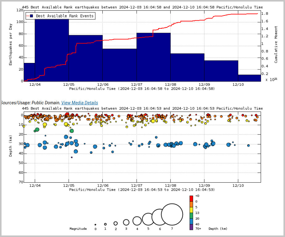
Above Top: Number of earthquakes per day during the past week (blue bars). The red line is the cumulative moment (energy) release. Bottom: Depth of earthquakes during the past week in the area shown on the map above. Depth is reported relative to sea level, which is equal to a depth of zero on the above plot. On both figures, circle-size represents magnitude, and color indicates depth. (USGS graphs)
From the Tuesday USGS HVO update:
Summit Observations: Earthquake activity at Kīlauea’s summit region was generally low over the past week. Overall, there were 120 earthquakes in the summit, all below magnitude-2.0. The tiltmeter at Uēkahuna, northwest of Kaluapele, the summit caldera, remained relatively flat with no significant changes over the past week. The tiltmeter at Sand Hill, southwest of Kaluapele, continues to show slow weak inflation (about 4 microradians over the past week). The most recent measurement of the sulfur dioxide (SO2) emission rate from the summit was approximately 70 tonnes per day on October 17, a value representative of noneruptive conditions at Kīlauea.
Rift Zone Observations: Shallow earthquake counts in the upper and middle East Rift Zone (ERZ) have returned to low levels following the small uptick last week. There were approximately 70 located earthquakes in the middle ERZ, and approximately 70 in the upper ERZ as well, with most below magnitude-2.0. Deformation remains steady in the ERZ, as recorded by GPS instruments and tiltmeters. There are no indications of any changes downrift in the lower East Rift Zone.
Analysis: Kīlauea erupted briefly in and near Nāpau Crater from September 15–20, 2024. Lava flows from this eruption covered more than 880,000 square meters (217 acres) of Nāpau Crater and areas to the west.
Since that most recent eruption, unrest has continued at low levels at the summit and on the ERZ of Kīlauea. Rates of seismicity and ground deformation have greatly decreased since the eruption, but geophysical data show that magma is continuing to move at a low rate into the volcano. Future intrusions and eruptions could occur with continued magma supply.

by Big Island Video News
on at
STORY SUMMARY
HAWAIʻI VOLCANOES NATIONAL PARK - Seismicity at Kīlauea volcano’s summit, East Rift Zone, and Southwest Rift Zone is low and deformation is steady.