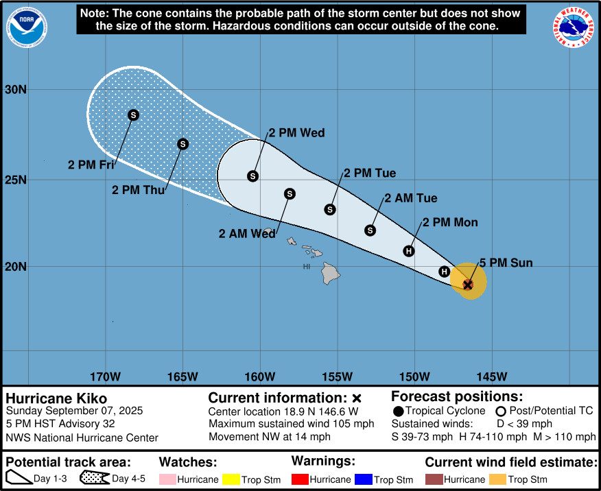
UPDATE – (5:30 p.m.) – Kiko remains a category 2 hurricane less than 555 miles east of Hilo, moving northwest at 14 mph.
“The latest National Hurricane Center forecasts continue to show Kiko weakening to a tropical storm as it passes north of the islands Tuesday and Wednesday,” the National Weather Service in Honolulu said in a 3:51 p.m. update. “Confidence in this scenario is increasing, though interests in Hawaii should continue to monitor official forecasts for Kiko. Moisture along the periphery of the system will spread over the state Monday night and Tuesday. Initially, this will provide an increase in clouds and mainly windward showers, but as trade winds become disrupted, afternoon sea breezes will likely trigger spotty interior rainfall. These showers could be locally heavy in places, and we cannot rule out a brief thunderstorm as the atmosphere destabilizes on Tuesday. As dew points creep into the low to mid 70s, rather humid conditions will prevail.”
A rapid increase of ocean swell, with surf heights possibly reaching low end High Surf Warning levels, is possible Monday night into Tuesday along east facing shores as Kiko nears the state, forecasters say.
12 p.m. Update
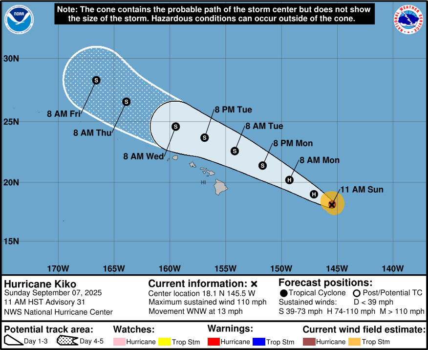
UPDATE – (12 noon) – In a 11 a.m. update from the National Hurricane Center, Hurricane Kiko was reported to be gradually weakening, 635 miles east of Hilo.
“Reports from an Air Force Reserve Hurricane Hunter aircraft indicate that maximum sustained winds have decreased to near 110 mph (175 km/h) with higher gusts,” the NHC stated. “Additional weakening is forecast during the next few days, and Kiko is expected to become a tropical storm by late Monday or Monday night.”
Kiko is expected to pass north of the Hawaiian islands on Tuesday or Wednesday.
“Due to Hurricane Kiko, the primary impact will be high surf building late Sunday through Monday to Warning level,” the Hawaiʻi County Civil Defense stated in a 10 a.m. message to Big Island residents. “The wind and rain threats are diminished as Kiko tracks north of the island. Due to the uncertainty of storm conditions please remain alert for changes to the forecast.”
FIRST REPORT
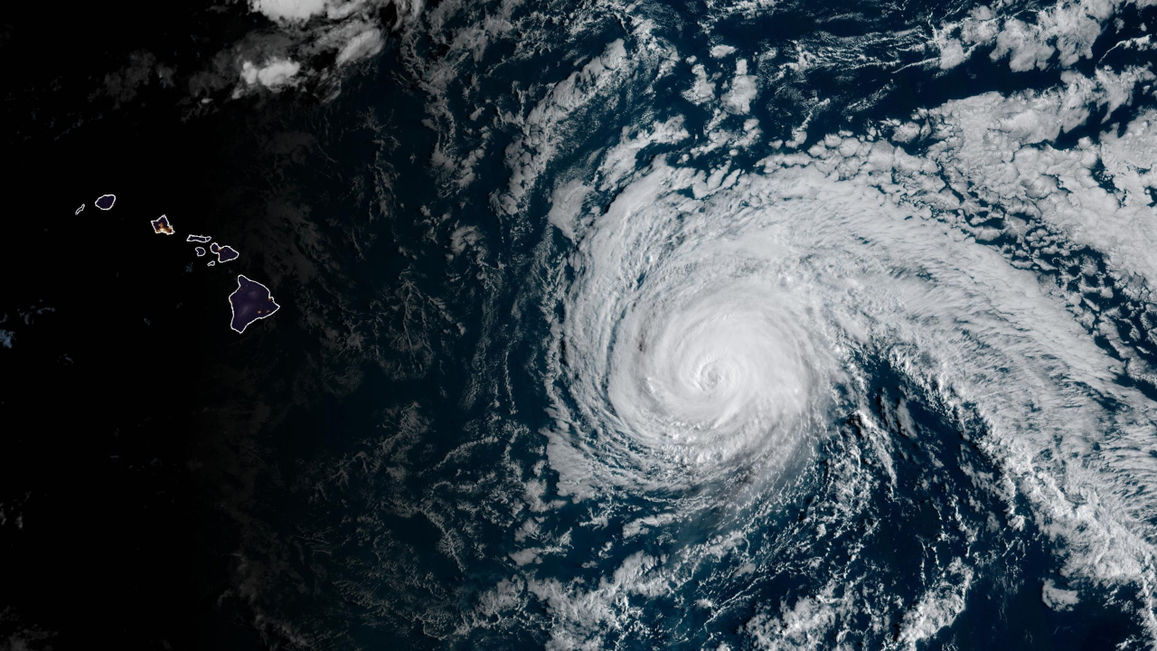
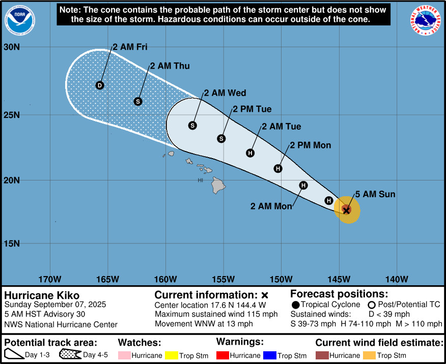
(BIVN) – After restrengthening into a category 4 hurricane on Saturday, Kiko is gradually weakening over cooler waters, 715 miles east of Hilo as of 5 a.m. on Sunday.
On Sunday morning, Kiko was category 3 hurricane on the Saffir-Simpson Hurricane Wind Scale, with maximum sustained winds decreased to near 115 mph. Kiko is moving toward the west-northwest near 13 mph.
Kiko is expected to weaken into a tropical storm on Tuesday, as it passes north of the Hawaiian Islands.
The ocean swell generated by Kiko will begin arriving today, forecasters say, “peaking at or near High Surf Warning levels along east-facing shores Monday night and Tuesday.”
“Kiko is introducing a very high precipitable water air mass of around 2 inches to the area; near max values by early September standards,” the National Weather Service in Honolulu wrote Sunday morning. “So, with a forecast north-northwest Kiko track, forecast confidence is the greatest that island weather during Kiko’s passage will transition to cloudier and more humid under very benign winds and occasional showers.”
“The greatest rainfall will likely fall along more eastern and northern upslope mauka or within higher terrain.” the forecasters wrote. “This very moist air mass moving across the islands as Kiko passes to the north, combined with weaker steering flow over the island chain, may lead to periods of heavy rain along small scale breeze boundaries.”
From the National Hurricane Center discussion posted at 5 a.m. HST:
Kiko remains a compact hurricane, although the eye has become less circular during the past few hours. Dvorak CI numbers from SAB, JTWC, and PHFO now range between 5.5-6.0 (102-115 kt), while objective numbers from UW-CIMSS are generally between 90-100 kt. Based on these estimates, the intensity is estimated to be about 100 kt. Another Air Force Reserve Hurricane Hunter aircraft is scheduled to investigate Kiko around 8 AM HST/1800 UTC.
The hurricane is on a steady west-northwestward trajectory of 300 degrees at 11 kt. A mid-level ridge lies north of Kiko, extending to about 150W, while a deep-layer low is located north of the Hawaiian Islands. The steering resulting from this pattern is expected to keep Kiko on a west-northwestward heading for the next 5 days, with some decrease in speed possible around Friday. Based on this motion, Kiko is expected to pass to the north of the Hawaiian Islands on Tuesday and Wednesday, and the most reliable track models are in good agreement on this scenario. The one main change in the forecast is that a good chunk of the guidance is showing a faster motion beyond 48 hours, and the new NHC forecast is therefore a little faster than the previous prediction at those forecast times, maintaining a forward speed of 12-13 kt through day 4.
Kiko is already moving over cool waters of about 25 degrees Celsius, which is likely causing the current weakening trend. Although vertical shear is currently low, southwesterly shear of at least 20 kt is forecast to set in over Kiko in about 24 hours. Because of the hurricane’s small size and it being embedded in a very dry surrounding environment, this shear is likely to hasten the weakening trend. The NHC intensity forecast closely follows the latest HCCA aid, dropping Kiko below hurricane strength just after 48 hours. While continued weakening is likely thereafter, there is some uncertainty as to whether Kiko will fall below tropical storm strength by day 5, as shown in the official forecast. If model trends continue to show some restrengthening, then subsequent advisories may keep tropical storm status through 5 days.
Key Messages:
1. Kiko is forecast to pass north of the Hawaiian Islands on Tuesday and Wednesday. While the risk of direct impacts on the islands appears to be decreasing, interests there should continue to monitor Kiko’s progress and the latest forecast.
2. Swells generated by Kiko are expected to begin reaching the Big Island and Maui later today. These swells will gradually build and are forecast to peak along east-facing exposures of the Hawaiian Islands late Monday through midweek, potentially producing life-threatening surf and rip currents. Listen for later advisories and possible warnings from the National Weather Service.

by Big Island Video News
on at
STORY SUMMARY
HAWAIʻI - Hurricane Kiko is expected to pass north of the Hawaiian Islands on Tuesday and Wednesday as it weakens to a tropical storm.