(BIVN) – Emergency officials are urging readiness as a powerful kona storm is expected to impact Hawaiʻi through this weekend, with the peak of the event forecast for Friday and Saturday.
“The County is working hard to get ready for this powerful storm and keep residents safe,” said Mayor Kimo Alameda in a Hawaiʻi County news release. “A storm like this can impact the entire island so we ask everyone to prepare for what this weather system can bring.”
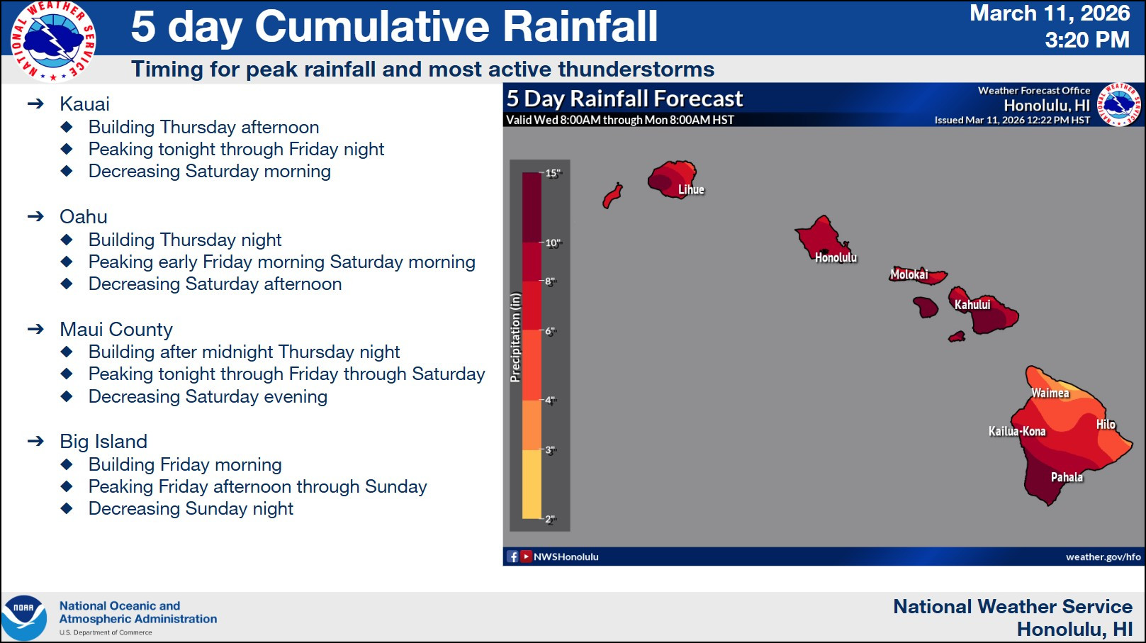
The storm will bring the potential for flash flooding, damaging winds, and strong to severe thunderstorms over the islands, beginning with the western end of the state and then spread east.
Thursday night through Saturday “represents the period of greatest concern and the potential timing for considerable impacts to life and property,” the National Weather Service reported. From a Wednesday afternoon discussion:
This period will also be characterized by intense rain rates, thunderstorms, and the potentially serious flash flooding. The most intense rainfall will be focused along the rapidly strengthening frontal zone as it slowly progresses eastward through the state. This band will develop over Kauai by late Thursday, reach Oahu during Friday and Maui County late Friday into Friday night. The heavy rain axis finally reaches the Big Island on Saturday, focusing heavy rain along leeward areas. Also suspect showers will ramp up during this time frame over the SE slopes of the Big Island potentially resulting in several inches of rain in advance of the heavy rain band. There is also a slight risk for severe thunderstorms. Wind profiles are largely unidirectional out of the SW which will favor a primary threat of wind. However, large hail (1″ diameter or greater) is also not out of the question with any particularly intense thunderstorms. It should be noted that the heavy rain band is forecast to move slowly but still be rather progressive in nature. Should it stall over an island, the threat for severe flooding would drastically increase.
Hawaiʻi County officials noted that the storm “could produce brief and weak tornadoes.”
“Some of the models we’ve seen show parts of the island could receive more than 10 inches of rain,” said Talmadge Magno, Civil Defense Administrator, in a news release. “While some areas can handle these amounts, others will have significant flooding impacts. We’ll be sharing forecast updates as we receive more information and provide direction for actions you will need to take. If you haven’t already done so, now is a great time to sign up for emergency alerts at the Hawai‘i County Civil Defense website to receive updates on your cell phone.”
A Flood Watch remains in place for entire State of Hawaiʻi. A High Wind Watch will be in effect for the entire island of Hawaiʻi on Friday morning, when southwest winds of 25 to 35 mph, with gusts up to 60 mph, are possible.
Hawaiʻi island summits could see conditions that are much more severe. Blizzard conditions will be possible atop Maunakea and Mauna Loa, where the National Weather Service has issued a Winter Storm Watch. Total snow accumulation of 12 to 18 inches are possible, and winds could gust as high as 110 mph.
The following information was provided by the County of Hawaiʻi:
Preparing Your Property
- Check around your home and trim low-hanging branches that could be downed by the winds and cause damage.
- Secure lanai furniture and other objects that could become airborne in strong, gusty winds.
- Check drainage areas, gutters, and drains to clear any debris that may block water from flowing.
- If your property is prone to flooding, consider placing sandbags to protect foundations, doorways and other vulnerable areas. Consider raising items that may be damaged by flooding to a higher level.
- Check emergency supplies, including food, water and necessary medications for people and pets.
- Be prepared for power outages. Battery-powered light sources are safer than candles or gas lanterns and less likely to start an accidental fire. If you rely on an electrically powered medical device, make sure batteries are charged and have a backup plan.
- Check and refuel electrical generators if you have them and refresh your knowledge of how to safely operate them if needed. Always locate a generator in a well-ventilated area where exhaust can’t blow back into areas occupied by people or pets.
General Safety Information
- Consider changing or delaying plans for travel or outdoor activities during inclement weather, especially routes that have low-lying areas prone to flooding.
- Know the areas that are prone to flooding, particularly those near your home, and use extra caution around them. Heavy rain uphill from your location can cause flooding, even if it’s not raining where you are.
- Never try to cross moving water, on foot or in a vehicle: “Turn around, don’t drown.”
- Monitor local forecasts from reliable sources for the latest information about the storm and its potential hazards. Have a battery- or crank-powered radio to receive information during a power outage. (Don’t forget the car radio.)
- If lightning threatens, the safest place to be is indoors. If you’re in a vehicle, stay in the vehicle, but pull off the road if rain is dangerously heavy and it is safe to pull over.
- Have a “go bag” ready in case you must evacuate the area, especially if your home is in an area prone to flooding. It should include food, water, necessary medication, important documents, and other necessities for the members of your household (including pets) if you need to leave in a hurry.
- Check in with neighbors, especially those who may have mobility problems, to make sure they have a safe way to evacuate if flooding strikes.

by Big Island Video News
on at
STORY SUMMARY
HAWAIʻI - Hawaiʻi is preparing for a powerful kona storm that is forecast to impact the state through this weekend, resulting in potential flash flooding, damaging winds, and strong to severe thunderstorms.