
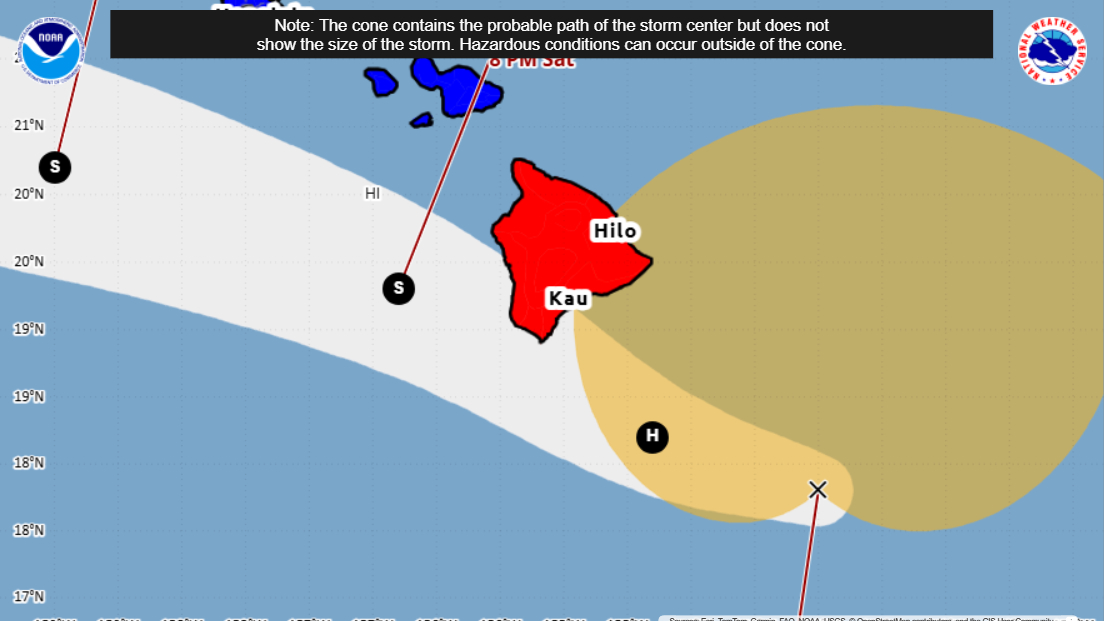

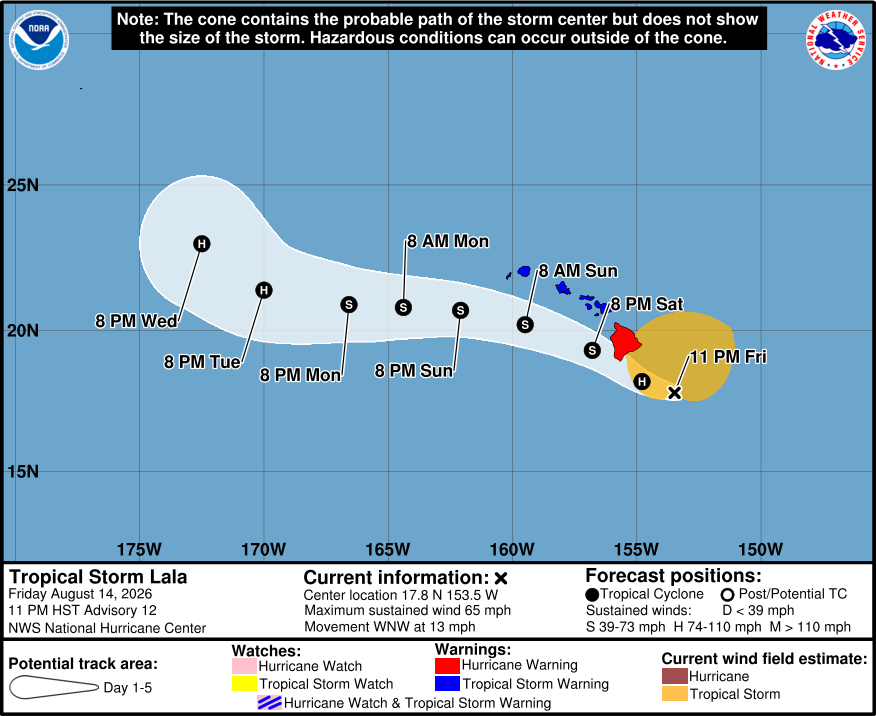
(BIVN) – As of 11 p.m. Friday evening, Tropical Storm Lala was 165 miles east southeast of South Point, moving west northwest towards Hawaiʻi island at 13 MPH. Tropical-storm-force winds extend outward up to 220 miles (350 km) from the center of the storm, which means the windfield should already be reaching over areas of Hawaiʻi island.
“Some slowing of the forward motion is possible as the cyclone approaches the Big Island and begins to interact with the island’s terrain on Saturday,” the Central Pacific Hurricane Center stated at 11 p.m. “Short-term deviations in the track are also possible during this time.”
Lala’s maximum sustained winds are near 65 mph (95 km/h) with higher gusts. Lala is still expected to strengthen into a hurricane as it approaches the Big Island Saturday.
“Interaction with the island’s terrain should then disrupt the low-level circulation and result in weakening, with modest vertical wind shear providing an additional negative influence later in the weekend as Lala passes south of the smaller islands,” stated the Central Pacific Hurricane Center.
A Hurricane Warning remains in effect for Hawaiʻi island, as well as a Flood Watch and High Surf Warning for east-facing shores.
Added to the list of closures are all state parks on Hawaiʻi island.
The Hawaiʻi DLNR says the parks will close at 4 a.m., August 15, 2026. Hawaiʻi Island forestry and wildlife lands will be closed as of 7 p.m.
“DLNR is asking for everyone’s cooperation with this announcement of area closures,” a news release stated. “People are advised to avoid forested and coastal areas due to the dangers of rising streams, flash flooding, falling trees, storm surge, or high surf.”
From the National Weather Service at 11:02 p.m. HST:
STRONG AND GUSTY WINDS… Damaging tropical storm force winds (39 mph to 73 mph) may begin as early as tonight across parts of the Big Island, Maui County as early as Saturday morning, Oahu as early as Saturday afternoon, and Kauai as early as Saturday night. A Hurricane Warning is in effect for the Big Island and surrounding waters due to a non-negligable chance of hurricane force winds (74 mph or greater). A Tropical Storm Warning is in effect for the rest of the state and surrounding waters. Localized areas of highly enhanced and damaging winds are possible over and downwind of the mountainous terrain, even well away from the tropical cyclone center. These localized strong winds and gusts will also be felt in advance of the arrival of Lala (i.e. tonight and Saturday morning) and should be kept in mind as last minute preparations are being made.
HEAVY RAINFALL… Periods of heavy rainfall are expected starting with the Big Island tonight, reaching Maui County on Saturday, and Oahu and Kauai later Saturday and Sunday. Orographic enhancement will result in locally higher rainfall totals where moist tropical flow interacts with island terrain. If heavier rainfall persists over the same locations, flash flooding and rapidly rising streams are possible. The location of heaviest rain currently favors the Big Island and parts of Maui. The current forecast has 10 to 15 inches of rain, with locally higher amounts across windward Big Island. Rainfall totals of 8 to 12 inches are possible on windward Maui and up 8 inches of rainfall could occur across the remainder of the island chain. While the highest rainfall amounts will be focused over windward areas, leeward areas will also have a significant flood risk. Heavy rain could persist into Monday for some areas. A Flood Watch has been issued for the Big Island and Maui County from tonight through late Saturday night, and for Oahu, Kauai, and Niihau from Saturday evening to early Monday morning.
LARGE AND ROUGH SURF… Lala is expected to generate a large easterly swell as it moves northwestward. Surf may build along exposed east and southeast facing shores from east to west as the system approaches. A High Surf Warning is posted for east facing shores of Big Island, Maui, Molokai and Oahu, and a High Surf Advisory is posted for east facing shores of Kauai. Very large and extremely rough seas are expected to rapidly increase Saturday and Sunday on exposed southeast and east shores and may produce damaging surf, significant beach erosion, and overwash across vulnerable coastal infrastructure, mainly on the Big Island of Hawaii. Highest storm surge up to 3 feet is forecast for the eastern side of the Big Island.
