
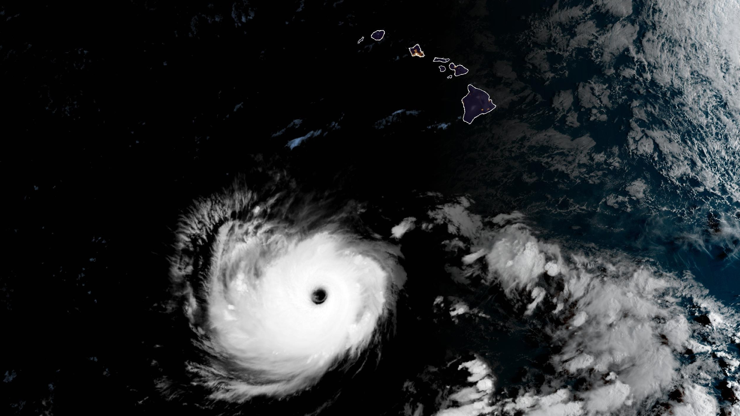

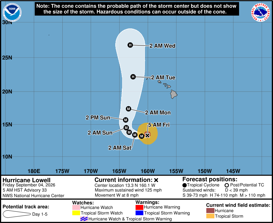
(BIVN) – Major Hurricane Lowell was 570 miles south-southwest of Oʻahu as of 5 a.m. Friday morning, moving west at 8 mph.
With maximum sustained winds near 125 mph, Lowell is a category 3 hurricane on the Saffir-Simpson Hurricane Wind Scale. Some re-strengthening is forecast during the next couple of days, the Central Pacific Hurricane Center says.
Lowell is still expected to decrease in forward speed, and then make a sharp turn to the north on Sunday.
“Hurricane Lowell will remain near major hurricane strength when it moves closer to the western Hawaiian Islands late Monday and Monday night,” reported the National Weather Service on Friday morning. “There remains a risk for high surf, storm surge, strong winds and heavy rainfall impacts for portions of Hawaii including in particular the islands of Niihau and Kauai.”
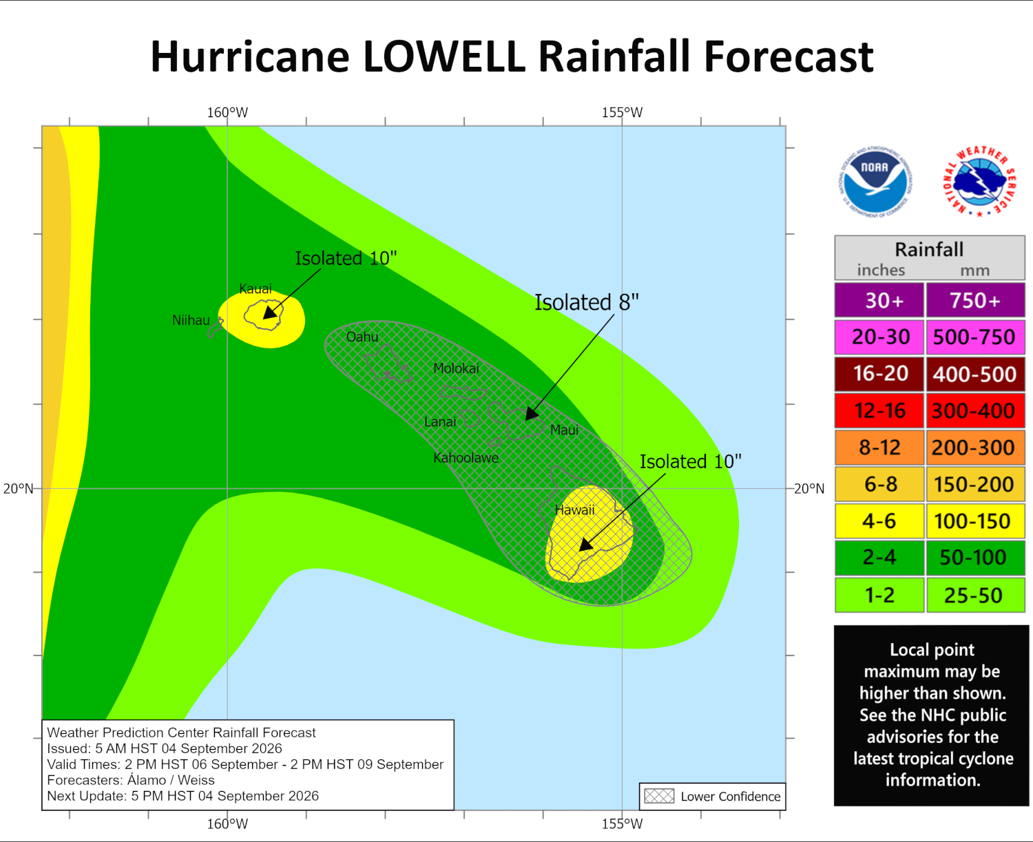
Heavy rain is expected to follow Lowell as it nears Hawaiʻi.
“Deep tropical moisture will advect northward across all island, producing warm and humid weather conditions with increasing heavy rainfall trends from Sunday into Tuesday as Hurricane Lowell turns northward,” the Honolulu-based forecasters said. “Initial storm total rainfall estimates range from 2 to 8 inches statewide with locally higher amounts of around 10 inches possible along terrain favored south and southeast slopes. Please continue to closely monitor the weather forecast for early next week as the track and associated impacts with Hurricane Lowell will likely evolve over time.”
On Thursday, Governor Josh Green signed an emergency proclamation, with plans to send six high-water vehicles are being sent to Kauaʻi. “Hawaiʻi National Guard members will be activated in advance of potential storm impacts,” the Office of the Governor stated. “The proclamation allows state and county agencies to mobilize personnel, equipment and resources more quickly as Hawaiʻi continues recovering from Tropical Cyclone Lala.”
“Our state is still recovering from Lala, and we are not waiting for another storm to get close before preparing,” said Governor Green. “This proclamation gives our agencies and counties the flexibility to move people, equipment and resources quickly so we can protect communities across every island. We encourage everyone to remain prepared and continue following official weather updates.”
From the Central Pacific Hurricane Center discussion at 5 a.m. HST:
There has not been any significant changes with Lowell over the past several hours. The major hurricane is maintaining an eye in satellite imagery with an intense ring of deep convection around the center. The convective pattern is a little asymmetric with the strongest thunderstorms currently occurring south of the center. The latest satellite intensity estimates range from 102 to 120 kt, and based on that data, the initial wind speed is held at 110 kt. The Air Force Hurricane Hunters are scheduled to investigate Lowell later today, and the information they collect will be very helpful in assessing the cyclone’s intensity and structure.
Lowell has been losing some latitude this morning, with the initial motion estimated to be just south of due west, or 265/7 kt. A general westward motion is expected through Saturday as Lowell remains steered by the flow on the southeastern side of a mid-level ridge. On Sunday, the steering pattern is expected to change when a mid- to upper-level low moves southwestward north of the Hawaiian Islands, eroding the southern portion of the ridge. This pattern change should cause a sharp turn to the north or north-northeast with a gradual increase in forward speed, bringing the system close to the westernmost Hawaiian Islands on Monday and Monday night. It should be noted that predicting where and how sharply Lowell turns is challenging as it will depend on the location and amplitude of the mid- to upper-level low relative to the hurricane’s location. Although the models agree on the overall setup and all show Lowell turning, there is a notable amount of spread on how close the core of Lowell gets to Kauai County. This forecast is quite similar to the previous one and near a blend of the best-performing aids so far this season, the Google DeepMind ensemble mean and consensus aids HCCA and TVCN.
The atmospheric and oceanic conditions are expected to be conducive for strengthening over the next two to three days, and it seems likely that Lowell will restrengthen back to a category 4 hurricane during that period. Beyond that time, a notable increase in southwesterly vertical wind shear and cooler waters should cause steady weakening. However, Lowell is still forecast to be near major hurricane strength when makes its closest approach to the Hawaiian Islands. The NHC intensity forecast lies near the high end of the model guidance, in best agreement with HCCA.
KEY MESSAGES:
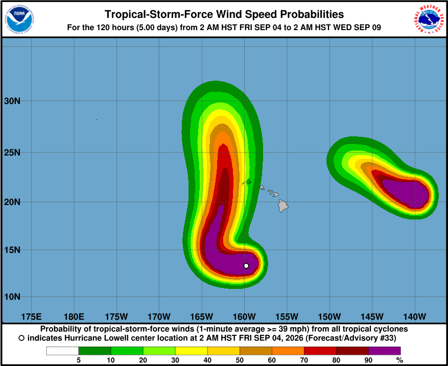
1. Lowell could be near major hurricane strength when it moves close to the western Hawaiian Islands late Monday and Monday night. Regardless of the hurricane’s exact track and intensity, there is a risk of storm surge, wind, and rainfall impacts for portions of Hawaii, particularly Kauai County, early next week.
2. Interests in Hawaii should continue to closely monitor the progress of Lowell through the upcoming Labor Day weekend, listen to the advice of local officials, and ensure they have their hurricane plan and supply kit in place. Watches are likely to be issued for a portion of the state on Saturday.
3. Swells from Lowell are likely to cause life-threatening surf and rip current conditions in portions of the Hawaiian Islands during the next several days. These swells are likely to increase early next week.
