
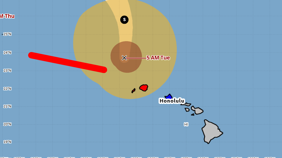

(BIVN) – As of 5 a.m. Tuesday morning, Hurricane Lowell was 145 miles northwest of Lihue, and moving north, away from the Hawaiian islands, at 18 mph.
Lowell battered the islands of Niʻihau and Kauai overnight. There have been reports of downed trees, severe flooding, roofs lifted off homes, and at least one report of “a house blown off its foundation and into a neighbors yard.”
The Hurricane Warning continues for Kauai County this morning, as well as the Tropical Storm Warning for Oʻahu.
A Flood Watch is in place for the entire state, with a High Surf Warning in effect for west facing shores.
“A Flood Watch remains in effect for the entire state through this afternoon as Lowell brings deep moist southerly flow across the islands,” the National Weather Service stated. “Mid to late week, both the GFS and ECMWF show the trailing band of deep moisture lingering over the eastern half of the state. Confidence is increasing that the Flood Watch will need to be extended for Big Island and possibly Maui County to cover any additional enhancement of shower activity.”
“Diurnal heating, combined with a relatively deep moisture layer will also allow for a slight chance of thunderstorms over interior Big Island both this afternoon and Wednesday afternoon,” the Honolulu-based forecasters said.

From the Central Pacific Hurricane Center discussion posted at 5 a.m. HST:
Lowell is quickly weakening. Satellite images indicate that the center is exposed on the southern side of a decreasing area of deep convection. While recent flight-level aircraft wind data did not show much weakening aloft, dropsondes suggested that these high winds were not making it to the surface as typical, probably due to the lack of local convection. The initial wind speed is set to 80 kt, a compromise of higher aircraft data and lower satellite fixes from JTWC and HFO.
The hurricane is moving quickly northward at about 16 kt. Lowell should gradually turn westward and slow down during the next couple of days as the mid- to upper-level trough steering the hurricane weakens and a mid-level ridge to builds in to the north. At long-range, another trough is forecast to interact with Lowell, which could cause it to accelerate to the northwest. The new track forecast is very similar to the previous advisory, close to the latest Google DeepMind and HCCA aids.
Lowell should continue to quickly weaken today due to high shear, likely becoming a tropical storm by the evening. A slow weakening is expected then through late week due to marginally warm waters and some shear, and Lowell could be close to becoming a post-tropical cyclone on Friday. However, the next trough could re-energize the deep convection, with a fair number of models showing modest re-strengthening over the weekend. The new forecast is reduced in the short term due to the poor initial structure, then is blended with the previous one. The end of the forecast should be considered very uncertain given the aforementioned trough interaction.
KEY MESSAGES:
1. Kauai County: Hurricane conditions will continue for the next few hours, with the highest winds atop mountains and on windward and leeward slopes, causing widespread power outages. If you use a generator, be sure it is placed at least 20 feet away from doors, windows, and garages to avoid deadly carbon monoxide poisoning.
2. Periods of heavy rainfall associated with Hurricane Lowell will continue over the Hawaiian Islands through Wednesday. This may produce significant flash flooding and mudslides, especially across Kauai county and portions of the Big Island.
3. Oahu: Tropical storm conditions are expected for the next few hours. Strong wind gusts could cause downed trees and power outages, especially in areas of higher terrain.
4. Large waves will continue to produce life-threatening surf and rip current conditions during the next day or so along exposed coasts of the Hawaiian Islands.
