
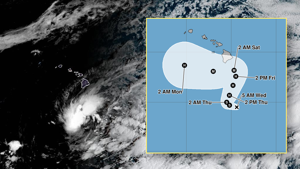

(BIVN) – Hawaiʻi officials are closely monitoring a redeveloped Tropical Depression Fifteen-E, which is expected to approach Hawaiʻi island as a major hurricane this weekend.
As of 5 a.m. Wednesday morning, the storm was about 320 miles south-southeast of South Point, moving west northwest at a slow 6 mph. The Central Pacific Hurricane Center says the system is expected to become a tropical storm later today, “with further strengthening to a hurricane likely on Thursday and possibly a major hurricane by this weekend.”
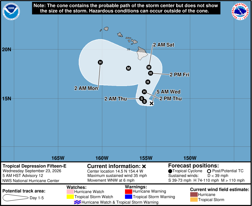
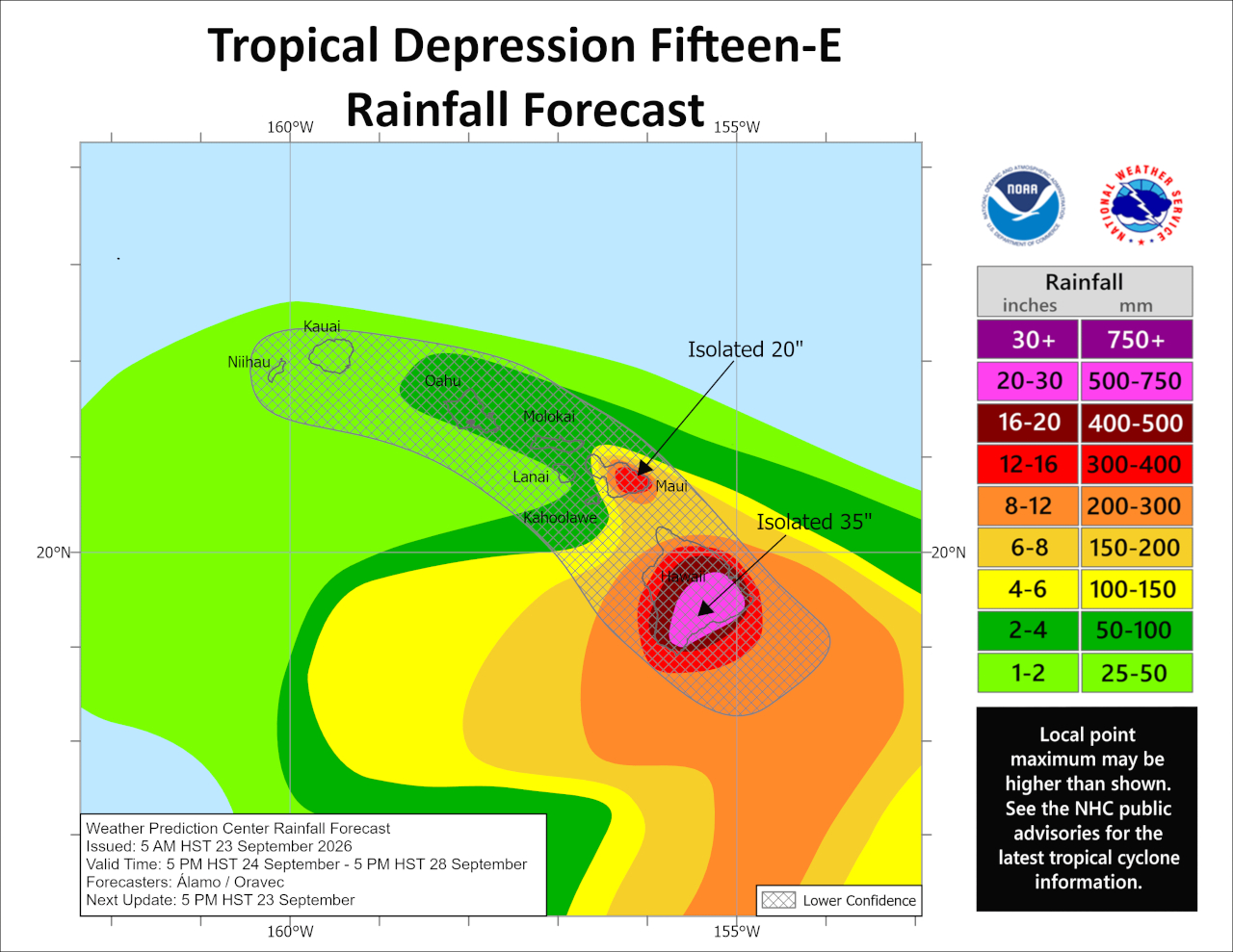
By early Saturday, the potential Hurricane Nolo could bring damaging winds and catastrophic flooding to the Big Island, which one month ago was impacted by passing Hurricane Lala. Forecasters say maximum amounts of 35 inches of rain will be possible in some areas.
Governor Josh Green plans to hold a press conference on Wednesday concerning the developing situation, where he will also address the continuing recovery efforts in the wake of the previous storms this busy hurricane season.
From the Central Pacific Hurricane Center at 5 a.m. Wednesday:
Satellite imagery shows that the depression is becoming better organized. Banding features are becoming more defined on the western and northern sides of the system, with expanding outflow noted. However, the low-level circulation appears to be on the southeastern edge of the deep convection and isn’t well aligned with the deep convective mass. Satellite intensity estimates have a large spread this morning, from about 25-40 kt. Without definitive evidence it has become a tropical storm, the initial wind speed will stay 30 kt, which is also consistent with winds from a recent OSCAT scatterometer pass.
The depression has slowed since the last advisory and seems to be moving west-northwestward at about 5 kt. A ridge to the northeast of Hawaii is forecast to weaken and slide eastward as a mid-latitude trough drops over the northwestern Hawaiian islands. This evolution is likely to the cause the cyclone to slow down later today or tonight and then turn northward or north-northeastward by tomorrow with some increase in forward speed. The trough is forecast to move westward this weekend as the ridge rebuilds north of Hawaii, which should force a sharp westward turn while the cyclone is close to the Big Island. At this time frame, it is impossible to know exactly when that turn will happen and, unsurprisingly, there is a large north-south spread in the guidance. Our best guidance is on the northern side of the track envelope, and new NHC forecast remains essentially the same as the last advisory. Interests in the Hawaiian Islands, especially on the Big Island, should closely monitor the system, with life-threatening catastrophic flooding possible over the steep terrain on this track.
The depression should intensify slowly at first, given the current structure of the low-level center not co-located with the mid-level circulation as seen on satellite. However, after the system develops an inner core, the environment seems conducive for significant strengthening, with low shear, high mid-level moisture and SSTs from 28-29C. The rapid intensification probabilities are increasing, and the best model guidance is showing this as a major hurricane in a few days. Given the environment and the best-performing aids (Google DeepMind and HCCA) again showing major-hurricane strength, the NHC forecast is raised from the previous one and shows the cyclone as a major hurricane when it approaches the Big Island of Hawaii by the weekend.
Key Messages:
1. Tropical Depression Fifteen-E is expected to strengthen into a tropical storm later today and a hurricane on Thursday as it turns northward, potentially making its closest approach to the Big Island of Hawaii on Saturday. There is an increasing risk of wind and wave impacts in the Hawaiian Islands, and a Hurricane Watch may be required for the Big Island later today.
2. The time to prepare for significant heavy rain and flooding impacts on the Big Island is now, as heavy rain becomes more likely by Thursday and Friday. Periods of heavy rain are likely to continue across the Big Island and Maui through the weekend. Life-threatening, catastrophic flooding and mudslides are possible, especially in areas of steep terrain across the Big Island and Maui. Across the remainder of Hawaii, lesser rainfall totals are expected, with isolated flooding possible.
3. Interests in Hawaii should closely monitor the latest forecast updates and ensure that they have their preparedness plan in place.
