
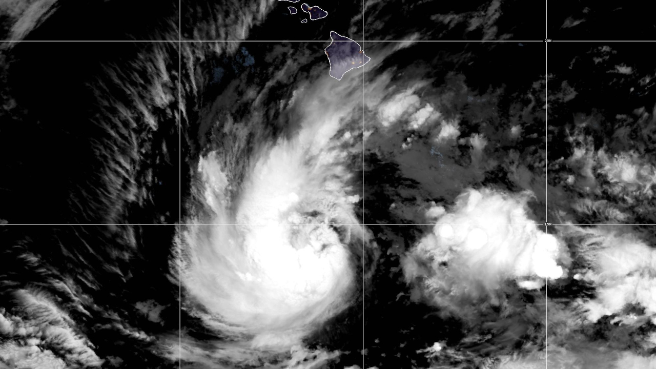

(BIVN) – Tropical Storm Nolo continues to strengthen, 285 miles south of Hawaiʻi island.
The Central Pacific Hurricane Center reported Nolo was “stationary” at 5 a.m. Thursday morning, with no movement in any direction. The storm is still expected to become a major hurricane by the weekend as it nears Hawaiʻi island to the south.
Hawaiʻi County remains under a Hurricane Watch, as well as a Flood Watch.
“The bulk of the deeper moisture along the northern periphery of Nolo has remained just south of the Big Island coastal waters overnight, which has resulted in mainly light to moderate rain rates on windward Big Island,” the National Weather Service reported this morning. “Most sites in this area have measured less than 1 inch of rainfall during the past 12 hours, though a few gages upslope of Hilo picked up 1.5 to 2 inches. The bulk of model guidance shows little change in rainfall through morning followed by increased chances of heavy showers this afternoon or evening.”
“Significant impacts could develop as early as Friday, mainly across the eastern end of the island chain, and will likely continue into the weekend,” the Honolulu-based forcasters wrote. “The National Hurricane Center track contains more uncertainty than normal, but confidence is high that Nolo will be at hurricane strength as it nears Big Island late Friday and eventually turns toward the west Saturday.”
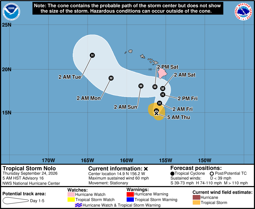
From the most recent Central Pacific Hurricane Center discussion, posted at 5 a.m. Thursday morning:
Satellite images indicate that Nolo is gradually becoming better organized, with very deep convection in a curved band on the southern and western side of the circulation. Additionally, a GPM pass from overnight indicated that an inner core is forming, although the eastern side is fragmented. Intensity estimates are rising, and the current wind speed is set to 50 kt as a blend of the lower subjective and higher objective values.
Nolo has not moved much during the last several hours but should begin to move northward and north-northeastward later today due to a mid-latitude trough dropping over the northwestern Hawaiian Islands. The trough is forecast to move westward by Saturday with a building ridge north of the main Hawaiian Islands, causing a sharp westward turn this weekend. The big question is how close does Nolo get before making that turn, with notable run-to-run inconsistencies in much of the guidance. Similar to the lastcycle, the bulk of the models have shifted slightly northward, and the new NHC forecast is moved in that direction. This remains a more uncertain forecast than normal given the large unresolved north-south spread, with other possible complicating terrain influences of the Big Island (like we saw with Hurricane Lala last month). Therefore, the long-range portion of the forecast is essentially unchanged.
With the formation of an inner core, conditions appear to be coming together for rapid intensification given the other conduciveenvironmental factors of warm SSTs, low shear and high mid-levelmoisture. Nolo is likely to become a hurricane by tonight and reach major hurricane strength as it nears the Big Island on Saturday. The new forecast is raised from the previous one, just below the HCCA aid, which has done well this year in these strengthening episodes. Note that a track closer to the Big Island could substantially increase the threat of damaging winds, particularly over higher terrain, along exposed ridges, and in areas downwind of the ridges.
Key Messages:
1. Nolo is expected to strengthen into a hurricane today as it moves northward to north-northeastward, potentially making its closest approach to the Big Island of Hawaii as a major hurricane on Saturday. A Hurricane Watch remains in effect for the Big Island, and residents there should follow advice given by local officials, including evacuating if told to do so. A Hurricane Warning will likely be required for the Big Island later today.
2. The time to finish preparations for significant heavy rain and flooding impacts on the Big Island is now as heavy rain increases in both coverage and intensity today and Friday. Periods of heavy rain are expected to continue across the Big Island and Maui through the weekend. Life-threatening, catastrophic flooding and mudslides are possible, especially in areas of steep terrain across the Big Island and Maui. Across the remainder of Hawaii, lesser rainfall totals are expected, with isolated flooding possible.
3. Large and damaging waves are possible along portions of the Big Island’s coastline into the weekend.
4. Interests elsewhere in Hawaii should closely monitor the latest forecast updates and ensure that they have their preparedness plans in place. Tropical Storm Watches may be required for other islands later today or on Friday.
