
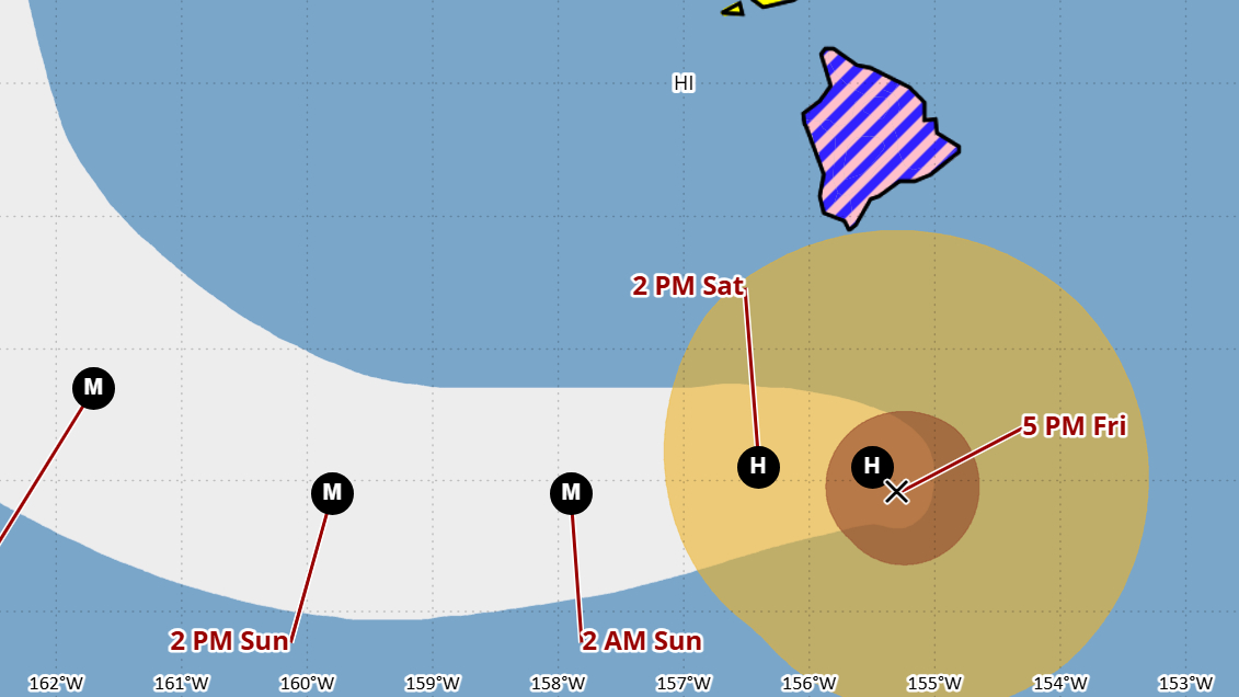

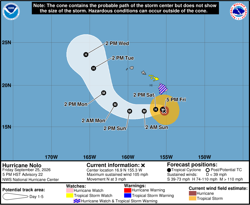
(BIVN) – Hurricane Nolo was located 145 miles south of Kaʻū as of 5 p.m. Friday evening, moving north at a slow 3 mph. Nolo is a category two hurricane, with maximum sustained winds near 105 mph.
A Tropical Storm Warning and Hurricane Watch remain in place for Hawaiʻi County. Tropical storm conditions are expected to begin by late Friday in the warning area, with hurricane conditions possible by early Saturday. Nolo is expected to make a westward turn on Saturday, well before it reaches Hawaiʻi island.
As of Friday morning, Nolo’s hurricane-force winds were extending outward up to 45 miles from its center, and tropical-storm-force winds were extending outward up to 140 miles.
Hurricane Nolo’s outer rain bands are beginning to affect Hawaiʻi island this evening. As of 3:30 p.m. Friday, the Hawaiian Electric company reported no major power outages on Hawaiʻi Island. “However, saturated ground conditions from recent rainfall continue to increase the risk of falling trees and vegetation-related damage to electrical equipment, even in areas not experiencing the strongest winds,” the utility added.
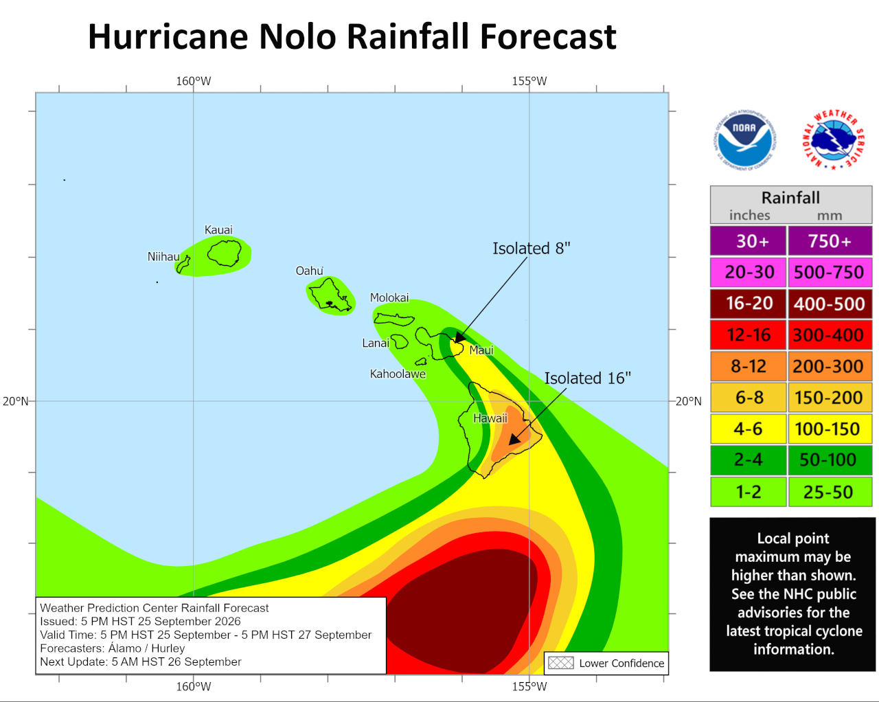
The maximum amount of rainfall to be expected from Nolo has been lowered once again, from 25 inches on the high end down to 16 inches. “This rainfall could produce significant, life-threatening flooding and mudslides, especially in areas of steep terrain,” forecasters said.
From the Central Pacific Hurricane Center’s most recent discussion posted at 5 p.m. HST:
The satellite appearance of Nolo has changed little since the last advisory. However, WSR-88D radar data from South Point, Hawaii, indicates that the eye has contracted to a diameter of about 35 n mi. While this suggests some strengthening has occurred, the Doppler velocities have changed little since the last advisory. Based on a blend of earlier aircraft data, satellite intensity estimates, and radar velocities, the initial intensity is held at 90 kt. Shear analyses show that Nolo is being affected by 10-15 kt of southeasterly shear, and this may be helping to advect dry air into the circulation as seen in the radar data.
The initial motion is now 010/3. The guidance is in excellent agreement that Nolo should stall and then turn westward in the next 12 h or so as mid- to upper-level ridge builds westward north of the Hawaiian Islands. The track guidance has shifted southward since the last advisory, and the first 60 h of the forecast track are near the northern edge of the guidance envelope. After 60 h, the hurricane is forecast to turn northward between the ridge and the mid- to upper-level trough currently northwest of Hawaii. By 120 h, there is some divergence in the track guidance due to how the tropical cyclone and the trough interact. For now, this portion of the forecast track is similar to the previous track.
Due to the shear and the apparent dry air entrainment, the new intensity forecast has a slower development rate during the first 12-24 h. From 24-72 h, the HAFS models continue to forecast Nolo to become a major hurricane. However, the SHIPS models forecast no strengthening whatsoever, and instead they forecast the cyclone to slowly weaken through the forecast period. This portion of the intensity forecast will lean towards the HAFS models, but it has increasing uncertainty. After 72 h, weakening is expected due to the forecast strong southwesterly shear east of the aforementioned trough.
Key Messages:
1. Nolo is expected to remain south of the Big Island of Hawaii through Saturday before turning westward and moving away from the island. Tropical storm conditions are expected to begin on the Big Island tonight with hurricane conditions possible on Saturday, particularly in areas of steep terrain. Residents should follow advice given by local officials, including evacuating if told to do so.
2. The time to finish preparations for significant heavy rain and flooding impacts on the Big Island is now as heavy rain increases in both coverage and intensity late today. Periods of heavy rain are expected to continue across the Big Island and Maui through the weekend. Life-threatening, catastrophic flooding and mudslides are possible, especially in areas of steep terrain across the eastern and southern portions of the Big Island and Maui. Across the remainder of Hawaii, lesser rainfall totals are expected, with isolated flooding possible.
3. Large and damaging waves are likely along portions of the Big Island’s coastline into the weekend.
4. A Tropical Storm Watch is in effect for Maui County where tropical storm conditions are possible beginning on Saturday. Interests elsewhere in Hawaii should closely monitor the latest forecast updates and ensure that they have their preparedness plans in place. Regardless of the exact track of Nolo, strong and gusty winds are expected for all of the Hawaiian Islands through the weekend.
