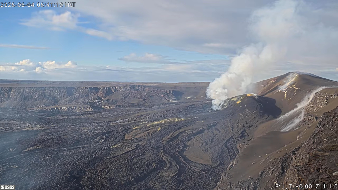
Image of the Kīlauea summit from USGS V1cam on Thursday morning.
Kīlauea Volcano Update for Thursday, June 4
Big Island Video News
Jun 4, 2026
STORY SUMMARY
HAWAIʻI VOLCANOES NATIONAL PARK - The USGS Hawaiian Volcano Observatory has published two new maps, and given an estimate for episode 49.
(BIVN) – The eruption at the summit of Kīlauea volcano remains paused. The re-inflation that started up following the conclusion of episode 48 continues, indicating another lava fountaining is likely.
The USGS Hawaiian Volcano Observatory stated on Wednesday that preliminary forecast models indicate that the onset of fountaining episode 49 is 10-15 days from now.
The crater has been “very steamy” over the last few days due to recent heavy rain. “Robust degassing plumes are visibly emanating from both vents in Halemaʻumaʻu during the day,” the Observatory noted.
The Observatory also posted two new maps of the Kīlauea summit in the wake of episode 48.
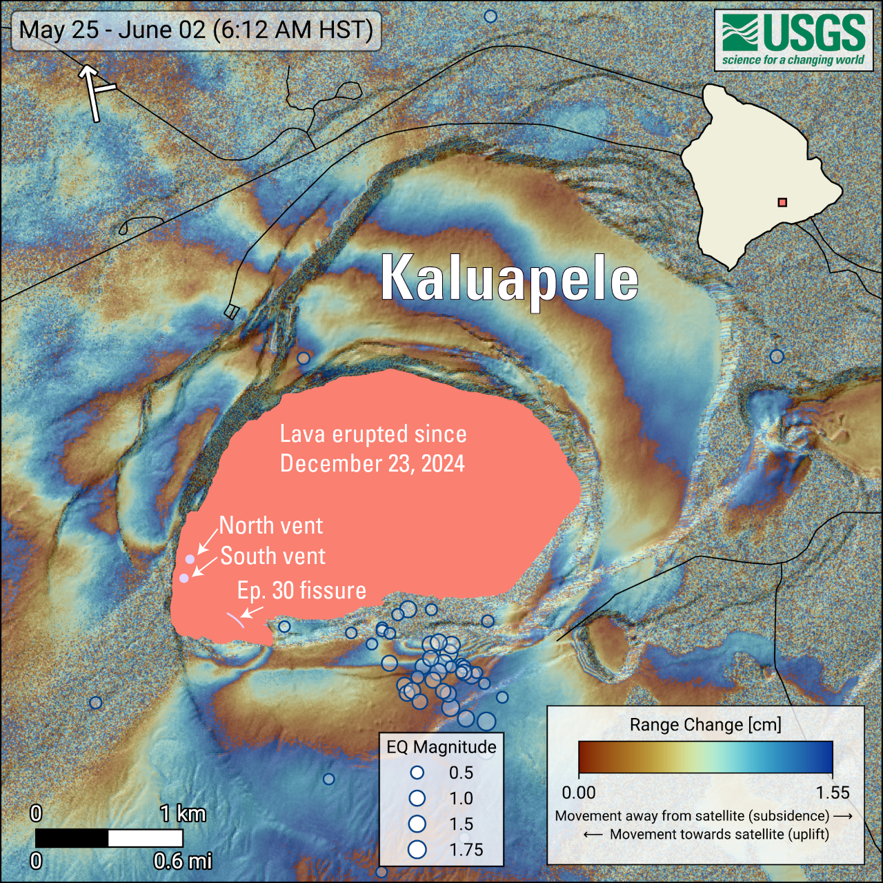
USGS: “COSMO-SkyMed Second Generation (CSG) interferogram for the period from May 25 to June 2, 2026, covering Kīlauea volcano’s summit region. Each color fringe represents 1.55 centimeters (0.61 inches) of ground movement in the direction between the satellite and the ground (range change). The symbol in the upper left indicates the satellite’s orbit direction (arrow) and look direction (bar). Earthquakes are marked with circles with the size proportional to their magnitude. The lava flows covering the crater floor are represented by the pink polygon, the two vents (circles) and the Episode 30 fissure (line) are marked in light pink.”
“As episode 48 of lava fountaining in Halemaʻumaʻu at Kīlauea summit was ending on June 1, 2026, 53 earthquakes, most smaller than magnitude-2, occurred at depths up to 1 mile (1.5 km) below the ground surface beneath the south rim of Halema’uma’u crater,” the Observatory noted in a map caption. “An area along the south rim of Halemaʻumaʻu also rose by several inches (centimeters). The specific cause of that uplift remains uncertain but it could be related to magma movement.”
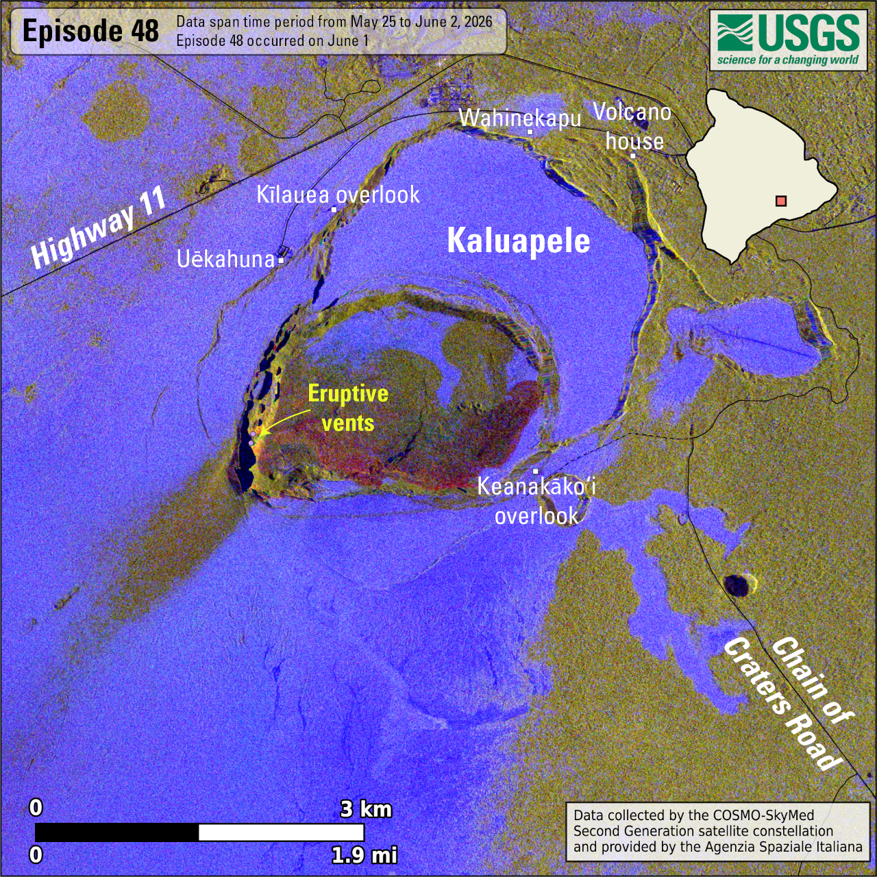
USGS: “This map shows lava flow and tephra accumulation at the summit of Kīlauea volcano associated with episode 48 of the ongoing eruption in Halemaʻumaʻu that started on December 23, 2024, using data recorded by the Italian Space Agency’s (ASI) COSMO-SkyMed Second Generation satellite constellation. These maps combine cross-polarized radar amplitude images taken on two different dates (on May 25 and June 2, 2026), along with interferometric coherence from the time between those dates. In the maps, unchanged barren areas are represented in blue/purple, vegetated areas appear in yellow/light green, new deposits over barren land are shown in dark green, and the recent lava flows in red. Public viewing areas within Hawaiʻi Volcanoes National Park are indicated with white squares; these can be temporarily closed for public safety.”
About The Featured Image
Robust degassing plumes, visibly emanating from both vents in Halemaʻumaʻu at the summit of Kīlauea, on Thursday morning. Image from USGS V1cam.
Big Island Video News has been serving Hawaiʻi island since 2008.