
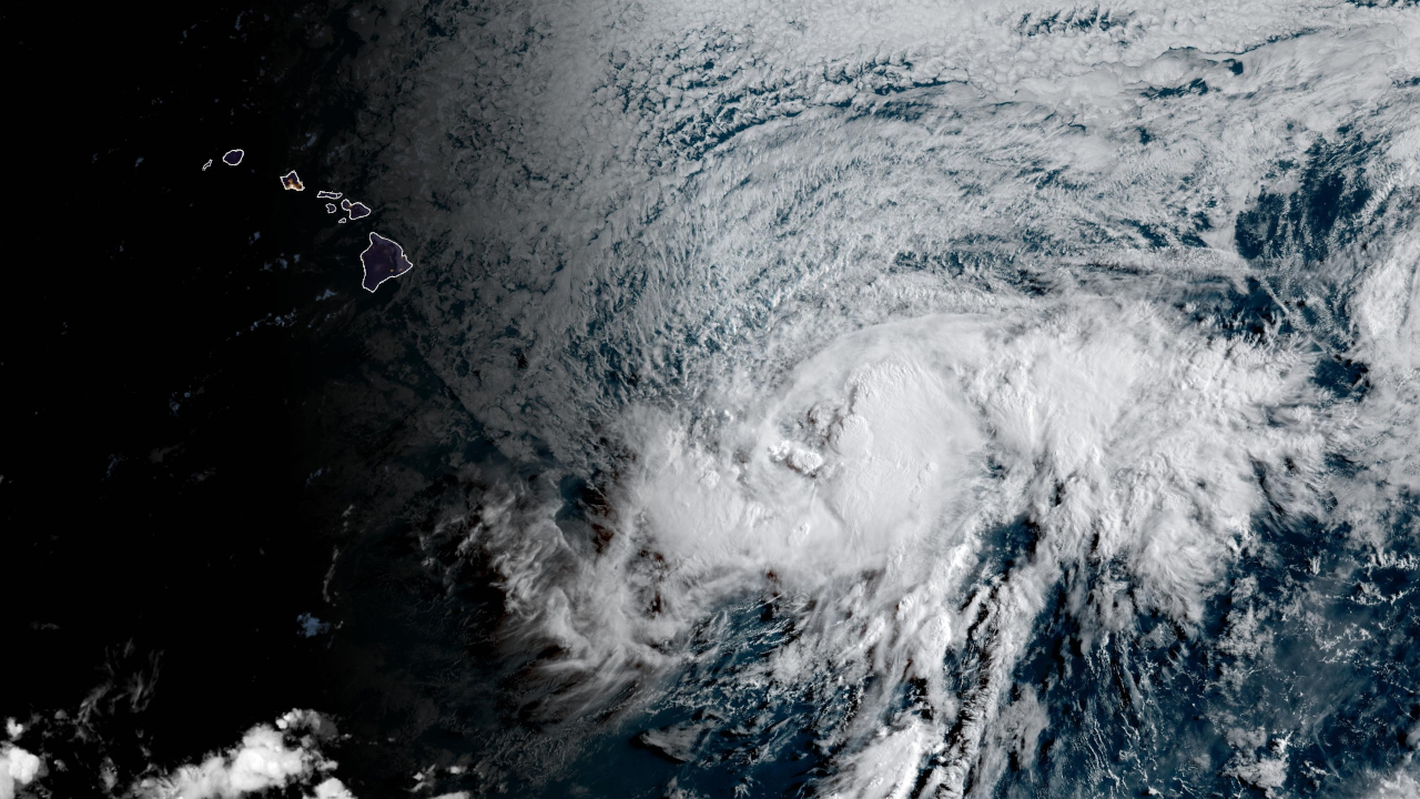

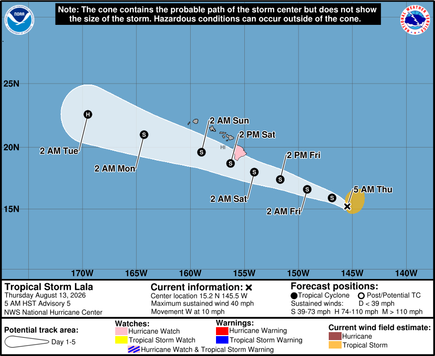
(BIVN) – Tropical Storm Lala has formed in the Central Pacific, and as of Thursday morning at 5 a.m. was located 705 miles east southeast of Hilo.
A Hurricane Watch has been issued for Hawaiʻi island. The National Weather Service says a Hurricane Watch means that hurricane conditions are possible within the watch area, and is typically issued “48 hours before the anticipated first occurrence of tropical-storm-force winds, conditions that make outside preparations difficult or dangerous.”
Hurricane conditions are possible in the Big Island of Hawaii by early Saturday. On the forecast track, Lala is expected to maintain strong tropical storm level strength as it passes near Hawaiʻi, but “there is some very skillful guidance, including the Google DeepMind and HCCA that show it becoming a category 1 hurricane during that time,” the Central Pacific Hurricane Center says.
Heavy rainfall will begin to impact the Big Island Friday, spreading westward across the island chain during the weekend. As of now, forecasters expect to see widespread rainfall of 5 to 10 inches, with locally higher amounts will be possible, especially over the windward areas of Maui and the Big Island. Maximum totals of 20 inches are possible.
A 1 to 3 foot storm surge is also possible along coastal areas. “The deepest water will occur along the immediate coast, where the surge will be accompanied by large and dangerous waves,” the National Weather Service says.
Swells generated by Lala are expected to reach the east-facing shores of the state on Friday.
The U.S. Coast Guard Captain of the Port increased port heavy weather conditions to X-ray for the commercial ports of Maui County and Hawaii County. The commercial ports of Honolulu County will be set to X-ray later this morning. All transfer operations may continue while X-Ray remains in effect, the USCG says, although all vessels should prepare to complete cargo operations and depart port within 36 hours.
From the National Weather Service discussion posted at 5:26 a.m. HST:
Interests within the main Hawaiian Islands should closely monitor for forecast updates and prepare for the potential impacts described below.
FIRE WEATHER…Fire weather concerns will increase on Friday ahead of any potential tropical cyclone`s arrival. Winds will begin to strengthen while a dry and stable air mass with low relative humidity moves overhead. This combination of lower relative humidity and increasing wind speeds will likely lead to high wildfire risk, though confidence is not high enough at this time to issue any fire weather headlines for Friday.
STRONG AND GUSTY WINDS…Winds could strengthen further on Saturday, though the timing, direction, and magnitude of the strongest winds remain highly dependent on the track and intensity of the system. With the past few cycles, the track forecast for Layla have nudged a bit farther south. However, even if the center of the system remains away from the islands, the north semicircle of the storm will still produce damaging winds. For now, confidence is highest in wind impacts for the Big Island and surrounding waters. Therefore, a Hurricane Watch has been issued for the Big Island and its surrounding waters. Although the official intensity forecast at this time from NHC keeps Lala as a high end Tropical Storm as it passes near the Big Island, there is enough uncertainty in the forecast to warrant the Hurricane Watch at this time.
HEAVY RAINFALL…This system could bring periods of heavy
rainfall, particularly across east and southeast-facing slopes. Orographic enhancement could result in locally higher rainfall totals where moist tropical flow interacts with island terrain. If heavier rainfall persists over the same locations, flash flooding and rapidly rising streams are possible. Again, the location of heaviest rain and any bands that would move through the islands will be highly dependent on the system`s track, which currently favors the highest rainfall totals for the Big Island and Maui County (though the remaining islands could also experience heavy rain bands as well). The current forecast has 5-10 inches of rain with locally higher amounts Friday through the weekend. As far as timing, heavy rainfall is currently forecast to impact the Big Island as early as Friday, spreading to Maui on Saturday, and Lanai, Molokai, Oahu, and Kauai on Saturday night into Sunday. A Flood Watch may be needed for at least portions of the state.LARGE AND ROUGH SURF…Lala is expected to generate a large easterly swell as it moves northwestward. Surf may build along east-facing shores from east to west as the system approaches, with warning level surf of 15 feet or larger possible into the weekend.
From the Tropical Storm Lala Discussion posted by the Central Pacific Hurricane Center at 5 a.m. HST:
Over the past several hours, deep convection has been increasing near the center and in bands on the north side of the system. In addition, the circulation appears less elongated and more consolidated. Based on the improvement in its appearance, the system now meets the criteria of a tropical storm. The initial intensity of Lala is estimated to be 35 kt, which is near the middle of the latest satellite intensity estimates. An Air Force reconnaissance aircraft is scheduled to investigate Lala later this morning, and that data will be quite helpful in better assessing the storm’s intensity and structure.
Lala is moving generally westward at about 9 kt. The track forecast philosophy appears fairly straightforward. A large mid-level high pressure system located to the north of the Hawaiian Islands should keep Lala on a westward to west-northwestward track, taking the core of the system near or just south of the Big Island by early Saturday. Lala will very likely pass south of the smaller islands during the remainder of the weekend. The guidance has trended a bit to the south this cycle, and the NHC track forecast has been nudged in that direction. It is important to note, that the NHC 48-h track error is about 50 to 60 miles.
The storm is likely to strengthen during the next couple of days as the environmental conditions are expected to be generally favorable for the system. The NHC intensity forecast brings Lala up to 60 kt around the time it nears the Big Island, but there is some very skillful guidance, including the Google DeepMind and HCCA that show it becoming a category 1 hurricane during that time. An upper-level low is expected to develop and impart shear, helping intrude dry air in the circulation when Lala moves to the south of the smaller islands, and that could cause some weakening this weekend. However, re-strengthening is forecast early next week when the system pulls away from the Hawaiian Islands. The NHC intensity forecast lies near the high end of the guidance in the short term, but lies near the middle of the guidance envelope thereafter.
Key Messages:
1. Lala is forecast to strengthen and it could be near hurricane strength when it approaches the Big Island by early Saturday. A Hurricane Watch has been issued for the island. Winds are expected to be the strongest downslope of higher terrain, over headlands, and through passes.
2. Heavy rainfall associated with Tropical Storm Lala will begin to impact the Big Island Friday, spreading westward across the island chain during the weekend. This rainfall may produce life-threatening flooding and mudslides, especially in areas of steep terrain.
3. Large and dangerous waves, especially on the Big Island, are expected this weekend, with the greatest impacts along the southern shores. This prolonged period of heavy surf may cause localized coastal flooding and significant beach erosion.
4. Interests in the smaller islands should monitor the progress of Lala, and Tropical Storm Watches could be required later today or Friday.
