
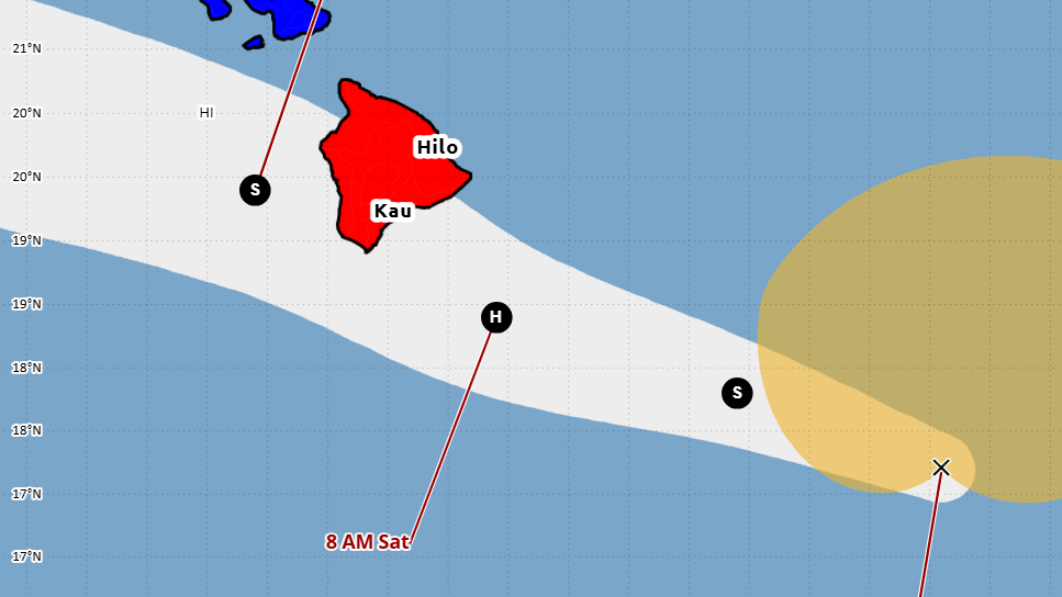

(BIVN) – Tropical Storm Lala continues on its path towards Hawaiʻi island, following a forecasted track that is mostly unchanged from the one issued earlier Friday morning.
Lala is expected to become a category 1 hurricane when it reaches the Big Island on Saturday.
As of 11 a.m. on Friday, Lala was 340 miles east southeast of South Point, moving west northwest at a slightly faster 14 mph. Maximum sustained winds remain near 60 mph (95 km/h) with higher gusts. Steady strengthening is forecast, and Lala is expected to become a hurricane by Saturday.
“When Lala is near the Big Island, short-term deviations in the track are also likely due to local terrain interactions, as depicted in many of the models,” the Central Pacific Hurricane Center stated. “In fact, the model trends and latest guidance now support a landfall on the Big Island on Saturday. After Lala passes the Big Island, a continued west-northwestward track south of the remainder of the islands is expected Saturday night and Sunday.”
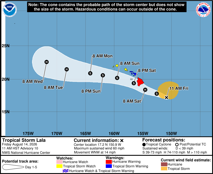
A Hurricane Warning remains in effect for the island of Hawaiʻi. A Flood Watch is also in place, as well as a High Surf Warning for east-facing shores.
Emergency officials say preparations should be rushed to completion today before tropical-storm-force winds begin. Damaging hurricane-force winds are expected on Hawaiʻi island on Saturday, with the strongest wind gusts expected in areas of higher terrain. Lala is also expected to produce rainfall totals of 8 to 12 inches across Maui and Hawaiʻi Island, with maximum totals of 25 inches possible across the Big Island.
A 1 to 3 foot storm surge is possible along the immediate coast.
Commercial ports in Hawaiʻi County are now closed, by order of the U.S. Coast Guard Captain of the Port.
The County of Hawaii will be opening emergency shelters across the island as of 6 p.m. Friday. From a recent Hawaii County Civil Defense message:
- Ikuo Hisaoka Gymnasium, 54-382 Kamehameha Park Road, Kapaʻau.
- Waikoloa Elementary School cafeteria, 68-1730 Hoʻoko St., Waikoloa.
- Kahilu Town Hall, 67-1182 Lindsey Road, Waimea (CORRECTED LOCATION)
- Honokaʻa Gym, 45-541 Lehua St., Honokaʻa.
- Laupāhoehoe Public Charter School Band Room, 35-2605 Mamalahoa Highway, Laupāhoehoe.
- Waiākea High School Gym, 155 W. Kawili St., Hilo
- Keaʻau Armory, 16-512 Volcano Road, Keaʻau.
- Pāhoa Neighborhood Facility, 15-2910 Kauhale St., Pāhoa.
- Robert N. Herkes Gym, 96-1219 Kamani St., Pāhala.
- Nāʻālehu Elementary School gym, 95-5545 Mamalahoa Highway, Nāʻālehu.
- Kealakehe High School Gym, 74-5000 Puohulihuli St., Kailua-Kona.
- Yano Hall, 82-6156 Māmalahoa Highway, Captain Cook.
The Hawaiʻi County Department of Public Works is distributing sandbags, which can be requested by contacting the department at dpwhwy@hawaiicounty.gov or 808-961-8349. For after-hours requests, contact Civil Defense at 808-935-0031.
The County of Hawaiʻi announced on Friday that it is closing all of its parks and solid waste facilities on Saturday. All Hele-On bus routes and Paratransit services will be cancelled on Saturday, Aug. 15 and Sunday, Aug. 16.
The County provided this general safety information on Friday:
- Complete your storm preparations, have a shelter plan, and avoid unnecessary travel by staying off roadways during storm impacts.
- Know the areas that are prone to flooding, especially near your home, and use extra caution around them. Heavy rain uphill from your location can cause flooding, even if it’s not raining where you are.
- Never try to cross moving water, on foot or in a vehicle: “Turn around, don’t drown.”
- Monitor local forecasts from reliable sources for the latest information about the storm and its potential hazards.
- Have a “go bag” ready in case you must evacuate the area, especially if your home is in an area prone to flooding. It should include food, water, necessary medication, important documents, and other necessities for the members of your household (including pets) if you need to leave in a hurry.
- Check the area around your home. Trim tree limbs and secure awnings, umbrellas and other objects that could become airborne and damage your roof or windows. Remove debris that may block drainage and increase the chance of flooding.
- Check in with neighbors, especially those who may have mobility problems, to make sure they have a safe way to evacuate if flooding strikes.
From the Central Pacific Hurricane Center discussion posted at 11 a.m. HST:
Lala is gradually becoming better organized. Satellite images show that the circulation appears less elongated and deep convection has increased some near the center. Despite the improved appearance, the latest satellite intensity estimates suggest that Lala has not strengthened yet. A very recent ASCAT-B pass showed maximum winds around 40 kt north of the center, which is near most of the objective and subjective satellite estimates. The initial intensity is held at a possibly generous 50 kt. Both the NOAA and Air Force Hurricane Hunters will be investigating Lala later today, and the data they collect will be helpful to assess the storm’s structure and intensity.
Lala is moving a little faster to the west-northwest at 12 kt, and this general motion is expected to persist during the next few days as a mid-level high pressure system remains anchored north of the Hawaiian Islands. When Lala is near the Big Island, short-term deviations in the track are also likely due to local terrain interactions, as depicted in many of the models. In fact, the model trends and latest guidance now support a landfall on the Big Island on Saturday. After Lala passes the Big Island, a continued west-northwestward track south of the remainder of the islands is expected Saturday night and Sunday. The NHC track forecast is mostly unchanged from the previous one, and is based on a blend of the latest Google DeepMind, HCCA, and TVCA aids, which have been performing quite well for this storm.
Steady strengthening is expected during the next day or so since the storm appears to be consolidating while environmental conditions remain generally favorable. Lala is expected to become a category 1 hurricane when it reaches the Big Island. Once it interacts with land, Lala is forecast to weaken back to a tropical storm and an increase in shear, associated with an upper-level low, could also contribute to weakening later in the weekend. Re-strengthening is forecast early next week after Lala pulls away from the main Hawaiian Islands. The latest NHC intensity forecast is similar to the previous advisory and remains near the upper end of the guidance envelope.
Key Messages:
1. Damaging hurricane-force winds are expected on the Big Island of Hawaii Saturday, with the strongest wind gusts expected in areas of higher terrain. Preparations should be rushed to completion today before tropical-storm-force winds begin.
2. Heavy rainfall will reach the Big Island later today, and spread westward across the remainder of the island chain this weekend. This rainfall may produce life-threatening flooding and mudslides, especially in areas of steep terrain.
3. Large and dangerous waves, especially on the Big Island, are expected this weekend, with the greatest impacts along exposed windward and southern shores. This heavy surf may cause localized coastal flooding and significant beach erosion.
