
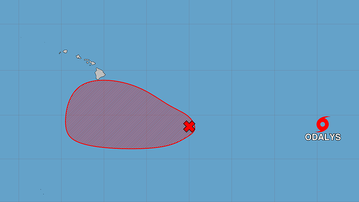

(BIVN) – An area of showers and thunderstorms has increased, several hundred miles to the east-southeast of the Hawaiian Islands.
These remnants of Tropical Depression Fifteen-E could form a tropical depression is likely to form by the middle to latter portion of this week, as the system moves generally westward at 10 to 15 mph.
Forecasters are closely watching this developing area. From the National Weather Service forecast discussion posted at 3 a.m. on Monday morning:
Attention going forward is on the time frame spanning Wednesday into the weekend. Uncertainty is running significantly higher than normal as Former TD-15-E lurks well southeast of the islands and presents as a disorganized area of showers and thunderstorms. General consensus exists that activity will organize during the first half of this week and advance in the general direction of the Big Island thereafter. Initially, uncertainty in system movement likely stems from the current lack of organization and typical uncertainty related to the cyclone`s development sequence. However, by the end of the week, considerable differences arise among the models regarding the evolution of governing mid-latitude troughing as it approaches the state from the north. This will in turn be key to determining placement of the convergent moisture plume wrapping around the NE/E periphery of a potential tropical cyclone.
Broadly speaking, there is consensus that a positively tilted longwave trough will pivot toward the area and spur a closed low NW of Kauai. The remaining portion of the trough then quickly advances SE through the islands and, at some point, forces any tropical system to the south and away from the forecast area. How quickly this unfolds is dependent upon the amplitude and forward motion of the trough. A less phased solution (GFS/UKMET), with a well-defined closed low forming early, shunts the tropical to the south much more quickly and suggests a rather brief/24-hr window for flash flooding potential centered around Thursday. A more phased solution (ECMWF) keeps the longwave trough in tact longer and results in considerable delay forcing the system southward. This makes all the difference as modeled rainfall totals run the gamut from being measured in inches over a day or so to measured in feet over several days. Accordingly, there is concern that the heavy rainfall in the case of a closer brush with this system will occur over the same areas impacted by Hurricane Lala, though this remains far from certain. AI guidance, including the GDM, have been equally unhelpful as they too demonstrate considerable spread given the rather short lead time.
The shift of tails and extreme forecast index derived from the 00z EC ensemble sums up the current modeling situation well. This information hints strongly at high end rain potential over much/all of the Big Island Thursday, Friday, and Saturday with consensus at this time tending to focus on the Hilo Districts and portions of Puna. The official forecast is guided by this information but additional revision to the magnitude and location of the heaviest rainfall is likely during the next couple of days. Maintained isolated thunder in the forecast during this period and introduced mention of heavy rain over the Big Island for the second half of the week.
A Flood Watch the Big Island and possibly Maui will be considered for future forecast packages. Strong trades likely worthy of wind headlines will also develop late this week into the weekend.
Elsewhere in the Pacific, located about 1,415 miles west southwest of Baja California, is Tropical Storm Odalys. This storm is expected to remain over open waters over the next several days, turning towards the northeast by midweek as it strengthens into a hurricane.
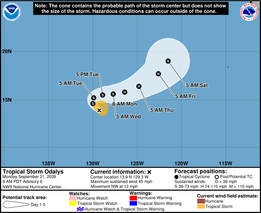
Tropical Storm Odalys does not pose a foreseeable threat to Hawaiʻi.
