
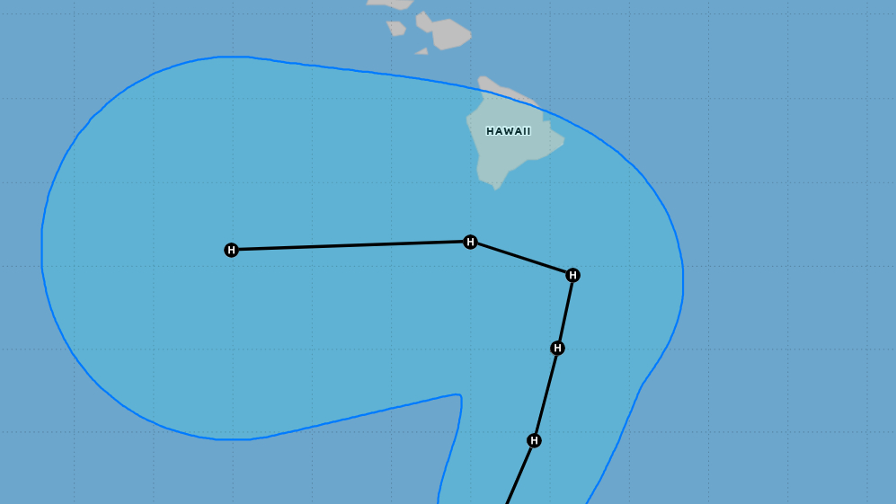

(BIVN) – The remnants of former Tropical Depression Fifteen-E have been reborn, and are expected to strengthen into a hurricane as it approaches Hawaiʻi Island by the end of the week.
The latest iteration of Tropical Depression Fifteen-E was already 405 miles south-southeast of Hilo as of Tuesday night, moving west northwest at 12 mph. When the storm develop into a tropical cyclone, it will be given the name Nolo.
A Flood Watch has already been issued for Hawaiʻi island, but now it looks like a Hurricane or Tropical Storm Watch will be required on Wednesday.
The Central Pacific Hurricane Center reported on Tuesday night that there “is an increasing risk of wind impacts in the Hawaiian Islands regardless of the exact track of this system.”
“Heavy rainfall associated with Tropical Depression Fifteen-E will begin to affect the eastern portions of Hawaiʻi Wednesday,” the Central Pacific Hurricane Center stated. “Periods of heavy rain are likely to continue across the Big Island and Maui through the weekend. Life-threatening, catastrophic flooding and mudslides are possible, especially in areas of steep terrain.”
Swells generated by the storm are expected to reach the east and south-facing shores of the Big Island on Friday.
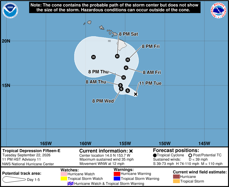
From the Central Pacific Hurricane Center discussion posted at 11 p.m. Tuesday evening:
Recent satellite imagery indicates that the low-level circulation associated with the remnants of former Tropical Depression Fifteen-E has once again become well-defined as the system crossed from the western East Pacific basin into the central Pacific basin. There has been persistent deep convection, mainly in a band to the north and west of the low-level center. Since the remnants have maintained trackable with continuity for over a week since losing its tropical cyclone status, advisories are being re-initiated and the system will retain its original designation as Tropical Depression Fifteen-E. The initial intensity is set at 30 kt and is based on the latest objective intensity estimates from UW-CIMSS. It is worth noting that if the cyclone becomes a tropical storm, it will receive the Central Pacific name Nolo.
The depression is moving west-northwestward at about 10 kt on the southwest side of a low- to mid-level ridge. This ridge is expected to shift eastward and weaken while a mid- to upper-level low dives southwestward near the northwestern Hawaiian Islands. This pattern change should cause the cyclone to slow down and then turn northward or north-northeastward later this week. That motion should take the cyclone near the Big Island of Hawaii late Friday or on Saturday. Around that time, the upper low is expected to weaken and move westward, allowing mid-level ridging to become re-established to the north of the system. In response, the cyclone should turn and then accelerate westward. The NHC track forecast is closest to the best-performing models of the year so far, HCCA and GDMI. Given the complex steering evolution and significant model spread, confidence in the details of the track forecast is low. Interests in the Hawaiian Islands, especially on the Big Island, should closely monitor the system.
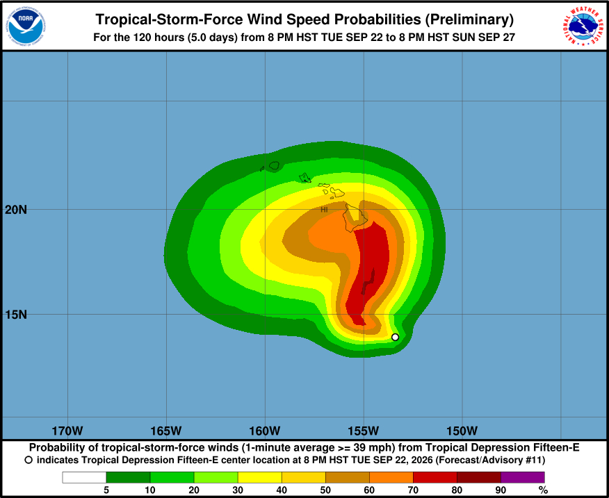
The environmental conditions are favorable for strengthening over the next few days with vertical wind shear expected to be around or less than 10 kt, high mid-level humidities, and SSTs of around 29 C. The only limiting factor is the system’s sprawling low-level structure. Considering these conditions, the NHC intensity forecast calls for slow strengthening to start, followed by more significant intensification when the system moves toward Hawaii. Most of the reliable intensity models are quite aggressive, and the NHC intensity forecast follows a combination of the HAFS guidance and HCCA and GDMI aids. This prediction shows the system becoming a hurricane in a couple of days and nearing major hurricane strength when it approaches the Big Island of Hawaii by the weekend.
Key Messages:
1. Tropical Depression Fifteen-E is expected to strengthen into a tropical storm on Wednesday and a hurricane in a couple of days as it turns northward. Although it is too soon to specify the exact location and magnitude of impacts, interests in Hawaii should closely monitor the latest forecast updates and ensure that they have their preparedness plan in place.
2. Heavy rainfall associated with Tropical Depression Fifteen-E will begin to affect the eastern portions of Hawaii Wednesday. Periods of heavy rain are likely to continue across the Big Island and Maui through Saturday. Life-threatening, catastrophic flooding and mudslides are possible from rainfall totals in excess of a foot, especially in areas of steep terrain. Across the remainder of Hawaii, lesser rainfall totals are expected, with isolated flooding possible.
3. There is an increasing risk of wind and wave impacts in the Hawaiian Islands regardless of the exact track and intensity of the system. Hurricane or Tropical Storm Watches may be required for portions of the Hawaiian Islands on Wednesday.
