
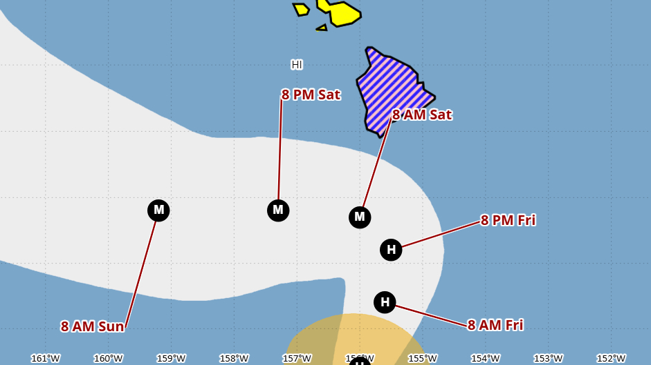

(BIVN) – A Tropical Storm Warning has been issued for Hawaiʻi County, as Tropical Storm Nolo has started to move north at 2 mph.
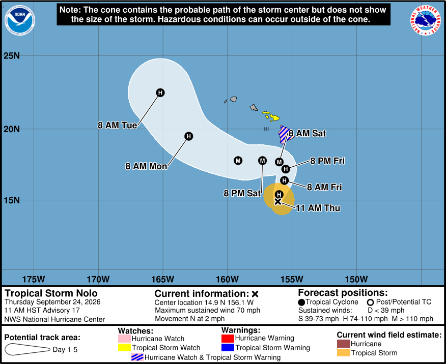
As of 11 a.m. Thursday, Nolo was located 285 miles south of Kaʻū, and was nearing hurricane strength. Nolo is forecast to become a hurricane by tonight and a major hurricane by this weekend.
Nolo spent a portion of Thursday morning stationary, but a faster motion to the north or north-northeast is expected later today through Friday, followed by a sharp westward turn on Saturday in the vicinity of the Big Island, the Central Pacific Hurricane Center says.
On Hawaiʻi island, Tropical storm conditions are expected to begin by late Friday, with hurricane conditions possible by early Saturday. Nolo is expected to produce rainfall totals of 15 to 30 inches with maximum amounts of 35 inches. “This rainfall could produce catastrophic life-threatening flooding and mudslides, especially in areas of steep terrain,” forecasters say.
The new 11 a.m. forecast track has Nolo slightly south at the point on Saturday where it turns hard west, compared to the 5 a.m. forecast.
“The northward trend during the last couple of model cycles has stopped and is actually trending southward, led by the ECMWF model,” the Central Pacific Hurricane Center wrote. “The new forecast is a touch south of the last one, but really all these track changes are quite small. This remains an uncertain forecast with some model ensemble tracks still over the Big Island, though most are south. This forecast necessitates a Tropical Storm Warning for the Big Island, and a closer track could substantially increase the threat of damaging winds, particularly over higher terrain, along exposed ridges, and in areas downwind of the ridges.”
The Hawaiʻi County Civil Defense says all pre-landfall preparations should be completed before onset of high surf, wind, and rain.
- Boat owners and those with shoreline property should complete securement.
- Prepare your property for heavy rains and flooding
- Take this time to secure loose outdoor items prior to the onset of winds
Hawaiian Electric says it is proactively preparing to respond to the latest storm threat.
“With Tropical Storm Nolo’s potential to impact our service territories, we’re taking every action possible to ensure we are ready to respond and can do so quickly to safely restore power to customers who may be affected,” said Jim Alberts, Hawaiian Electric’s senior vice president and chief operations officer.
“Downed trees and branches are some of the biggest causes of damaged power poles, lines and equipment in a storm,” said Alberts. “During Hurricane Lala, vegetation and flooding caused roughly 90% of the power outages on Hawaiʻi Island. On Oʻahu and Maui County, it was about 50%.”
From the Central Pacific Hurricane Center discussion posted at 11 a.m. HST:
Nolo continues to become better organized, with a ragged eye on satellite imagery and a primitive eyewall noted on the latest microwave pass. The initial intensity is set to 60 kt, at the high end of the various estimates due to the improved organization on conventional satellite and microwave imagery. An Air Force Reserve Hurricane Hunter aircraft is scheduled to be in the storm this afternoon for a more precise estimate.
The storm has been moving erratically during the day, but appears to finally be moving slowly northward. There is no change the synoptic reasoning with a mid-latitude trough near the northwestern Hawaiian Islands causing Nolo to accelerate north-northeastward during the next day or so. The trough should move away by the weekend and be replaced by a ridge, forcing a sharp westward turn on Saturday. The northward trend during the last couple of model cycles has stopped and is actually trending southward, led by the ECMWF model. The new forecast is a touch south of the last one, but really all these track changes are quite small. This remains an uncertain forecast with some model ensemble tracks still over the Big Island, though most are south. This forecast necessitates a Tropical Storm Warning for the Big Island, and a closer track could substantially increase the threat of damaging winds, particularly over higher terrain, along exposed ridges, and in areas downwind of the ridges.
Rapid intensification is expected during the next day or so now that an inner core has formed, combined with warm warm SSTs, low shear and high mid-level moisture. Nolo is likely to become a hurricane by tonight and reach major hurricane strength as it nears the Big Island on Saturday. The new forecast is similar to the previous one for the first few days, close to the HCCA aid. At long range, vertical wind shear is forecast to cause Nolo to weaken, and the NHC intensity prediction is lowered at that time.
Key Messages:
1. Nolo is expected to pass near or just south of the Big Island of Hawaii on Saturday as a major hurricane. Tropical storm conditions are expected to begin on the Big Island Friday night with hurricane conditions possible on Saturday, particularly in areas of steep terrain. Residents should follow advice given by local officials, including evacuating if told to do so.
2. The time to finish preparations for significant heavy rain and flooding impacts on the Big Island is now as heavy rain increases in both coverage and intensity today and Friday. Periods of heavy rain are expected to continue across the Big Island and Maui through the weekend. Life-threatening, catastrophic flooding and mudslides are possible, especially in areas of steep terrain across the Big Island and Maui. Across the remainder of Hawaii, lesser rainfall totals are expected, with isolated flooding possible.
3. Large and damaging waves are likely along portions of the Big Island’s coastline into the weekend.
4. A Tropical Storm Watch is in effect for Maui County where tropical storm conditions are possible beginning on Saturday. Interests elsewhere in Hawaii should closely monitor the latest forecast updates and ensure that they have their preparedness plans in place.
