


(BIVN) – Nolo has officially become a hurricane.
As of 5 p.m. Thursday evening, Nolo was located 270 miles south of Kaʻū on Hawaiʻi island, moving north-northeast at 5 mph.
“The Air Force Reserve Hurricane Hunters have been flying through Nolo this afternoon, and found a peak flight-level wind of 71 kt and a minimum central pressure down to 984 mb in their most recent fix,” the Central Pacific Hurricane Center stated, which is enough to upgrade Nolo to a hurricane.
Nolo is expected to rapidly intensify as it nears the Big Island late Friday, before it eventually turns toward the west Saturday.
A Tropical Storm Warning and Hurricane Watch remain in place for Hawaiʻi County. Tropical storm conditions are expected to begin by late Friday in the warning area, with hurricane conditions possible by early Saturday.
Heavy rainfall, with totals of 15 to 30 inches with maximum amounts of 35 inches, could produce catastrophic, life-threatening flooding and mudslides, especially in areas of steep terrain.
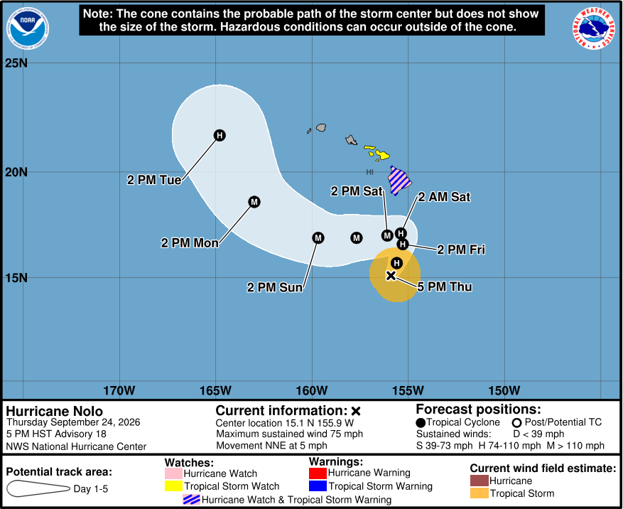
In a welcome trend, the forecast shows Hurricane Nolo’s eventual westward turn taking it farther to the south of Hawaiʻi island.
“The track guidance has made a rather substantial southward shift compared to the previous cycle, and the NHC track forecast has been shifted southward, though it remains on the northern side of the guidance envelope,” the Central Pacific Hurricane Center commented. “This track forecast lies closest to the Google DeepMind ensemble mean (GDMI) which is actually a northern outlier this cycle, so it’s possible future southward adjustments may be necessary.”
Hawaiʻi County announced it will be opening additional shelters Friday morning.
“Tropical Storm Nolo continues to strengthen and threaten Hawai‘i Island,” said Mayor Kimo Alameda in a news release. “We are looking at both the possibility of life-threatening flash flooding and strong, damaging winds, and we encourage everyone to complete their preparations, stay connected to official alerts and weather updates, and secure safe shelter before flooding strikes.”
Shelters Currently Open
- Yano Hall, 82-6156 Māmalahoa Highway, Captain Cook
- Nāʻālehu Elementary School gym, 95-5545 Mamalahoa Highway, Nāʻālehu
- Robert N. Herkes Gym, 96-1219 Kamani St., Pāhala
- Keaʻau Armory, 16-512 Volcano Road, Keaʻau
Shelters Opening Friday, Sept. 25 at 6 a.m.
- Honoka‘a Gym, 45-541 Lehua St., Honoka‘a
- Pāpa‘aloa Park Annex, 35-1994 Government Main Road, Pāpa‘aloa
- Pu‘u‘eo Community Center, 145 Wainaku St., Hilo
- Kahilu Town Hall, 67-1182 Lindsey Road, Waimea
- Ocean View Community Center, 92-8924 Leilani Circle, Ocean View
Hawaiʻi County added this information on operations:
County Closures
Non-emergency County services and operations are suspended today and Friday. The closure includes County offices, all park facilities, and regular Hele-On services (fixed routes and paratransit). Solid waste facilities that are scheduled to be open today are open; all solid waste facilities will be closed on Friday and Saturday.
Shuttle Service
The Mass Transit Agency’s shuttle service is Thursday, Sept. 24 from 2 p.m.-6 p.m. from Nāʻālehu Elementary School to the shelter at Robert N. Herkes Gym in Pāhala.
Sandpiles
For residents in need of sandbags, sandpile locations are available at the following locations. Bring your own sandbag.

In a Thursday afternoon news release, Hawaiian Electric urged customers to prepare for the possibility of extended power outages.
“In the past 24 hours, we’ve increased our staffing and have teams standing by to restore power as quickly as possible,” said Jim Alberts, Hawaiian Electric’s senior vice president and chief operations officer. “As long as it’s safe, we’ll work continuously after the storm clears until all customers have power again.”
From the Central Pacific Hurricane Center discussion posted at 5 p.m. HST:
Nolo’s structure on satellite imagery continues to gradually improve with a banding-type eye trying to develop on visible satellite imagery. The Air Force Reserve Hurricane Hunters have been flying through Nolo this afternoon, and found a peak flight-level wind of 71 kt and a minimum central pressure down to 984 mb in their most recent fix. These values are enough to upgrade Nolo to a hurricane this advisory, with an initial intensity of 65 kt.
The storm is finally moving more consistently to the north-northeast with an estimated motion at 020 degrees at 4 kt. There is little change to the track reasoning this cycle, with a deep-layer trough located to the northwest of Nolo helping to steer it slowly to the north-northeast over the next 24-36 h. Thereafter, this trough cuts off to the west of the Hawaiian islands and moves westward out of the way, allowing mid-level ridging to build back in north of Nolo. The net result of this synoptic change is that Nolo is expected to make a sharp turn to the west, or even west-southwest in the 48-72 h time frame. However, the aforementioned cutoff low still limits how far west this mid-level ridging is able to extend, and Nolo will likely begin to gain latitude in the day 4-5 day time frame. The track guidance has made a rather substantial southward shift compared to the previous cycle, and the NHC track forecast has been shifted southward, though it remains on the northern side of the guidance envelope. This track forecast lies closest to the Google DeepMind ensemble mean (GDMI) which is actually a northern outlier this cycle, so it’s possible future southward adjustments may be necessary.
Even though Nolo is now a hurricane, the Air Force Reconnaissance aircraft has yet to report a closed eyewall in either of its fixes through the hurricane, and the wind field is a little bit on the broader side. However, environmental conditions appear quite favorable with low shear, sufficently warm sea-surface temperatures and enough deep-layer moisture to support robust intensification. The NHC intensity forecast continues to forecast significant intensification, and now shows a peak intensity of 115 kt as Nolo turns westward in the 48-72 h time frame. This intensity forecast is a blend of the latest HFIP Corrected Consensus Approach (HCCA) and HAFS-A/B runs, even though the HCCA remains the highest outlier in the intensity guidance this cycle. At long range, vertical wind shear is expected to increase, and the NHC intensity shows weakening beginning by day 5.
Key Messages:
1. Nolo is expected to pass near or just south of the Big Island of Hawaii on Saturday as a major hurricane. Tropical storm conditions are expected to begin on the Big Island Friday night with hurricane conditions possible on Saturday, particularly in areas of steep terrain. Residents should follow advice given by local officials, including evacuating if told to do so.
2. The time to finish preparations for significant heavy rain and flooding impacts on the Big Island is now as heavy rain increases in both coverage and intensity today and Friday. Periods of heavy rain are expected to continue across the Big Island and Maui through the weekend. Life-threatening, catastrophic flooding and mudslides are possible, especially in areas of steep terrain across the eastern and southern portions of the Big Island and Maui. Across the remainder of Hawaii, lesser rainfall totals are expected, with isolated flooding possible.
3. Large and damaging waves are likely along portions of the Big Island’s coastline into the weekend.
4. A Tropical Storm Watch is in effect for Maui County where tropical storm conditions are possible beginning on Saturday. Interests elsewhere in Hawaii should closely monitor the latest forecast updates and ensure that they have their preparedness plans in place.
