
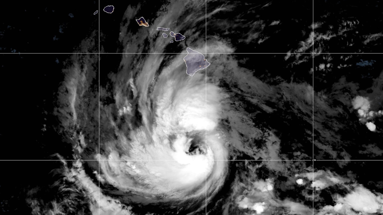

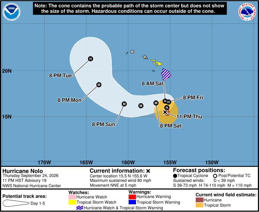
(BIVN) – As of 11 p.m. Thursday evening, Hurricane Nolo was located 240 miles south of Kaʻū on Hawaiʻi island. Nolo is strengthening as it moves north-northeast at 5 mph.
A Tropical Storm Warning and Hurricane Watch remain in place for Hawaiʻi County. Tropical storm conditions are expected to begin by late Friday in the warning area, with hurricane conditions possible by early Saturday.
The official forecast track for Nolo has again pushed south, and shows a slightly earlier turn to the west, putting the storm a little farther from Hawaiʻi island.
As of 11 p.m., data from an Air Force Reserve reconnaissance aircraft indicate that maximum sustained winds have increased to near 80 mph with higher gusts. Nolo is expected to rapidly intensify into a major hurricane on Saturday, before it eventually turns toward the west.
As of Thursday night, Nolo’s hurricane-force winds were extending outward up to 40 miles from its center, and tropical-storm-force winds were extending outward up to 105 miles.
Nolo will produce rainfall totals of 15 to 30 inches with maximum amounts of 35 inches for eastern and southern portions of the Big Island, forecasters say, which could produce “catastrophic life-threatening flooding and mudslides, especially in areas of steep terrain.”
Western portions of the Big Island could see rainfall totals of 5 to 8 inches, with maximum amounts of 10 inches, officials say.
From the Central Pacific Hurricane Center at 11 p.m. HST:
An Air Force Reserve reconnaissance mission has provided some conflicting data regarding Nolo’s current intensity. On one hand, the plane measured a peak flight-level wind of 81 kt in the southeastern eyewall, which reduces to an intensity of 70-75 kt. On the other hand, the central pressure has not fallen since the previous mission, with the latest dropsonde data suggesting around 985 mb, and the 700-mb height has risen a bit. For now, the initial intensity is raised conservatively to 70 kt. Deep convection is becoming more symmetric around the eye, which is a bit ragged and elliptical.
The initial motion remains north-northeastward, or 030/4 kt, with Nolo being steered by a deep-layer trough located west of the Hawaiian Islands. This trough is expected to weaken and drift westward during the next 24-36 hours, with strong mid-level ridging taking its place over and north of Hawaii. As a result, Nolo is expected to come to a crawl by Friday night and early Saturday and then begin to move south of due west through Sunday. The track guidance has again shifted southward, responding to the strengthening ridge, and the NHC forecast lies near the northern edge of the envelope, closest to the Google DeepMind ensemble mean (GDMI). With nearly every other major model lying south of the official forecast, additional southward shifts in future advisories are possible, but not yet a guarantee. The previously mentioned deep-layer trough is expected to re-amplify later in the forecast period, which is expected to cause Nolo to turn northwestward and then north-northwestward by Monday and Tuesday.
Various shear analyses suggest that Nolo is experiencing moderate deep-layer shear out of the south-southeast, which may be contributing to the broken eyewall on the east side. However, the shear is expected to abate during the next 24-36 hours, and along with warm sea surface temperatures, should support continued strengthening. There is a bit of model disagreement on exactly how much strengthening will occur, but it is noteworthy that the typically skillful HCCA model, as well as HAFS-A, shows Nolo reaching high-end category 4 strength in 3-4 days. As a result, the NHC intensity forecast has been increased slightly at that forecast time. Weakening is anticipated by days 4 and 5 due to a marked increase in southwesterly shear east of the trough.
Key Messages:
1. Nolo is expected remain south of the Big Island of Hawaii through Saturday before turning westward and moving away from the island. Tropical storm conditions are expected to begin on the Big Island Friday night with hurricane conditions possible on Saturday, particularly in areas of steep terrain. Residents should follow advice given by local officials, including evacuating if told to do so.
2. The time to finish preparations for significant heavy rain and flooding impacts on the Big Island is now as heavy rain increases in both coverage and intensity on Friday. Periods of heavy rain are expected to continue across the Big Island and Maui through the weekend. Life-threatening, catastrophic flooding and mudslides are possible, especially in areas of steep terrain across the eastern and southern portions of the Big Island and Maui. Across the remainder of Hawaii, lesser rainfall totals are expected, with isolated flooding possible.
3. Large and damaging waves are likely along portions of the Big Island’s coastline into the weekend.
4. A Tropical Storm Watch is in effect for Maui County where tropical storm conditions are possible beginning on Saturday. Interests elsewhere in Hawaii should closely monitor the latest forecast updates and ensure that they have their preparedness plans in place.
