
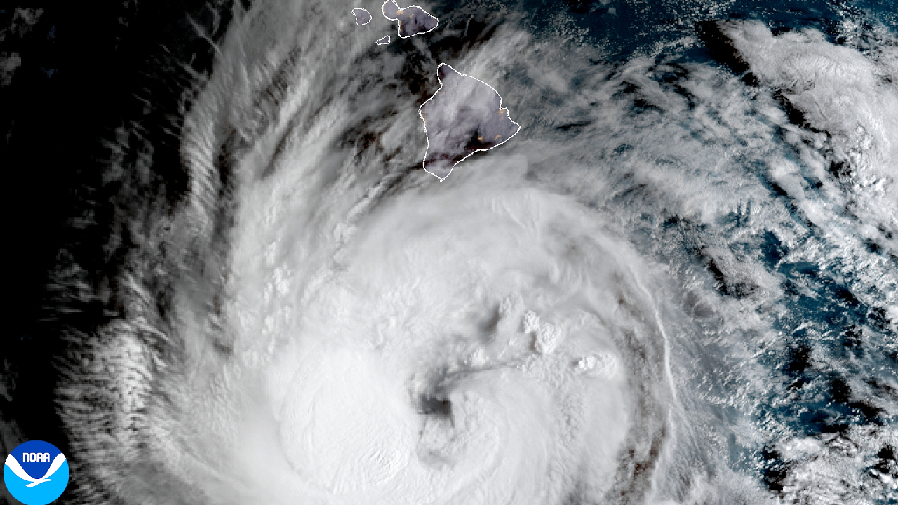

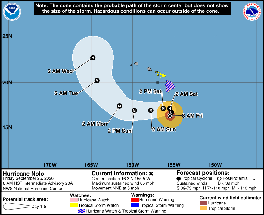
(BIVN) – Hurricane Nolo was located 185 miles south of Kaʻū as of 8 a.m. Friday morning, moving north-northeast at 5 mph.
A Tropical Storm Warning and Hurricane Watch remain in place for Hawaiʻi County. Tropical storm conditions are expected to begin by late Friday in the warning area, with hurricane conditions possible by early Saturday. Nolo is expected to make a westward turn on Saturday, well before it reaches Hawaiʻi island.
“Model guidance has, unfortunately, not been very consistent on exactly when this westward turn occurs, as there has been a shift to the north on this cycle,” the Central Pacific Hurricane Center says. “This new forecast is moved in that direction through the weekend, though still a fair distance south of Hawaiʻi.”
The maximum amount of rainfall to be expected from Nolo has also trended down, 25 inches on the high end rather than 35 inches. Still, Nolo could cause “catastrophic and life-threatening flash flooding on the Big Island” this weekend.
As of Friday morning, Nolo’s hurricane-force winds were extending outward up to 45 miles from its center, and tropical-storm-force winds were extending outward up to 115 miles.
The Hawaiʻi County Civil Defense says all pre-landfall preparations should be completed before onset of high surf, wind, and rain which is forecast to begin late this afternoon.
- Boat owners and those with shoreline property should complete securement.
- Prepare your property for heavy rains and flooding
- Take this time to secure loose outdoor items prior to the onset of winds
- Eight shelters are open for your use: Naʻalehu Gym, Herkes Gym, Keaau Armory, Yano Hall, Kahilu Town Hall, Honokaʻa Gym, Papaʻaloa Gym, and the Ocean View Community Center.
From the Central Pacific Hurricane Center’s most recent discussion posted at 5 a.m. HST:
Nolo continues on a gradual strengthening trend this morning. On the last pass through the hurricane, Air Force Hurricane Hunters reported that the pressure had dropped to about 980 mb, and satellite imagery shows deepening convection in the ragged eyewall. On this basis, the initial intensity is set to 75 kt, which is also at the top end of the various satellite estimates.
The hurricane is moving north-northeastward at 4 kt, as it is being steered by a deep-layer trough located west of the Hawaiian Islands. This trough should begin to move away from Nolo on Saturday, causing the hurricane to drift westward while it is located south of Hawaii. A westward motion with increasing forward speed is then expected by early Sunday due to a ridge re-building. Model guidance has, unfortunately, not been very consistent on exactly when this westward turn occurs, as there has been a shift to the north on this cycle. This new forecast is moved in that direction through the weekend, though still a fair distance south of Hawaii. At long range, Nolo should again encounter the aforementioned upper-level trough, now re-invigorated, which should cause a north-northwestward turn early next week. No significant changes were made to the long-range NHC forecast.
Nolo should further intensify today, though rapid intensification is not expected due to its large radius-of-maximum wind, moderate shear and some dry mid-level air in the northern semicircle. The shear is forecast to weaken in about 36 hours, which should allow the hurricane to significantly intensify. Additionally, Nolo could be moving over a patch of high ocean heat content, and model guidance is in better agreement on this system becoming rather strong by early next week. The new forecast is similar to the previous one but raised just a bit through day 3 to come into better agreement with the typically skillful HCCA model. Weakening is expected by days 4 and 5 due to forecast strong southwesterly shear east of the trough.
Key Messages:
1. Nolo is expected to remain south of the Big Island of Hawaii through Saturday before turning westward and moving away from the island. Tropical storm conditions are expected to begin on the Big Island tonight with hurricane conditions possible on Saturday, particularly in areas of steep terrain. Residents should follow advice given by local officials, including evacuating if told to do so.
2. The time to finish preparations for significant heavy rain and flooding impacts on the Big Island is now as heavy rain increases in both coverage and intensity today. Periods of heavy rain are expected to continue across the Big Island and Maui through the weekend. Life-threatening, catastrophic flooding and mudslides are possible, especially in areas of steep terrain across the eastern and southern portions of the Big Island and Maui. Across the remainder of Hawaii, lesser rainfall totals are expected, with isolated flooding possible.
3. Large and damaging waves are likely along portions of the Big Island’s coastline into the weekend.
4. A Tropical Storm Watch is in effect for Maui County where tropical storm conditions are possible beginning on Saturday. Interests elsewhere in Hawaii should closely monitor the latest forecast updates and ensure that they have their preparedness plans in place.
