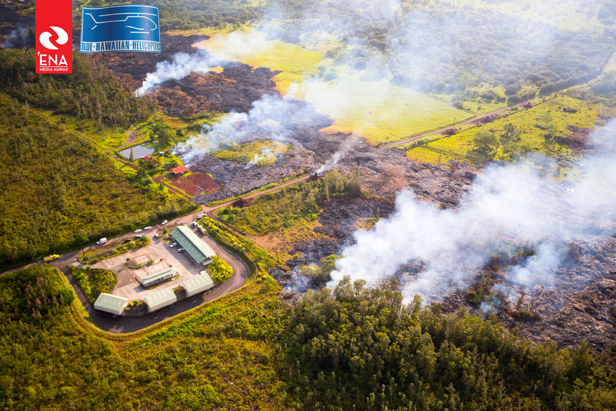
(ABOVE PHOTO) Aerial photo taken Monday morning – before the burning of the home off Cemetery Road – shows the numerous active lava lobes in the area of Apa’a Street and the transfer station. Image courtesy Ena Media Hawaii / Blue Hawaiian Helicopters
NEWS BRIEFS
- The flow front remains stalled 480 feet from the Pahoa Village Road and has not advanced.
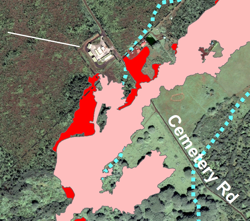
- Three active breakouts – in the area of the cemetery below Apa’a Street, above Apa’a Street in the area west or upslope of the transfer station, and .4 miles upslope of Apa’a Street – continue to advance and be monitored.
PRIMARY SOURCES

This morning’s assessment shows that the flow front remains stalled with very little activity and has not advanced. The front remains approximately 480 feet from the Pahoa Village Road.
Three active breakouts continue to advance and be monitored. These breakouts are located in the area of the cemetery below Apa’a Street, above Apa’a Street in the area west or upslope of the transfer station, and .4 miles upslope of Apa’a Street. These breakouts currently do not pose an immediate threat to area residents and will be monitored closely.
Smoke conditions are currently moderate to heavy with light trade winds blowing the smoke in a south southwest direction towards the Leilani and lower Puna areas. Smoke conditions may increase in some areas and residents down wind that may be sensitive or have respiratory problems are advised to take necessary precautions and to remain indoors.
The evacuation advisory for those residents down slope of the flow will continue and residents will be kept informed of the flow status and advancement.
The Pahoa Village Road between Apa’a Street and the Post Office Road will remain closed and limited to area residents only. In addition, Civil Defense and public safety personnel will be operating in the area round the clock to maintain close observations of flow activity. Additional updates will be broadcasted as conditions change.Hawaii County Civil Defense on Nov. 11 at 8 a.m. HST

Kīlauea volcano continues to erupt at its summit and within its East Rift Zone. The leading edge of the June 27th lava flow has not advanced beyond where it stalled on October 30. HVO scientists conducted a helicopter overflight on Monday morning and observed localized breakouts of lava in scattered locations upslope of the stalled leading flow edge. Breakouts near Apaʻa Street moved to within 20 m (22 yards) of the transfer station fence, and ignited an unoccupied home at 1155h on Monday. Other breakouts were active further upslope, the most vigorous of which was located on the north side of the main flow and whose leading edge extended to about 750 m (820 yards) above Apaʻa Street. Inflationary tilt began at Kīlauea’s summit on Monday afternoon, and the surface of the summit lava lake at Halemaʻumaʻu Crater rose from the previous day.
June 27th Lava Flow Observations: HVO scientists conducted a helicopter overflight on Monday morning to assess the progress of the lava flow. The leading edge of the flow had not advanced beyond where it stalled on October 30, in a residential area approximately 155 meters (170 yards) above Pāhoa Village Road, but breakout activity continued in areas upslope of the leading edge. The closest active lava to Pāhoa Village Road was located about 450 meters (500 yards) upslope of the road, below the Pāhoa cemetery. Near Apaʻa Street, lava moved to within about 20 meters (22 yards) of the transfer station fence and expanded on private property on the northeast side of the street. At 1155h on Monday an unoccupied home on that lot was ignited by the advancing lava. Other breakouts extended from roughly 450 m (490 yards) to 2.7 km (1.7 miles) upslope of Apaʻa Street. The most vigorous activity of the June 27th flow was ~1 km (0.6 miles) above Apaʻa Street on the north side of the flow; this lobe was active on all fronts and extended downslope to a point about 750 m (820 yards) from Apaʻa Street.
Puʻu ʻŌʻō Observations: No significant changes were noted near Puʻu ʻŌʻō. Seismic tremor continued with relatively steady amplitude, no earthquakes were located in the vicinity of the cone, and webcams revealed no strong variations in the pattern of glow from degassing vents nor the configuration of the crater floor. During their Monday overflight, HVO scientists observed small incandescent openings in the north, northeast, south, and southeast pits in Puʻu ʻŌʻō’s crater. The tiltmeter at Puʻu ʻŌʻō showed little change, although following its recent repair the data from this instrument cannot yet be considered completely reliable. The GPS-measured length across the cone has not changed significantly since July. Several earthquakes were located beneath Kīlauea’s East Rift Zone and south flank. The most recent measurement of sulfur dioxide emissions from the East Rift Zone was 320 tonnes per day on October 31, 2014.
Summit Observations: Inflationary summit tilt began on Monday afternoon and has continued at a decreasing rate. The surface height of the lava lake in the Overlook vent was measured at 52 m (57 yards) below the vent rim on Monday at 0955h, and thermal camera images show that the surface has risen since that time in association with the ongoing inflationary summit tilt. Several small earthquakes were located beneath the summit, and volcanic tremor persisted with a fluctuating amplitude. Small amounts of particulate material were carried aloft by the plume. Summit emissions of sulfur dioxide ranged from 3,400 to 6,400 tonnes/day (see caveat below) through the week-long period ending November 4, 2014. USGS Hawaiian Volcano Observatory on Nov. 11 at 8:29 a.m. HST