(ABOVE) Civil Defense Lava Flow Map updated Monday, Feb. 2 at 7:00 a.m. HST
NEWS BRIEFS
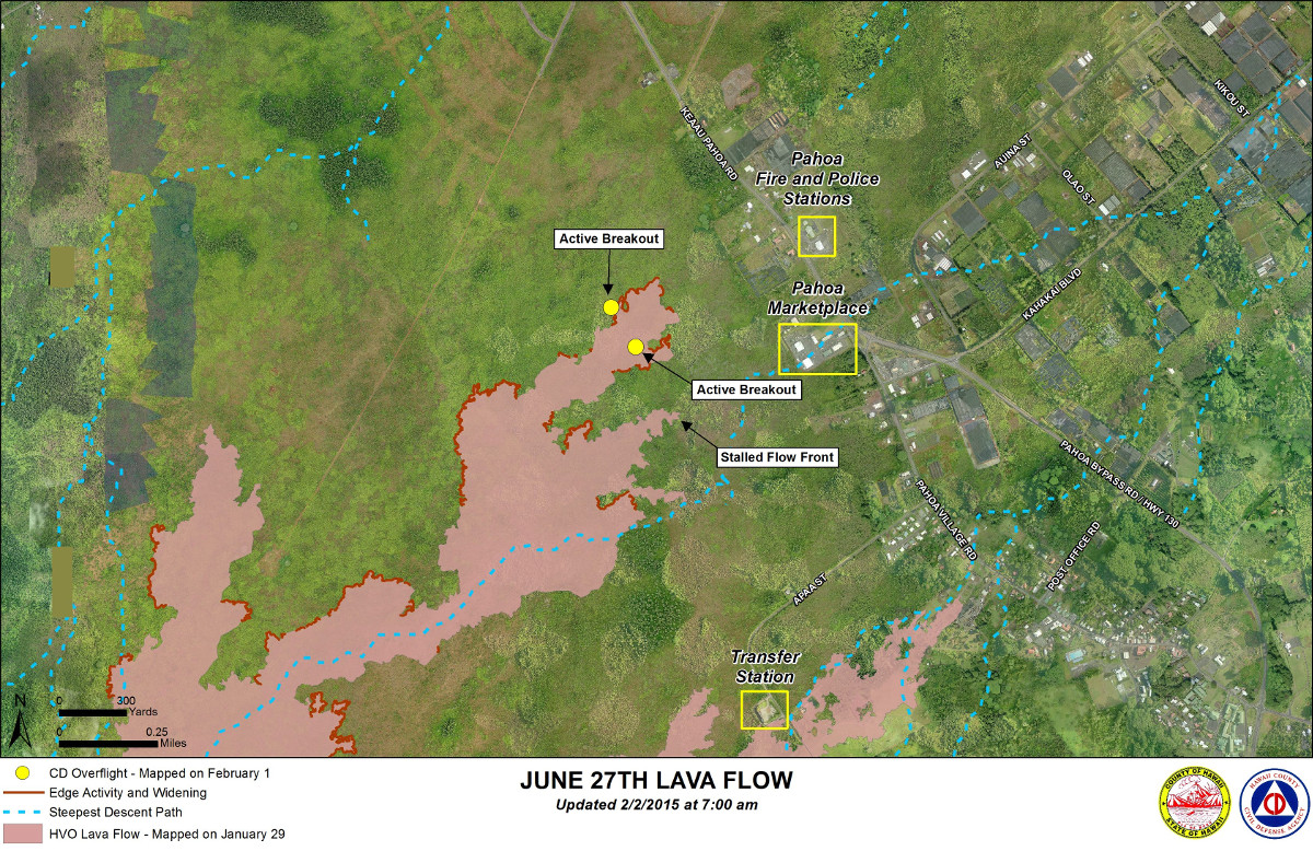
- There has been no advancement of any of the down slope lava flow areas. Hawaii County Civil Defense says all visible activity was limited to breakouts within or on the surface of the lava pad and breakouts along both margins further upslope.
- On Friday, Mayor Billy Kenoi has signed his Third Emergency Supplementary Proclamation due to the imminent threat of the lava disaster, extending the previous emergency proclamations for another 60 days.
- Smoke and vog conditions were moderate to heavy with a light south wind blowing the smoke in a northeast direction.
- The Public Lava Viewing area was closed for good on Sunday in order to begin work on restoring the Pahoa Transfer Station to normal operations by March 1st.
PRIMARY SOURCES

This morning’s assessment continues to show no advancement of any of the down slope flow areas and all visible activity was limited to breakouts within or on the surface of the lava pad and breakouts along both margins further upslope. The leading edge or front of the furthest down slope flow area remains approximately 0.36 miles from the area of Highway 130 to the west or mauka of the Pahoa Police and Fire Stations and again, showing no signs of advancement. The Hawaii County Civil Defense Agency and Hawaiian Volcano Observatory are maintaining close observations of the flow. Residents and businesses down slope will be informed of any changes in flow activity and advancement.
Smoke and vog conditions were moderate to heavy with a light south wind blowing the smoke in a northeast direction. Smoke conditions may increase in some areas and individuals who may be sensitive or have respiratory problems are advised to take necessary precautions and to remain indoors. No brush fire activity was noted this morning and fire conditions will be monitored closely.
The community is reminded that the Public Lava Viewing area at the Pahoa Transfer Station has been closed effective yesterday Sunday February 1st. This is to allow for the restoration of the transfer station and to restore normal operations by March 1st. We apologize for any inconvenience this may cause and thank everyone for your patience and understanding.
On behalf of the Hawaii County Civil Defense Agency and our partners we would like to thank everyone for your assistance and cooperation. Hawaii County Civil Defense on Feb. 2 at 7:30 a.m. HST

Kīlauea Volcano continues to erupt at its summit and from its East Rift Zone. The leading tip of the June 27th lava flow remains roughly 500 m (~550 yd) from Highway 130 in the area west of the Pāhoa Fire and Police Stations. The flow has not advanced in the past week, although breakouts are active upslope. Monitoring instruments at the summit and around Puʻu ʻŌʻō show no significant changes over the past 24 hours.
June 27th Lava Flow Observations: The Civil Defense overflight on Monday morning observed that none of the flow lobes that are near Highway 130 have advanced in the past 24 hours, and that breakouts were confined to the flow interior and margins. Overnight webcam views indicate a few scattered breakouts across the lower portion of the flow field.
Puʻu ʻŌʻō Observations: A small amount of inflation was recorded by the tiltmeter on the north flank of Puʻu ʻŌʻō, but otherwise eruptive activity has been steady. Webcams show a few spots of fluctuating glow emanating from small pits within the crater, and seismic tremor has remained low. The rate of sulfur dioxide emission from all East Rift Zone vents was about 200 tonnes per day, measured on January 7.
Summit Observations: There was no net tilt at the summit over the past 24 hours. The lava level, measured on Sunday evening, was about 42 meters (140 feet) below the vent rim. Typical minor fluctuations in level occurred over the past day due to changes in spattering. Another collapse of the fresh lava veneer on the vent wall just above the lake surface occurred at about 3:39 AM HST on Monday. Emission rates of sulfur dioxide ranged from around 4,400 to 5,100 tonnes/day during the week ending on January 27.USGS Hawaiian Volcano Observatory on Feb. 2 at 7:56 a.m. HST